By Whereig Editors, Reviewed by Mukesh Kumar| Updated On: May 02, 2026 | 20:16 ET
Map of Crawford County - Crawford County is a county located in the U.S. state of Indiana. Crawford County Map showing cities, highways, important places and water bodies. Get Where is Crawford County located in the map, major cities in Crawford county, population, areas, and places of interest.
Map of Crawford County, Indiana
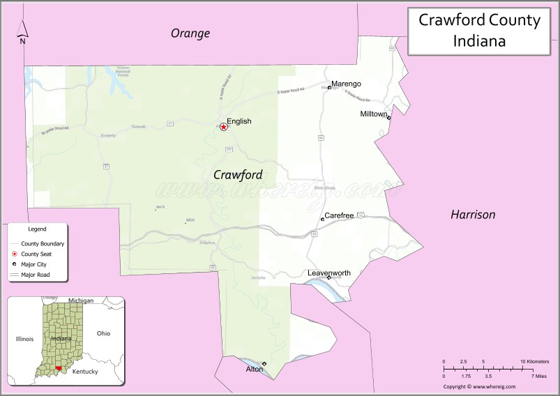
About Crawford County Map, Alabama: The map showing the county boundary, county seat, major cities, highways, water bodies and neighbouring counties.
Related Indiana Maps
About Crawford County, Indiana
Elkhart County is a county located in the U.S. state of Indiana. It`s county seat is Goshen. As per 2020 census, the population of Elkhart County was 206921 and population density of Elkhart was square miles. According to the United States Census Bureau, the county has a total area of 463 sq mi (1,199 km2). Elkhart County was established on -25537.
Crawford County Facts
| Continent | North America |
| Country | United States |
| State | Indiana |
| County Seat | English |
| Largest City/Town | English |
| Established | 1818 |
| Total Area | 306 sq mi |
| Land Area | 306 sq mi |
| Water Area | 0.3 sq mi |
| Population | 10,526 (Census 2020) |
| Population Density | 34 people per sq mi |
| Time Zone | Eastern Time Zone (ET) |
| Major Highways | IN-37, IN-62, IN-66 |
| Neighboring Counties | Orange County (north), Washington County (east), Harrison County (south), Perry County (west), Dubois County (northwest) |
| Famous For | Hoosier National Forest, caves, outdoor recreation |
| Top Attractions | Wyandotte Caves, Marengo Cave, Patoka Lake (nearby) |
| Official Website | https://crawfordcounty.in.gov/ |
Cities and Towns in Crawford County, Indiana
- English (county seat) – 608 (Census 2020)
- Marengo – 828 (Census 2020)
- Alton – 50 (Census 2020)
Roads and Highways in Crawford County, Indiana
Crawford County is served by scenic state highways that pass through forests, hills, and small communities in southern Indiana.
- Indiana State Road 37 – north-south route connecting the county to Bloomington and Tell City
- Indiana State Road 62 – runs east-west linking Corydon to Leavenworth and beyond
- Indiana State Road 66 – scenic highway along the Ohio River connecting southern Indiana towns
Neighboring Counties of Crawford County
- Orange County (north)
- Washington County (east)
- Harrison County (south)
- Perry County (west)
- Dubois County (northwest)
Top Attractions in Crawford County, Indiana
Crawford County is known for its natural beauty, caves, and outdoor recreation areas.
- Wyandotte Caves – one of the largest cave systems in Indiana
- Marengo Cave – popular cave with guided tours and underground formations
- Hoosier National Forest – large forest area for hiking, camping, and wildlife viewing
- Patoka Lake (nearby) – boating, fishing, and camping destination
- Blue River – scenic river for kayaking and canoeing
- Crawford County Community Park – local park with outdoor facilities
Distance from Crawford County to Nearby Cities
- Crawford County to Louisville – 45 mi (72 km)
- Crawford County to Indianapolis – 120 mi (193 km)
- Crawford County to Evansville – 80 mi (129 km)
- Crawford County to Bloomington – 70 mi (113 km)
- Crawford County to Cincinnati – 130 mi (209 km)
FAQs about Crawford County
Crawford County is located in southern Indiana.
The county seat is English, which is also the largest town in the county.
It is known for caves, forests, and outdoor recreation areas.
Yes, it is largely rural with forests, hills, and small communities.
The main highways include Indiana State Roads 37, 62, and 66.
- Adams County Map, IN
- Allen County Map, IN
- Bartholomew County Map, IN
- Benton County Map, IN
- Blackford County Map, IN
- Boone County Map, IN
- Brown County Map, IN
- Carroll County Map, IN
- Cass County Map, IN
- Clark County Map, IN
- Clay County Map, IN
- Clinton County Map, IN
- Crawford County Map, IN
- Daviess County Map, IN
- Dearborn County Map, IN
- Decatur County Map, IN
- DeKalb County Map, IN
- Delaware County Map, IN
- Dubois County Map, IN
- Elkhart County Map, IN
- Fayette County Map, IN
- Floyd County Map, IN
- Fountain County Map, IN
- Franklin County Map, IN
- Fulton County Map, IN
- Gibson County Map, IN
- Grant County Map, IN
- Greene County Map, IN
- Hamilton County Map, IN
- Hancock County Map, IN
- Harrison County Map, IN
- Hendricks County Map, IN
- Henry County Map, IN
- Howard County Map, IN
- Huntington County Map, IN
- Jackson County Map, IN
- Jasper County Map, IN
- Jay County Map, IN
- Jefferson County Map, IN
- Jennings County Map, IN
- Johnson County Map, IN
- Knox County Map, IN
- Kosciusko County Map, IN
- LaGrange County Map, IN
- Lake County Map, IN
- LaPorte County Map, IN
- Lawrence County Map, IN
- Madison County Map, IN
- Marion County Map, IN
- Marshall County Map, IN
- Martin County Map, IN
- Miami County Map, IN
- Monroe County Map, IN
- Montgomery County Map, IN
- Morgan County Map, IN
- Newton County Map, IN
- Noble County Map, IN
- Ohio County Map, IN
- Orange County Map, IN
- Owen County Map, IN
- Parke County Map, IN
- Perry County Map, IN
- Pike County Map, IN
- Porter County Map, IN
- Posey County Map, IN
- Pulaski County Map, IN
- Putnam County Map, IN
- Randolph County Map, IN
- Ripley County Map, IN
- Rush County Map, IN
- St Joseph County Map, IN
- Scott County Map, IN
- Shelby County Map, IN
- Spencer County Map, IN
- Starke County Map, IN
- Steuben County Map, IN
- Sullivan County Map, IN
- Switzerland County Map, IN
- Tippecanoe County Map, IN
- Tipton County Map, IN
- Union County Map, IN
- Vanderburgh County Map, IN
- Vermillion County Map, IN
- Vigo County Map, IN
- Wabash County Map, IN
- Warren County Map, IN
- Warrick County Map, IN
- Washington County Map, IN
- Wayne County Map, IN
- Wells County Map, IN
- White County Map, IN
- Whitley County Map, IN
- Alabama Counties
- Alaska boroughs
- Arizona Counties
- Arkansas Counties
- California County Map
- Colorado Counties
- Connecticut Counties
- Delaware Counties
- Florida County Map
- Georgia County Map
- Hawaii Counties
- Idaho Counties
- Illinois Counties
- Indiana Counties
- Iowa Counties
- Kansas Counties
- Kentucky Counties
- Louisiana Counties
- Maine Counties
- Maryland Counties
- Massachusetts Counties
- Michigan County Map
- Minnesota Counties
- Mississippi Counties
- Missouri Counties
- Montana Counties
- Nebraska Counties
- Nevada Counties
- New York Counties
- New Hampshire Counties
- New Jersey Counties
- New Mexico Counties
- North Carolina Counties
- North Dakota Counties
- Ohio County Map
- Oklahoma Counties
- Oregon Counties
- Pennsylvania Counties
- Rhode Island Counties
- South Carolina Counties
- South Dakota Counties
- Map of Tennessee
- Texas County Map
- Utah Counties
- Vermont Counties
- Virginia Counties
- Washington Counties
- West Virginia Counties
- Wisconsin Counties
- Wyoming Counties