By Whereig Editors, Reviewed by Mukesh Kumar| Updated On: May 02, 2026 | 20:16 ET
Map of Marshall County - Marshall County is a county located in the U.S. state of Indiana. Marshall County Map showing cities, highways, important places and water bodies. Get Where is Marshall County located in the map, major cities in Marshall county, population, areas, and places of interest.
Map of Marshall County, Indiana
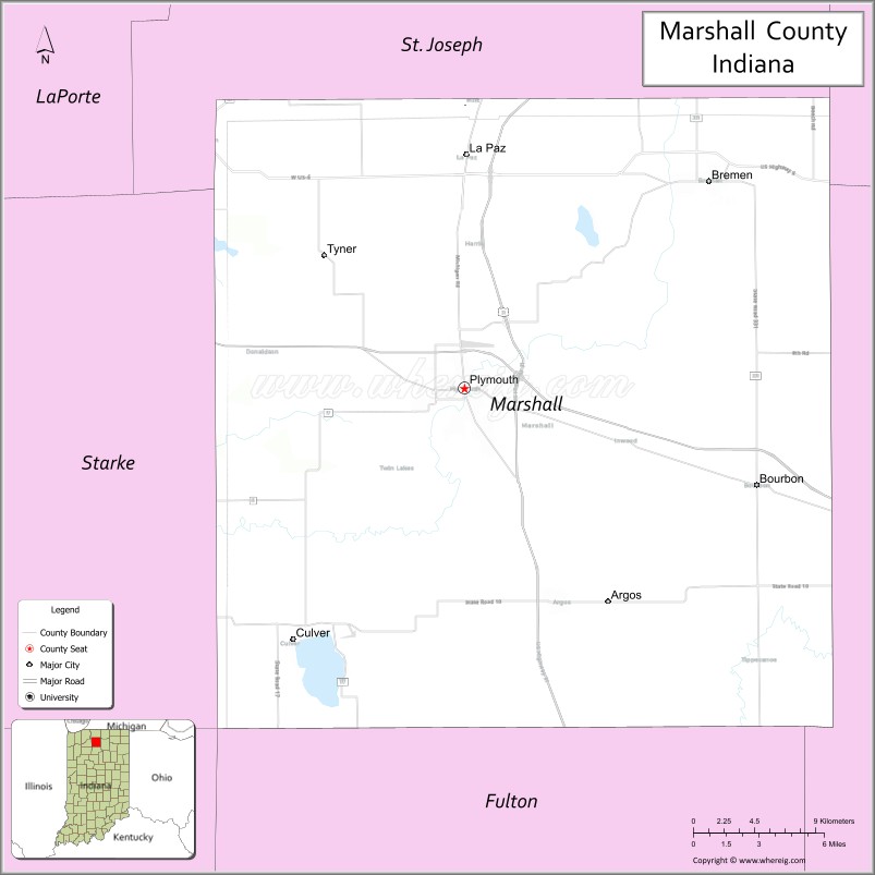
About Marshall County Map, Alabama: The map showing the county boundary, county seat, major cities, highways, water bodies and neighbouring counties.
Related Indiana Maps
About Marshall County, Indiana
Noble County is a county located in the U.S. state of Indiana. It`s county seat is Albion. As per 2020 census, the population of Noble County was 47227 and population density of Noble was square miles. According to the United States Census Bureau, the county has a total area of 411 sq mi (1,064 km2). Noble County was established on -23702.
Marshall County Facts
| Continent | North America |
| Country | United States |
| State | Indiana |
| County Seat | Plymouth |
| Largest City/Town | Plymouth |
| Established | 1836 |
| Total Area | 449 sq mi |
| Land Area | 443 sq mi |
| Water Area | 6.3 sq mi |
| Population | 46,095 (Census 2020) |
| Population Density | 104 people per sq mi |
| Time Zone | Eastern Time Zone (ET) |
| Major Highways | US-30, US-31, IN-10, IN-17, IN-106 |
| Neighboring Counties | St. Joseph County (north), Elkhart County (northeast), Kosciusko County (east), Fulton County (south), Pulaski County (southwest), Starke County (west) |
| Famous For | Lakes, agriculture, Blueberry Festival |
| Top Attractions | Lake Maxinkuckee, Blueberry Festival, Marshall County Museum |
| Official Website | https://www.co.marshall.in.us/ |
Cities and Towns in Marshall County, Indiana
- Plymouth (county seat) – 10,383 (Census 2020)
- Culver – 1,460 (Census 2020)
- Argos – 1,691 (Census 2020)
- Bremen (partly) – 4,559 (Census 2020)
- La Paz – 561 (Census 2020)
- Bourbon – 1,879 (Census 2020)
Roads and Highways in Marshall County, Indiana
Marshall County is served by major highways that connect it to northern Indiana and nearby regional cities.
- US Route 30 – east-west highway linking Plymouth to Warsaw and Valparaiso
- US Route 31 – north-south route connecting Plymouth to South Bend and Indianapolis
- Indiana State Road 10 – runs east-west linking Culver to Rochester
- Indiana State Road 17 – connects Plymouth to Culver and surrounding communities
- Indiana State Road 106 – connects Bremen to US-31
Neighboring Counties of Marshall County
- St. Joseph County (north)
- Elkhart County (northeast)
- Kosciusko County (east)
- Fulton County (south)
- Pulaski County (southwest)
- Starke County (west)
Top Attractions in Marshall County, Indiana
Marshall County offers lakes, festivals, and outdoor recreation in a scenic rural setting.
- Lake Maxinkuckee – one of Indiana’s largest natural lakes, popular for boating and fishing
- Marshall County Blueberry Festival – annual festival in Plymouth with food and entertainment
- Marshall County Museum – exhibits on local history and culture
- Culver Academies – historic campus near Lake Maxinkuckee
- Potato Creek State Park (nearby) – hiking, camping, and wildlife viewing
- Plymouth Downtown – historic area with shops and dining
Distance from Marshall County to Nearby Cities
- Marshall County to South Bend – 25 mi (40 km)
- Marshall County to Fort Wayne – 75 mi (121 km)
- Marshall County to Indianapolis – 120 mi (193 km)
- Marshall County to Chicago – 90 mi (145 km)
- Marshall County to Lafayette – 90 mi (145 km)
FAQs about Marshall County
Marshall County is located in northern Indiana.
The county seat is Plymouth, which is also the largest city in the county.
It is known for its lakes, agriculture, and the Blueberry Festival.
Yes, it is mostly rural with small towns and farmland.
The county is served by US-30, US-31, and several Indiana state roads.
- Adams County Map, IN
- Allen County Map, IN
- Bartholomew County Map, IN
- Benton County Map, IN
- Blackford County Map, IN
- Boone County Map, IN
- Brown County Map, IN
- Carroll County Map, IN
- Cass County Map, IN
- Clark County Map, IN
- Clay County Map, IN
- Clinton County Map, IN
- Crawford County Map, IN
- Daviess County Map, IN
- Dearborn County Map, IN
- Decatur County Map, IN
- DeKalb County Map, IN
- Delaware County Map, IN
- Dubois County Map, IN
- Elkhart County Map, IN
- Fayette County Map, IN
- Floyd County Map, IN
- Fountain County Map, IN
- Franklin County Map, IN
- Fulton County Map, IN
- Gibson County Map, IN
- Grant County Map, IN
- Greene County Map, IN
- Hamilton County Map, IN
- Hancock County Map, IN
- Harrison County Map, IN
- Hendricks County Map, IN
- Henry County Map, IN
- Howard County Map, IN
- Huntington County Map, IN
- Jackson County Map, IN
- Jasper County Map, IN
- Jay County Map, IN
- Jefferson County Map, IN
- Jennings County Map, IN
- Johnson County Map, IN
- Knox County Map, IN
- Kosciusko County Map, IN
- LaGrange County Map, IN
- Lake County Map, IN
- LaPorte County Map, IN
- Lawrence County Map, IN
- Madison County Map, IN
- Marion County Map, IN
- Marshall County Map, IN
- Martin County Map, IN
- Miami County Map, IN
- Monroe County Map, IN
- Montgomery County Map, IN
- Morgan County Map, IN
- Newton County Map, IN
- Noble County Map, IN
- Ohio County Map, IN
- Orange County Map, IN
- Owen County Map, IN
- Parke County Map, IN
- Perry County Map, IN
- Pike County Map, IN
- Porter County Map, IN
- Posey County Map, IN
- Pulaski County Map, IN
- Putnam County Map, IN
- Randolph County Map, IN
- Ripley County Map, IN
- Rush County Map, IN
- St Joseph County Map, IN
- Scott County Map, IN
- Shelby County Map, IN
- Spencer County Map, IN
- Starke County Map, IN
- Steuben County Map, IN
- Sullivan County Map, IN
- Switzerland County Map, IN
- Tippecanoe County Map, IN
- Tipton County Map, IN
- Union County Map, IN
- Vanderburgh County Map, IN
- Vermillion County Map, IN
- Vigo County Map, IN
- Wabash County Map, IN
- Warren County Map, IN
- Warrick County Map, IN
- Washington County Map, IN
- Wayne County Map, IN
- Wells County Map, IN
- White County Map, IN
- Whitley County Map, IN
- Alabama Counties
- Alaska boroughs
- Arizona Counties
- Arkansas Counties
- California County Map
- Colorado Counties
- Connecticut Counties
- Delaware Counties
- Florida County Map
- Georgia County Map
- Hawaii Counties
- Idaho Counties
- Illinois Counties
- Indiana Counties
- Iowa Counties
- Kansas Counties
- Kentucky Counties
- Louisiana Counties
- Maine Counties
- Maryland Counties
- Massachusetts Counties
- Michigan County Map
- Minnesota Counties
- Mississippi Counties
- Missouri Counties
- Montana Counties
- Nebraska Counties
- Nevada Counties
- New York Counties
- New Hampshire Counties
- New Jersey Counties
- New Mexico Counties
- North Carolina Counties
- North Dakota Counties
- Ohio County Map
- Oklahoma Counties
- Oregon Counties
- Pennsylvania Counties
- Rhode Island Counties
- South Carolina Counties
- South Dakota Counties
- Map of Tennessee
- Texas County Map
- Utah Counties
- Vermont Counties
- Virginia Counties
- Washington Counties
- West Virginia Counties
- Wisconsin Counties
- Wyoming Counties