By Whereig Editors, Reviewed by Mukesh Kumar| Updated On: May 02, 2026 | 20:16 ET
Map of Rush County - Rush County is a county located in the U.S. state of Indiana. Rush County Map showing cities, highways, important places and water bodies. Get Where is Rush County located in the map, major cities in Rush county, population, areas, and places of interest.
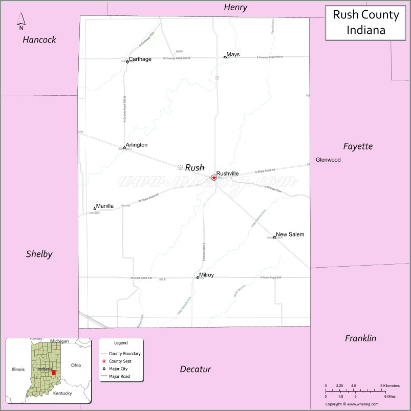
Map of Rush County, Indiana
About Rush County Map, North Dakota: The map showing the county boundary, county seat, major cities, highways, water bodies and neighbouring counties.
More North Dakota Maps & Info
About Rush County, Indiana
Sullivan County is a county located in the U.S. state of Indiana. It`s county seat is Sullivan. As per 2020 census, the population of Sullivan County was 20758 and population density of Sullivan was square miles. According to the United States Census Bureau, the county has a total area of 447 sq mi (1,158 km2). Sullivan County was established on -30315.
Rush County Facts
| Continent | North America |
| Country | United States |
| State | Indiana |
| County Seat | Rushville |
| Largest City/Town | Rushville |
| Established | 1822 |
| Total Area | 408 sq mi |
| Land Area | 408 sq mi |
| Water Area | 0.3 sq mi |
| Population | 16,752 (Census 2020) |
| Population Density | 41 people per sq mi |
| Time Zone | Eastern Time Zone (ET) |
| Major Highways | US-52, IN-3, IN-44, IN-103 |
| Neighboring Counties | Hancock County (north), Henry County (northeast), Fayette County (east), Decatur County (south), Shelby County (southwest), Johnson County (west) |
| Famous For | Rural landscapes, agriculture, Rushville |
| Top Attractions | Rush County Historical Society Museum, Riverside Park, Rushville Downtown |
| Official Website | https://rushcounty.in.gov/ |
Cities and Towns in Rush County, Indiana
- Rushville (county seat) – 6,208 (Census 2020)
- Carthage – 924 (Census 2020)
- Milroy – 604 (Census 2020)
- Arlington – 408 (Census 2020)
Roads and Highways in Rush County, Indiana
Rush County is served by highways that connect it to east-central Indiana and surrounding regions.
- US Route 52 – runs through Rushville connecting the county to Indianapolis and Cincinnati
- Indiana State Road 3 – north-south route linking Rushville to New Castle and Greensburg
- Indiana State Road 44 – east-west route connecting Rushville to Shelbyville and Connersville
- Indiana State Road 103 – connects the county to nearby communities
Neighboring Counties of Rush County
- Hancock County (north)
- Henry County (northeast)
- Fayette County (east)
- Decatur County (south)
- Shelby County (southwest)
- Johnson County (west)
Top Attractions in Rush County, Indiana
Rush County offers small-town charm, parks, and local history.
- Rush County Historical Society Museum – exhibits on local heritage
- Riverside Park – park with trails, playgrounds, and river access
- Rushville Downtown – historic district with shops and dining
- Milroy Community Park – recreational facilities and events
- Carthage Historic Area – small-town charm with historic buildings
- Flatrock River – scenic river for outdoor activities
Distance from Rush County to Nearby Cities
- Rush County to Indianapolis – 40 mi (64 km)
- Rush County to Cincinnati – 90 mi (145 km)
- Rush County to Columbus – 50 mi (80 km)
- Rush County to Louisville – 110 mi (177 km)
- Rush County to Dayton – 80 mi (129 km)
FAQs about Rush County
Rush County is located in east-central Indiana.
The county seat is Rushville, which is also the largest city in the county.
It is known for agriculture, rural landscapes, and small-town communities.
Yes, it is mostly rural with farmland and small towns.
The county is served by US-52 and several Indiana state roads.
- Adams County Map
- Barnes County Map
- Benson County Map
- Billings County Map
- Bottineau County Map
- Bowman County Map
- Burke County Map
- Burleigh County Map
- Cass County Map
- Cavalier County Map
- Dickey County Map
- Divide County Map
- Dunn County Map
- Eddy County Map
- Emmons County Map
- Foster County Map
- Golden Valley County Map
- Grand Forks County Map
- Grant County Map
- Griggs County Map
- Hettinger County Map
- Kidder County Map
- LaMoure County Map
- Logan County Map
- McHenry County Map
- McKenzie County Map
- McLean County Map
- McIntosh County Map
- Mercer County Map
- Morton County Map
- Mountrail County Map
- Nelson County Map
- Oliver County Map
- Pembina County Map
- Pierce County Map
- Ramsey County Map
- Ransom County Map
- Renville County Map
- Richland County Map
- Rolette County Map
- Sargent County Map
- Sheridan County Map
- Sioux County Map
- Slope County Map
- Stark County Map
- Steele County Map
- Stutsman County Map
- Towner County Map
- Traill County Map
- Walsh County Map
- Ward County Map
- Wells County Map
- Williams County Map
- Adams County Map, IN
- Allen County Map, IN
- Bartholomew County Map, IN
- Benton County Map, IN
- Blackford County Map, IN
- Boone County Map, IN
- Brown County Map, IN
- Carroll County Map, IN
- Cass County Map, IN
- Clark County Map, IN
- Clay County Map, IN
- Clinton County Map, IN
- Crawford County Map, IN
- Daviess County Map, IN
- Dearborn County Map, IN
- Decatur County Map, IN
- DeKalb County Map, IN
- Delaware County Map, IN
- Dubois County Map, IN
- Elkhart County Map, IN
- Fayette County Map, IN
- Floyd County Map, IN
- Fountain County Map, IN
- Franklin County Map, IN
- Fulton County Map, IN
- Gibson County Map, IN
- Grant County Map, IN
- Greene County Map, IN
- Hamilton County Map, IN
- Hancock County Map, IN
- Harrison County Map, IN
- Hendricks County Map, IN
- Henry County Map, IN
- Howard County Map, IN
- Huntington County Map, IN
- Jackson County Map, IN
- Jasper County Map, IN
- Jay County Map, IN
- Jefferson County Map, IN
- Jennings County Map, IN
- Johnson County Map, IN
- Knox County Map, IN
- Kosciusko County Map, IN
- LaGrange County Map, IN
- Lake County Map, IN
- LaPorte County Map, IN
- Lawrence County Map, IN
- Madison County Map, IN
- Marion County Map, IN
- Marshall County Map, IN
- Martin County Map, IN
- Miami County Map, IN
- Monroe County Map, IN
- Montgomery County Map, IN
- Morgan County Map, IN
- Newton County Map, IN
- Noble County Map, IN
- Ohio County Map, IN
- Orange County Map, IN
- Owen County Map, IN
- Parke County Map, IN
- Perry County Map, IN
- Pike County Map, IN
- Porter County Map, IN
- Posey County Map, IN
- Pulaski County Map, IN
- Putnam County Map, IN
- Randolph County Map, IN
- Ripley County Map, IN
- Rush County Map, IN
- St Joseph County Map, IN
- Scott County Map, IN
- Shelby County Map, IN
- Spencer County Map, IN
- Starke County Map, IN
- Steuben County Map, IN
- Sullivan County Map, IN
- Switzerland County Map, IN
- Tippecanoe County Map, IN
- Tipton County Map, IN
- Union County Map, IN
- Vanderburgh County Map, IN
- Vermillion County Map, IN
- Vigo County Map, IN
- Wabash County Map, IN
- Warren County Map, IN
- Warrick County Map, IN
- Washington County Map, IN
- Wayne County Map, IN
- Wells County Map, IN
- White County Map, IN
- Whitley County Map, IN
- Alabama Counties
- Alaska boroughs
- Arizona Counties
- Arkansas Counties
- California County Map
- Colorado Counties
- Connecticut Counties
- Delaware Counties
- Florida County Map
- Georgia County Map
- Hawaii Counties
- Idaho Counties
- Illinois Counties
- Indiana Counties
- Iowa Counties
- Kansas Counties
- Kentucky Counties
- Louisiana Counties
- Maine Counties
- Maryland Counties
- Massachusetts Counties
- Michigan County Map
- Minnesota Counties
- Mississippi Counties
- Missouri Counties
- Montana Counties
- Nebraska Counties
- Nevada Counties
- New York Counties
- New Hampshire Counties
- New Jersey Counties
- New Mexico Counties
- North Carolina Counties
- North Dakota Counties
- Ohio County Map
- Oklahoma Counties
- Oregon Counties
- Pennsylvania Counties
- Rhode Island Counties
- South Carolina Counties
- South Dakota Counties
- Map of Tennessee
- Texas County Map
- Utah Counties
- Vermont Counties
- Virginia Counties
- Washington Counties
- West Virginia Counties
- Wisconsin Counties
- Wyoming Counties