By Whereig Editors, Reviewed by Mukesh Kumar| Updated On: May 02, 2026 | 20:16 ET
Map of Bartholomew County - Bartholomew County is a county located in the U.S. state of Indiana. Bartholomew County Map showing cities, highways, important places and water bodies. Get Where is Bartholomew County located in the map, major cities in Bartholomew county, population, areas, and places of interest.
Map of Bartholomew County, Indiana
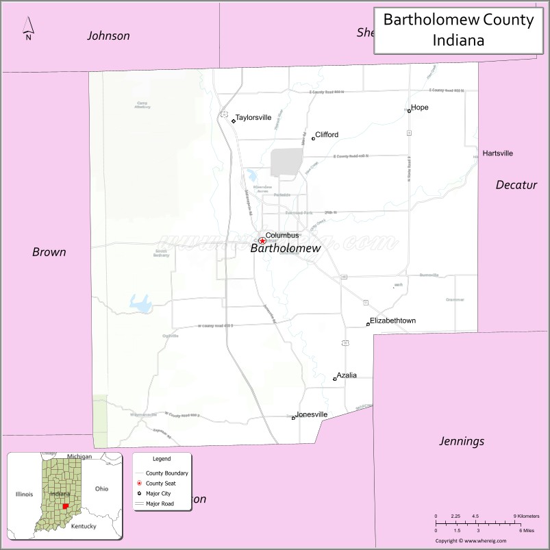
About Bartholomew County Map, Alabama: The map showing the county boundary, county seat, major cities, highways, water bodies and neighbouring counties.
Related Indiana Maps
About Bartholomew County, Indiana
Clark County is a county located in the U.S. state of Indiana. It`s county seat is Jeffersonville. As per 2020 census, the population of Clark County was 122738 and population density of Clark was square miles. According to the United States Census Bureau, the county has a total area of 373 sq mi (966 km2). Clark County was established on -36124.
Bartholomew County Facts
| Continent | North America |
| Country | United States |
| State | Indiana |
| County Seat | Columbus |
| Largest City/Town | Columbus |
| Established | 1821 |
| Total Area | 409 sq mi |
| Land Area | 406 sq mi |
| Water Area | 3.3 sq mi |
| Population | 82,208 (Census 2020) |
| Population Density | 202 people per sq mi |
| Time Zone | Eastern Time Zone (ET) |
| Major Highways | I-65, US-31, IN-7, IN-9, IN-11, IN-46, IN-58 |
| Neighboring Counties | Johnson County (north), Shelby County (northeast), Decatur County (east), Jennings County (southeast), Jackson County (south), Brown County (west) |
| Famous For | Modern architecture, Cummins Inc., Columbus landmarks |
| Top Attractions | Mill Race Park, Zaharakos Ice Cream Parlor, architectural tours |
| Official Website | https://www.bartholomew.in.gov/ |
Cities and Towns in Bartholomew County, Indiana
- Columbus (county seat) – 50,474 (Census 2020)
- Hope – 2,137 (Census 2020)
- Clifford – 197 (Census 2020)
- Hartsville – 362 (Census 2020)
- Elizabethtown – 504 (Census 2020)
Roads and Highways in Bartholomew County, Indiana
Bartholomew County has a well-developed road network that connects Columbus to major cities across Indiana and neighboring states.
- Interstate 65 (I-65) – north-south route connecting Indianapolis to Louisville
- US Route 31 – runs parallel to I-65 linking Columbus to Indianapolis and southern Indiana
- Indiana State Road 7 – connects Columbus to Jennings County and beyond
- Indiana State Road 9 – north-south route linking Hope to Shelby County
- Indiana State Road 11 – connects Columbus to Jackson County
- Indiana State Road 46 – major east-west route across the county
- Indiana State Road 58 – connects Columbus to Seymour and eastern areas
Neighboring Counties of Bartholomew County
- Johnson County (north)
- Shelby County (northeast)
- Decatur County (east)
- Jennings County (southeast)
- Jackson County (south)
- Brown County (west)
Top Attractions in Bartholomew County, Indiana
Bartholomew County is known for its unique architecture and vibrant community spaces, especially in the city of Columbus.
- Mill Race Park – scenic park with trails, river views, and iconic structures
- Zaharakos Ice Cream Parlor – historic soda fountain and museum
- Columbus Architecture Tours – guided tours of modern architectural landmarks
- Kidscommons – interactive children’s museum
- Brown County State Park – nearby park with hiking and nature views
- Bartholomew County Historical Society Museum – local history exhibits
- Donner Park – popular park with sports and recreation facilities
Distance from Bartholomew County to Nearby Cities
- Bartholomew County to Indianapolis – 45 mi (72 km)
- Bartholomew County to Louisville – 75 mi (121 km)
- Bartholomew County to Cincinnati – 95 mi (153 km)
- Bartholomew County to Bloomington – 35 mi (56 km)
- Bartholomew County to Chicago – 200 mi (322 km)
FAQs about Bartholomew County
Bartholomew County is located in south-central Indiana.
The county seat is Columbus, which is also the largest city.
It is widely known for its modern architecture and the city of Columbus.
Yes, it has steady growth due to industry, architecture tourism, and quality of life.
The county is served by I-65, US-31, and several Indiana state roads including IN-46 and IN-58.
- Adams County Map, IN
- Allen County Map, IN
- Bartholomew County Map, IN
- Benton County Map, IN
- Blackford County Map, IN
- Boone County Map, IN
- Brown County Map, IN
- Carroll County Map, IN
- Cass County Map, IN
- Clark County Map, IN
- Clay County Map, IN
- Clinton County Map, IN
- Crawford County Map, IN
- Daviess County Map, IN
- Dearborn County Map, IN
- Decatur County Map, IN
- DeKalb County Map, IN
- Delaware County Map, IN
- Dubois County Map, IN
- Elkhart County Map, IN
- Fayette County Map, IN
- Floyd County Map, IN
- Fountain County Map, IN
- Franklin County Map, IN
- Fulton County Map, IN
- Gibson County Map, IN
- Grant County Map, IN
- Greene County Map, IN
- Hamilton County Map, IN
- Hancock County Map, IN
- Harrison County Map, IN
- Hendricks County Map, IN
- Henry County Map, IN
- Howard County Map, IN
- Huntington County Map, IN
- Jackson County Map, IN
- Jasper County Map, IN
- Jay County Map, IN
- Jefferson County Map, IN
- Jennings County Map, IN
- Johnson County Map, IN
- Knox County Map, IN
- Kosciusko County Map, IN
- LaGrange County Map, IN
- Lake County Map, IN
- LaPorte County Map, IN
- Lawrence County Map, IN
- Madison County Map, IN
- Marion County Map, IN
- Marshall County Map, IN
- Martin County Map, IN
- Miami County Map, IN
- Monroe County Map, IN
- Montgomery County Map, IN
- Morgan County Map, IN
- Newton County Map, IN
- Noble County Map, IN
- Ohio County Map, IN
- Orange County Map, IN
- Owen County Map, IN
- Parke County Map, IN
- Perry County Map, IN
- Pike County Map, IN
- Porter County Map, IN
- Posey County Map, IN
- Pulaski County Map, IN
- Putnam County Map, IN
- Randolph County Map, IN
- Ripley County Map, IN
- Rush County Map, IN
- St Joseph County Map, IN
- Scott County Map, IN
- Shelby County Map, IN
- Spencer County Map, IN
- Starke County Map, IN
- Steuben County Map, IN
- Sullivan County Map, IN
- Switzerland County Map, IN
- Tippecanoe County Map, IN
- Tipton County Map, IN
- Union County Map, IN
- Vanderburgh County Map, IN
- Vermillion County Map, IN
- Vigo County Map, IN
- Wabash County Map, IN
- Warren County Map, IN
- Warrick County Map, IN
- Washington County Map, IN
- Wayne County Map, IN
- Wells County Map, IN
- White County Map, IN
- Whitley County Map, IN
- Alabama Counties
- Alaska boroughs
- Arizona Counties
- Arkansas Counties
- California County Map
- Colorado Counties
- Connecticut Counties
- Delaware Counties
- Florida County Map
- Georgia County Map
- Hawaii Counties
- Idaho Counties
- Illinois Counties
- Indiana Counties
- Iowa Counties
- Kansas Counties
- Kentucky Counties
- Louisiana Counties
- Maine Counties
- Maryland Counties
- Massachusetts Counties
- Michigan County Map
- Minnesota Counties
- Mississippi Counties
- Missouri Counties
- Montana Counties
- Nebraska Counties
- Nevada Counties
- New York Counties
- New Hampshire Counties
- New Jersey Counties
- New Mexico Counties
- North Carolina Counties
- North Dakota Counties
- Ohio County Map
- Oklahoma Counties
- Oregon Counties
- Pennsylvania Counties
- Rhode Island Counties
- South Carolina Counties
- South Dakota Counties
- Map of Tennessee
- Texas County Map
- Utah Counties
- Vermont Counties
- Virginia Counties
- Washington Counties
- West Virginia Counties
- Wisconsin Counties
- Wyoming Counties