By Whereig Editors, Reviewed by Mukesh Kumar| Updated On: May 02, 2026 | 20:16 ET
Map of Noble County - Noble County is a county located in the U.S. state of Indiana. Noble County Map showing cities, highways, important places and water bodies. Get Where is Noble County located in the map, major cities in Noble county, population, areas, and places of interest.
Map of Noble County, Indiana
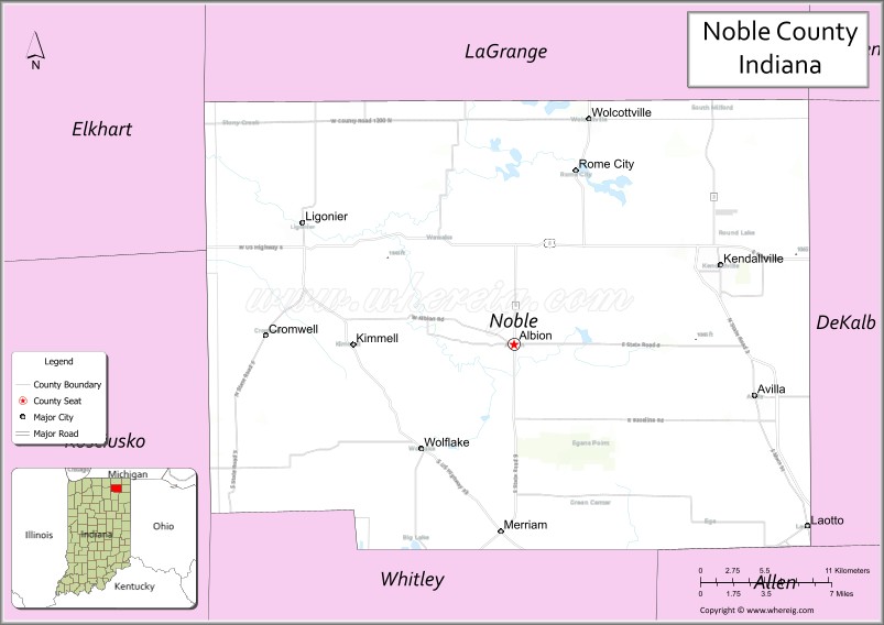
About Noble County Map, Alabama: The map showing the county boundary, county seat, major cities, highways, water bodies and neighbouring counties.
Related Indiana Maps
About Noble County, Indiana
Porter County is a county located in the U.S. state of Indiana. It`s county seat is Valparaiso. As per 2020 census, the population of Porter County was 174243 and population density of Porter was square miles. According to the United States Census Bureau, the county has a total area of 418 sq mi (1,083 km2). Porter County was established on -23702.
Noble County Facts
| Continent | North America |
| Country | United States |
| State | Indiana |
| County Seat | Albion |
| Largest City/Town | Kendallville |
| Established | 1836 |
| Total Area | 417 sq mi |
| Land Area | 411 sq mi |
| Water Area | 5.7 sq mi |
| Population | 47,457 (Census 2020) |
| Population Density | 115 people per sq mi |
| Time Zone | Eastern Time Zone (ET) |
| Major Highways | US-6, US-33, IN-3, IN-5, IN-8, IN-9 |
| Neighboring Counties | LaGrange County (north), Steuben County (northeast), DeKalb County (east), Allen County (south), Whitley County (southwest), Kosciusko County (west) |
| Famous For | Lakes, Kendallville, outdoor recreation |
| Top Attractions | Chain O'Lakes State Park, Bixler Lake Park, Mid-America Windmill Museum |
| Official Website | https://noblecounty.in.gov/ |
Cities and Towns in Noble County, Indiana
- Kendallville – 9,921 (Census 2020)
- Albion (county seat) – 2,349 (Census 2020)
- Ligonier – 4,826 (Census 2020)
- Avilla – 2,401 (Census 2020)
- Rome City – 1,424 (Census 2020)
- Cromwell – 528 (Census 2020)
- Wawaka – 242 (Census 2020)
Roads and Highways in Noble County, Indiana
Noble County is served by several highways that connect it to northeastern Indiana and surrounding regions.
- US Route 6 – east-west highway linking Kendallville to Nappanee and Butler
- US Route 33 – connects Ligonier to Fort Wayne and Elkhart
- Indiana State Road 3 – north-south route linking Kendallville to Fort Wayne and South Bend
- Indiana State Road 5 – connects Ligonier to Shipshewana and Huntington
- Indiana State Road 8 – east-west route linking Albion to Auburn and Knox
- Indiana State Road 9 – runs north-south connecting the county to Columbia City and Huntington
Neighboring Counties of Noble County
- LaGrange County (north)
- Steuben County (northeast)
- DeKalb County (east)
- Allen County (south)
- Whitley County (southwest)
- Kosciusko County (west)
Top Attractions in Noble County, Indiana
Noble County offers lakes, parks, and family-friendly attractions.
- Chain O'Lakes State Park – scenic park with lakes, trails, and boating
- Bixler Lake Park – recreational park with fishing and walking trails
- Mid-America Windmill Museum – displays historic windmills and exhibits
- Rome City Lakes – popular area for boating and fishing
- Kendallville Downtown – shops, dining, and local events
- Gene Stratton-Porter State Historic Site (nearby) – historic home and nature preserve
Distance from Noble County to Nearby Cities
- Noble County to Fort Wayne – 25 mi (40 km)
- Noble County to South Bend – 60 mi (97 km)
- Noble County to Indianapolis – 130 mi (209 km)
- Noble County to Chicago – 140 mi (225 km)
- Noble County to Toledo – 120 mi (193 km)
FAQs about Noble County
Noble County is located in northeastern Indiana.
The county seat is Albion, while Kendallville is the largest city.
It is known for its lakes, outdoor recreation, and small-town communities.
Yes, it has many lakes that attract visitors for recreation.
The county is served by US-6, US-33, and several Indiana state roads.
- Adams County Map, IN
- Allen County Map, IN
- Bartholomew County Map, IN
- Benton County Map, IN
- Blackford County Map, IN
- Boone County Map, IN
- Brown County Map, IN
- Carroll County Map, IN
- Cass County Map, IN
- Clark County Map, IN
- Clay County Map, IN
- Clinton County Map, IN
- Crawford County Map, IN
- Daviess County Map, IN
- Dearborn County Map, IN
- Decatur County Map, IN
- DeKalb County Map, IN
- Delaware County Map, IN
- Dubois County Map, IN
- Elkhart County Map, IN
- Fayette County Map, IN
- Floyd County Map, IN
- Fountain County Map, IN
- Franklin County Map, IN
- Fulton County Map, IN
- Gibson County Map, IN
- Grant County Map, IN
- Greene County Map, IN
- Hamilton County Map, IN
- Hancock County Map, IN
- Harrison County Map, IN
- Hendricks County Map, IN
- Henry County Map, IN
- Howard County Map, IN
- Huntington County Map, IN
- Jackson County Map, IN
- Jasper County Map, IN
- Jay County Map, IN
- Jefferson County Map, IN
- Jennings County Map, IN
- Johnson County Map, IN
- Knox County Map, IN
- Kosciusko County Map, IN
- LaGrange County Map, IN
- Lake County Map, IN
- LaPorte County Map, IN
- Lawrence County Map, IN
- Madison County Map, IN
- Marion County Map, IN
- Marshall County Map, IN
- Martin County Map, IN
- Miami County Map, IN
- Monroe County Map, IN
- Montgomery County Map, IN
- Morgan County Map, IN
- Newton County Map, IN
- Noble County Map, IN
- Ohio County Map, IN
- Orange County Map, IN
- Owen County Map, IN
- Parke County Map, IN
- Perry County Map, IN
- Pike County Map, IN
- Porter County Map, IN
- Posey County Map, IN
- Pulaski County Map, IN
- Putnam County Map, IN
- Randolph County Map, IN
- Ripley County Map, IN
- Rush County Map, IN
- St Joseph County Map, IN
- Scott County Map, IN
- Shelby County Map, IN
- Spencer County Map, IN
- Starke County Map, IN
- Steuben County Map, IN
- Sullivan County Map, IN
- Switzerland County Map, IN
- Tippecanoe County Map, IN
- Tipton County Map, IN
- Union County Map, IN
- Vanderburgh County Map, IN
- Vermillion County Map, IN
- Vigo County Map, IN
- Wabash County Map, IN
- Warren County Map, IN
- Warrick County Map, IN
- Washington County Map, IN
- Wayne County Map, IN
- Wells County Map, IN
- White County Map, IN
- Whitley County Map, IN
- Alabama Counties
- Alaska boroughs
- Arizona Counties
- Arkansas Counties
- California County Map
- Colorado Counties
- Connecticut Counties
- Delaware Counties
- Florida County Map
- Georgia County Map
- Hawaii Counties
- Idaho Counties
- Illinois Counties
- Indiana Counties
- Iowa Counties
- Kansas Counties
- Kentucky Counties
- Louisiana Counties
- Maine Counties
- Maryland Counties
- Massachusetts Counties
- Michigan County Map
- Minnesota Counties
- Mississippi Counties
- Missouri Counties
- Montana Counties
- Nebraska Counties
- Nevada Counties
- New York Counties
- New Hampshire Counties
- New Jersey Counties
- New Mexico Counties
- North Carolina Counties
- North Dakota Counties
- Ohio County Map
- Oklahoma Counties
- Oregon Counties
- Pennsylvania Counties
- Rhode Island Counties
- South Carolina Counties
- South Dakota Counties
- Map of Tennessee
- Texas County Map
- Utah Counties
- Vermont Counties
- Virginia Counties
- Washington Counties
- West Virginia Counties
- Wisconsin Counties
- Wyoming Counties