By Whereig Editors, Reviewed by Mukesh Kumar| Updated On: May 02, 2026 | 20:16 ET
Map of Whitley County - Whitley County is a county located in the U.S. state of Indiana. Whitley County Map showing cities, highways, important places and water bodies. Get Where is Whitley County located in the map, major cities in Whitley county, population, areas, and places of interest.
Map of Whitley County, Indiana
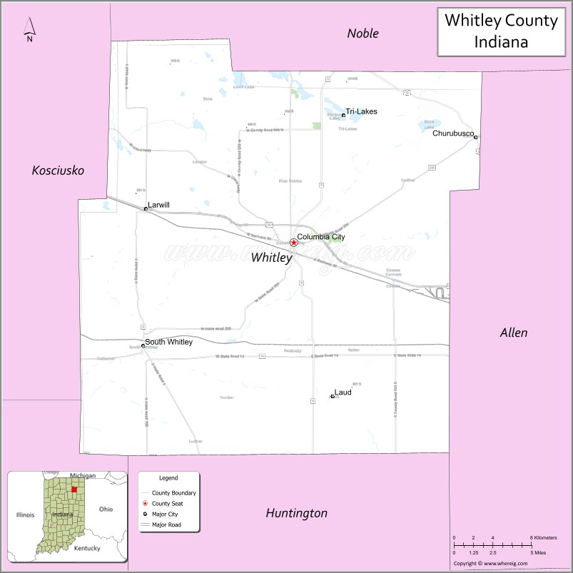
About Whitley County Map, Alabama: The map showing the county boundary, county seat, major cities, highways, water bodies and neighbouring counties.
Related Indiana Maps
About Whitley County, Indiana
Black Hawk County is a county located in the U.S. state of Iowa. It`s county seat is Waterloo. As per 2020 census, the population of Black Hawk County was 130368 and population density of Black Hawk was square miles. According to the United States Census Bureau, the county has a total area of 567 sq mi (1,469 km2). Black Hawk County was established on -20770.
Whitley County Facts
| Continent | North America |
| Country | United States |
| State | Indiana |
| County Seat | Columbia City |
| Largest City/Town | Columbia City |
| Established | 1835 |
| Total Area | 337 sq mi (873 sq km) |
| Land Area | 335 sq mi (868 sq km) |
| Water Area | 2.3 sq mi (6 sq km) |
| Population | 34,112 (Census 2020) |
| Population Density | 102 people per sq mi |
| Time Zone | Eastern Time Zone (ET) |
| Major Highways | US-30, SR-5, SR-9, SR-14, SR-205 |
| Neighboring Counties | Elkhart County, Noble County, Allen County, Huntington County, Kosciusko County (IN) |
| Famous For | Blue River, rural landscapes, Columbia City charm |
| Top Attractions | Morsches Park, Whitley County Historical Museum, Blue River Trail, Eagle Glen Golf Club |
| Official Website | https://www.whitleygov.com |
Cities and Towns in Whitley County, Indiana
- Columbia City (county seat) – 9,892 (Census 2020)
- Churubusco – 2,049 (Census 2020)
- Larwill – 278 (Census 2020)
- South Whitley – 1,694 (Census 2020)
Roads and Highways in Whitley County, Indiana
Whitley County is connected by major highways that provide access to Fort Wayne and other parts of northern Indiana.
- U.S. Route 30 – major east-west highway connecting to Fort Wayne and Warsaw
- State Road 5 – north-south route linking local towns
- State Road 9 – connects Columbia City to Huntington and Auburn
- State Road 14 – runs east-west through the county
- State Road 205 – provides regional connections within the county
Neighboring Counties of Whitley County
- Noble County (north)
- Allen County (east)
- Huntington County (south)
- Kosciusko County (west)
- Elkhart County (northwest)
Top Attractions in Whitley County, Indiana
The county offers a mix of parks, outdoor recreation, and small-town attractions centered around Columbia City.
- Morsches Park – a large park with trails, playgrounds, and a lake
- Whitley County Historical Museum – exhibits highlighting local history
- Blue River Trail – a scenic trail for walking and biking
- Eagle Glen Golf Club – a popular golf course with well-kept greens
- Tri-Lakes – nearby lakes offering boating and fishing opportunities
- Downtown Columbia City – features local shops and restaurants
- Collamer Covered Bridge (nearby) – a historic and picturesque bridge
Distance from Whitley County to Nearby Cities
- Columbia City to Fort Wayne – 20 mi (32 km)
- Columbia City to Warsaw – 25 mi (40 km)
- Columbia City to South Bend – 70 mi (113 km)
- Columbia City to Indianapolis – 115 mi (185 km)
- Columbia City to Chicago – 140 mi (225 km)
FAQs about Whitley County
It is located in northeastern Indiana, west of Fort Wayne.
Columbia City is the county seat and largest city.
It is known for its parks, Blue River, and small-town charm.
Whitley County follows the Eastern Time Zone.
Main routes include U.S. Route 30 and State Roads 5, 9, 14, and 205.
- Adams County Map, IN
- Allen County Map, IN
- Bartholomew County Map, IN
- Benton County Map, IN
- Blackford County Map, IN
- Boone County Map, IN
- Brown County Map, IN
- Carroll County Map, IN
- Cass County Map, IN
- Clark County Map, IN
- Clay County Map, IN
- Clinton County Map, IN
- Crawford County Map, IN
- Daviess County Map, IN
- Dearborn County Map, IN
- Decatur County Map, IN
- DeKalb County Map, IN
- Delaware County Map, IN
- Dubois County Map, IN
- Elkhart County Map, IN
- Fayette County Map, IN
- Floyd County Map, IN
- Fountain County Map, IN
- Franklin County Map, IN
- Fulton County Map, IN
- Gibson County Map, IN
- Grant County Map, IN
- Greene County Map, IN
- Hamilton County Map, IN
- Hancock County Map, IN
- Harrison County Map, IN
- Hendricks County Map, IN
- Henry County Map, IN
- Howard County Map, IN
- Huntington County Map, IN
- Jackson County Map, IN
- Jasper County Map, IN
- Jay County Map, IN
- Jefferson County Map, IN
- Jennings County Map, IN
- Johnson County Map, IN
- Knox County Map, IN
- Kosciusko County Map, IN
- LaGrange County Map, IN
- Lake County Map, IN
- LaPorte County Map, IN
- Lawrence County Map, IN
- Madison County Map, IN
- Marion County Map, IN
- Marshall County Map, IN
- Martin County Map, IN
- Miami County Map, IN
- Monroe County Map, IN
- Montgomery County Map, IN
- Morgan County Map, IN
- Newton County Map, IN
- Noble County Map, IN
- Ohio County Map, IN
- Orange County Map, IN
- Owen County Map, IN
- Parke County Map, IN
- Perry County Map, IN
- Pike County Map, IN
- Porter County Map, IN
- Posey County Map, IN
- Pulaski County Map, IN
- Putnam County Map, IN
- Randolph County Map, IN
- Ripley County Map, IN
- Rush County Map, IN
- St Joseph County Map, IN
- Scott County Map, IN
- Shelby County Map, IN
- Spencer County Map, IN
- Starke County Map, IN
- Steuben County Map, IN
- Sullivan County Map, IN
- Switzerland County Map, IN
- Tippecanoe County Map, IN
- Tipton County Map, IN
- Union County Map, IN
- Vanderburgh County Map, IN
- Vermillion County Map, IN
- Vigo County Map, IN
- Wabash County Map, IN
- Warren County Map, IN
- Warrick County Map, IN
- Washington County Map, IN
- Wayne County Map, IN
- Wells County Map, IN
- White County Map, IN
- Whitley County Map, IN
- Alabama Counties
- Alaska boroughs
- Arizona Counties
- Arkansas Counties
- California County Map
- Colorado Counties
- Connecticut Counties
- Delaware Counties
- Florida County Map
- Georgia County Map
- Hawaii Counties
- Idaho Counties
- Illinois Counties
- Indiana Counties
- Iowa Counties
- Kansas Counties
- Kentucky Counties
- Louisiana Counties
- Maine Counties
- Maryland Counties
- Massachusetts Counties
- Michigan County Map
- Minnesota Counties
- Mississippi Counties
- Missouri Counties
- Montana Counties
- Nebraska Counties
- Nevada Counties
- New York Counties
- New Hampshire Counties
- New Jersey Counties
- New Mexico Counties
- North Carolina Counties
- North Dakota Counties
- Ohio County Map
- Oklahoma Counties
- Oregon Counties
- Pennsylvania Counties
- Rhode Island Counties
- South Carolina Counties
- South Dakota Counties
- Map of Tennessee
- Texas County Map
- Utah Counties
- Vermont Counties
- Virginia Counties
- Washington Counties
- West Virginia Counties
- Wisconsin Counties
- Wyoming Counties