By Whereig Editors, Reviewed by Mukesh Kumar| Updated On: May 02, 2026 | 20:16 ET
Map of Allen County - Allen County is a county located in the U.S. state of Indiana. Allen County Map showing cities, highways, important places and water bodies. Get Where is Allen County located in the map, major cities in Allen county, population, areas, and places of interest.
Map of Allen County, Indiana
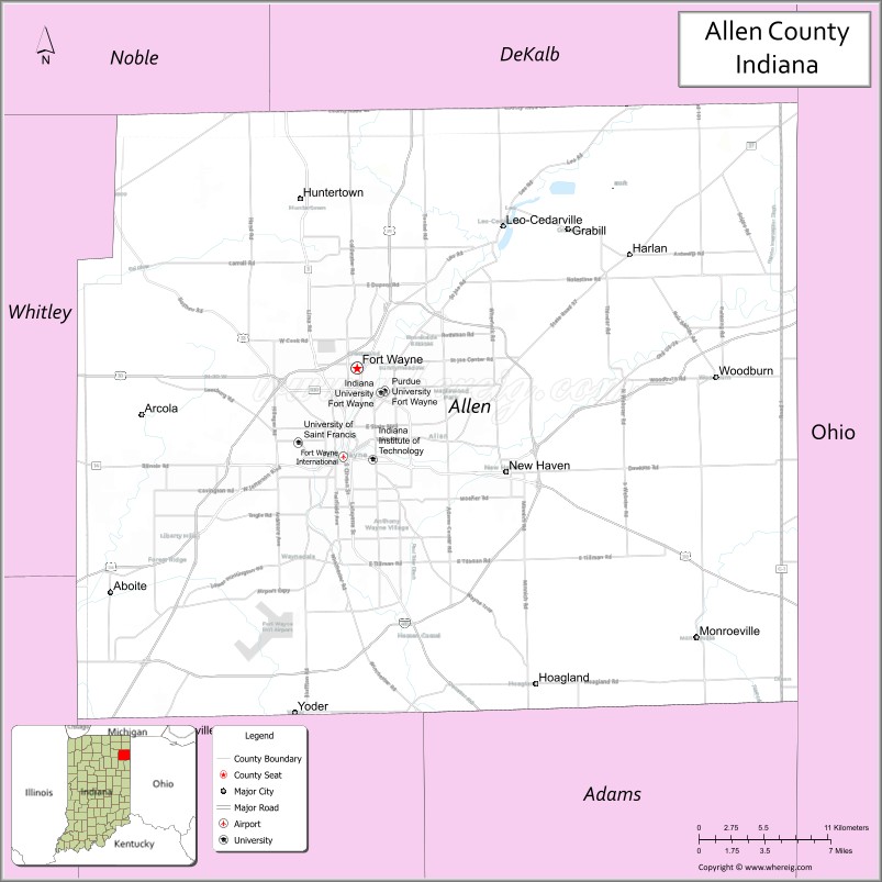
About Allen County Map, Alabama: The map showing the county boundary, county seat, major cities, highways, water bodies and neighbouring counties.
Related Indiana Maps
About Allen County, Indiana
Cass County is a county located in the U.S. state of Indiana. It`s county seat is Logansport. As per 2020 census, the population of Cass County was 37563 and population density of Cass was square miles. According to the United States Census Bureau, the county has a total area of 412 sq mi (1,067 km2). Cass County was established on -25944.
Allen County Facts
| Continent | North America |
| Country | United States |
| State | Indiana |
| County Seat | Fort Wayne |
| Largest City/Town | Fort Wayne |
| Established | 1823 |
| Total Area | 660 sq mi |
| Land Area | 657 sq mi |
| Water Area | 3.3 sq mi |
| Population | 385,410 (Census 2020) |
| Population Density | 587 people per sq mi |
| Time Zone | Eastern Time Zone (ET) |
| Major Highways | I-69, US-24, US-27, US-30, IN-1, IN-3, IN-14, IN-37, IN-930 |
| Neighboring Counties | DeKalb County (north), Defiance County, OH (northeast), Paulding County, OH (east), Van Wert County, OH (southeast), Adams County (south), Wells County (southwest), Huntington County (west), Whitley County (northwest) |
| Famous For | Fort Wayne, manufacturing, healthcare, cultural attractions |
| Top Attractions | Fort Wayne Children's Zoo, Foellinger-Freimann Botanical Conservatory, Parkview Field |
| Official Website | https://allencounty.in.gov/ |
Cities and Towns in Allen County, Indiana
- Fort Wayne (county seat) – 263,886 (Census 2020)
- New Haven – 15,577 (Census 2020)
- Woodburn – 1,692 (Census 2020)
- Monroeville – 1,235 (Census 2020)
- Grabill – 1,053 (Census 2020)
- Leo-Cedarville – 3,822 (Census 2020)
- Huntertown – 8,860 (Census 2020)
Roads and Highways in Allen County, Indiana
Allen County has a strong transportation network centered around Fort Wayne, making it a key regional hub for travel and commerce in northeastern Indiana.
- Interstate 69 (I-69) – north-south interstate connecting Fort Wayne to Indianapolis and Michigan
- US Route 24 – east-west route linking Fort Wayne to Ohio and western Indiana
- US Route 27 – runs north-south through Fort Wayne toward Michigan and Ohio
- US Route 30 – major east-west corridor connecting to Chicago and Ohio
- Indiana State Road 1 – connects Fort Wayne to southern Indiana towns
- Indiana State Road 3 – runs north-south through eastern Allen County
- Indiana State Road 14 – connects Fort Wayne to rural western areas
- Indiana State Road 37 – links Fort Wayne to Indianapolis
- Indiana State Road 930 – bypass route around Fort Wayne
Neighboring Counties of Allen County
- DeKalb County (north)
- Defiance County, Ohio (northeast)
- Paulding County, Ohio (east)
- Van Wert County, Ohio (southeast)
- Adams County (south)
- Wells County (southwest)
- Huntington County (west)
- Whitley County (northwest)
Top Attractions in Allen County, Indiana
Allen County offers a mix of family-friendly attractions, cultural sites, and outdoor spaces centered around Fort Wayne.
- Fort Wayne Children's Zoo – one of the top-ranked zoos in the country
- Foellinger-Freimann Botanical Conservatory – indoor gardens and seasonal exhibits
- Parkview Field – home of minor league baseball and local events
- Fort Wayne Museum of Art – regional and contemporary art collections
- Science Central – interactive science center for all ages
- Headwaters Park – popular downtown park with festivals and trails
- Historic Old Fort – reconstructed fort with living history events
- Rivergreenway Trail System – miles of scenic walking and biking paths
Distance from Allen County to Nearby Cities
- Allen County to Indianapolis – 120 mi (193 km)
- Allen County to Chicago – 160 mi (257 km)
- Allen County to Toledo – 100 mi (161 km)
- Allen County to Detroit – 150 mi (241 km)
- Allen County to Columbus – 170 mi (274 km)
FAQs about Allen County
Allen County is located in northeastern Indiana and borders the state of Ohio.
Fort Wayne is the largest city and also the county seat.
It is known for Fort Wayne, its healthcare system, manufacturing, and cultural attractions.
Yes, it is one of the most populated and urbanized counties in Indiana.
The county is served by I-69, US-24, US-27, US-30, and several Indiana state roads.
- Adams County Map, IN
- Allen County Map, IN
- Bartholomew County Map, IN
- Benton County Map, IN
- Blackford County Map, IN
- Boone County Map, IN
- Brown County Map, IN
- Carroll County Map, IN
- Cass County Map, IN
- Clark County Map, IN
- Clay County Map, IN
- Clinton County Map, IN
- Crawford County Map, IN
- Daviess County Map, IN
- Dearborn County Map, IN
- Decatur County Map, IN
- DeKalb County Map, IN
- Delaware County Map, IN
- Dubois County Map, IN
- Elkhart County Map, IN
- Fayette County Map, IN
- Floyd County Map, IN
- Fountain County Map, IN
- Franklin County Map, IN
- Fulton County Map, IN
- Gibson County Map, IN
- Grant County Map, IN
- Greene County Map, IN
- Hamilton County Map, IN
- Hancock County Map, IN
- Harrison County Map, IN
- Hendricks County Map, IN
- Henry County Map, IN
- Howard County Map, IN
- Huntington County Map, IN
- Jackson County Map, IN
- Jasper County Map, IN
- Jay County Map, IN
- Jefferson County Map, IN
- Jennings County Map, IN
- Johnson County Map, IN
- Knox County Map, IN
- Kosciusko County Map, IN
- LaGrange County Map, IN
- Lake County Map, IN
- LaPorte County Map, IN
- Lawrence County Map, IN
- Madison County Map, IN
- Marion County Map, IN
- Marshall County Map, IN
- Martin County Map, IN
- Miami County Map, IN
- Monroe County Map, IN
- Montgomery County Map, IN
- Morgan County Map, IN
- Newton County Map, IN
- Noble County Map, IN
- Ohio County Map, IN
- Orange County Map, IN
- Owen County Map, IN
- Parke County Map, IN
- Perry County Map, IN
- Pike County Map, IN
- Porter County Map, IN
- Posey County Map, IN
- Pulaski County Map, IN
- Putnam County Map, IN
- Randolph County Map, IN
- Ripley County Map, IN
- Rush County Map, IN
- St Joseph County Map, IN
- Scott County Map, IN
- Shelby County Map, IN
- Spencer County Map, IN
- Starke County Map, IN
- Steuben County Map, IN
- Sullivan County Map, IN
- Switzerland County Map, IN
- Tippecanoe County Map, IN
- Tipton County Map, IN
- Union County Map, IN
- Vanderburgh County Map, IN
- Vermillion County Map, IN
- Vigo County Map, IN
- Wabash County Map, IN
- Warren County Map, IN
- Warrick County Map, IN
- Washington County Map, IN
- Wayne County Map, IN
- Wells County Map, IN
- White County Map, IN
- Whitley County Map, IN
- Alabama Counties
- Alaska boroughs
- Arizona Counties
- Arkansas Counties
- California County Map
- Colorado Counties
- Connecticut Counties
- Delaware Counties
- Florida County Map
- Georgia County Map
- Hawaii Counties
- Idaho Counties
- Illinois Counties
- Indiana Counties
- Iowa Counties
- Kansas Counties
- Kentucky Counties
- Louisiana Counties
- Maine Counties
- Maryland Counties
- Massachusetts Counties
- Michigan County Map
- Minnesota Counties
- Mississippi Counties
- Missouri Counties
- Montana Counties
- Nebraska Counties
- Nevada Counties
- New York Counties
- New Hampshire Counties
- New Jersey Counties
- New Mexico Counties
- North Carolina Counties
- North Dakota Counties
- Ohio County Map
- Oklahoma Counties
- Oregon Counties
- Pennsylvania Counties
- Rhode Island Counties
- South Carolina Counties
- South Dakota Counties
- Map of Tennessee
- Texas County Map
- Utah Counties
- Vermont Counties
- Virginia Counties
- Washington Counties
- West Virginia Counties
- Wisconsin Counties
- Wyoming Counties