By Whereig Editors, Reviewed by Mukesh Kumar| Updated On: May 02, 2026 | 20:16 ET
Map of Greene County - Greene County is a county located in the U.S. state of Indiana. Greene County Map showing cities, highways, important places and water bodies. Get Where is Greene County located in the map, major cities in Greene county, population, areas, and places of interest.
Map of Greene County, Indiana
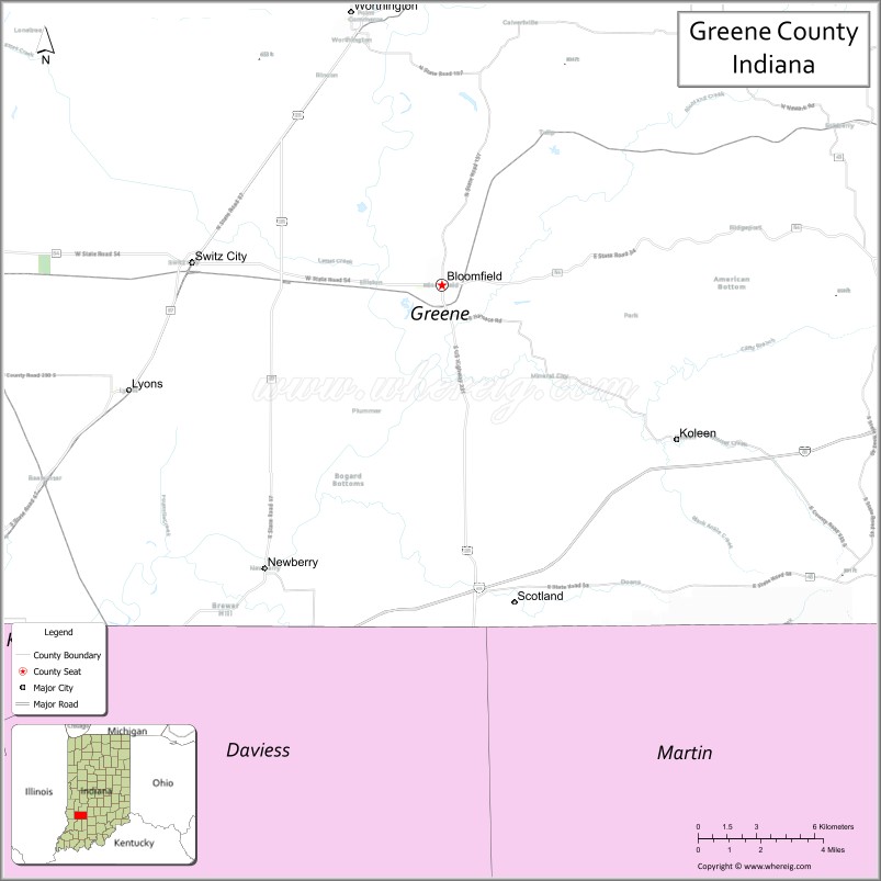
About Greene County Map, Alabama: The map showing the county boundary, county seat, major cities, highways, water bodies and neighbouring counties.
Related Indiana Maps
About Greene County, Indiana
Huntington County is a county located in the U.S. state of Indiana. It`s county seat is Huntington. As per 2020 census, the population of Huntington County was 36717 and population density of Huntington was square miles. According to the United States Census Bureau, the county has a total area of 383 sq mi (992 km2). Huntington County was established on -24803.
Greene County Facts
| Continent | North America |
| Country | United States |
| State | Indiana |
| County Seat | Bloomfield |
| Largest City/Town | Linton |
| Established | 1821 |
| Total Area | 545 sq mi |
| Land Area | 542 sq mi |
| Water Area | 2.8 sq mi |
| Population | 30,803 (Census 2020) |
| Population Density | 57 people per sq mi |
| Time Zone | Eastern Time Zone (ET) |
| Major Highways | US-231, IN-45, IN-54, IN-57, IN-59 |
| Neighboring Counties | Owen County (north), Monroe County (northeast), Brown County (east), Jackson County (southeast), Lawrence County (south), Martin County (southwest), Daviess County (west), Clay County (northwest) |
| Famous For | Coal mining history, rural landscapes, outdoor recreation |
| Top Attractions | Shakamak State Park, Goose Pond Fish & Wildlife Area, Sculpture Trails |
| Official Website | https://greenecounty.in.gov/ |
Cities and Towns in Greene County, Indiana
- Linton – 5,133 (Census 2020)
- Bloomfield (county seat) – 2,405 (Census 2020)
- Jasonville – 2,207 (Census 2020)
- Lyons – 724 (Census 2020)
- Worthington – 1,190 (Census 2020)
- Switz City – 293 (Census 2020)
Roads and Highways in Greene County, Indiana
Greene County is served by several highways that connect it to southwestern and central Indiana regions.
- US Route 231 – north-south highway connecting Bloomfield to Spencer and Jasper
- Indiana State Road 45 – runs east-west linking Bloomfield to Bloomington
- Indiana State Road 54 – east-west route connecting Linton to Sullivan and Bloomfield
- Indiana State Road 57 – connects Greene County to Worthington and Petersburg
- Indiana State Road 59 – north-south route linking Linton to Brazil and Jasonville
Neighboring Counties of Greene County
- Owen County (north)
- Monroe County (northeast)
- Brown County (east)
- Jackson County (southeast)
- Lawrence County (south)
- Martin County (southwest)
- Daviess County (west)
- Clay County (northwest)
Top Attractions in Greene County, Indiana
Greene County offers natural beauty, outdoor recreation, and historic sites across its rural landscape.
- Shakamak State Park – popular for lakes, camping, and hiking trails
- Goose Pond Fish & Wildlife Area – large wetland area ideal for birdwatching
- Sculpture Trails Outdoor Museum – unique art installations along wooded trails
- Plummer’s Orchard – seasonal fruit picking and family activities
- Linton Freedom Festival – annual event with fireworks and celebrations
- Bloomfield Courthouse Square – historic downtown area with shops
Distance from Greene County to Nearby Cities
- Greene County to Bloomington – 20 mi (32 km)
- Greene County to Terre Haute – 45 mi (72 km)
- Greene County to Indianapolis – 80 mi (129 km)
- Greene County to Evansville – 90 mi (145 km)
- Greene County to Louisville – 110 mi (177 km)
FAQs about Greene County
Greene County is located in southwestern Indiana.
The county seat is Bloomfield, while Linton is the largest city.
It is known for its coal mining history, parks, and outdoor recreation.
Yes, it is largely rural with small towns and natural landscapes.
The county is served by US-231 and several Indiana state roads including IN-45, IN-54, and IN-57.
- Adams County Map, IN
- Allen County Map, IN
- Bartholomew County Map, IN
- Benton County Map, IN
- Blackford County Map, IN
- Boone County Map, IN
- Brown County Map, IN
- Carroll County Map, IN
- Cass County Map, IN
- Clark County Map, IN
- Clay County Map, IN
- Clinton County Map, IN
- Crawford County Map, IN
- Daviess County Map, IN
- Dearborn County Map, IN
- Decatur County Map, IN
- DeKalb County Map, IN
- Delaware County Map, IN
- Dubois County Map, IN
- Elkhart County Map, IN
- Fayette County Map, IN
- Floyd County Map, IN
- Fountain County Map, IN
- Franklin County Map, IN
- Fulton County Map, IN
- Gibson County Map, IN
- Grant County Map, IN
- Greene County Map, IN
- Hamilton County Map, IN
- Hancock County Map, IN
- Harrison County Map, IN
- Hendricks County Map, IN
- Henry County Map, IN
- Howard County Map, IN
- Huntington County Map, IN
- Jackson County Map, IN
- Jasper County Map, IN
- Jay County Map, IN
- Jefferson County Map, IN
- Jennings County Map, IN
- Johnson County Map, IN
- Knox County Map, IN
- Kosciusko County Map, IN
- LaGrange County Map, IN
- Lake County Map, IN
- LaPorte County Map, IN
- Lawrence County Map, IN
- Madison County Map, IN
- Marion County Map, IN
- Marshall County Map, IN
- Martin County Map, IN
- Miami County Map, IN
- Monroe County Map, IN
- Montgomery County Map, IN
- Morgan County Map, IN
- Newton County Map, IN
- Noble County Map, IN
- Ohio County Map, IN
- Orange County Map, IN
- Owen County Map, IN
- Parke County Map, IN
- Perry County Map, IN
- Pike County Map, IN
- Porter County Map, IN
- Posey County Map, IN
- Pulaski County Map, IN
- Putnam County Map, IN
- Randolph County Map, IN
- Ripley County Map, IN
- Rush County Map, IN
- St Joseph County Map, IN
- Scott County Map, IN
- Shelby County Map, IN
- Spencer County Map, IN
- Starke County Map, IN
- Steuben County Map, IN
- Sullivan County Map, IN
- Switzerland County Map, IN
- Tippecanoe County Map, IN
- Tipton County Map, IN
- Union County Map, IN
- Vanderburgh County Map, IN
- Vermillion County Map, IN
- Vigo County Map, IN
- Wabash County Map, IN
- Warren County Map, IN
- Warrick County Map, IN
- Washington County Map, IN
- Wayne County Map, IN
- Wells County Map, IN
- White County Map, IN
- Whitley County Map, IN
- Alabama Counties
- Alaska boroughs
- Arizona Counties
- Arkansas Counties
- California County Map
- Colorado Counties
- Connecticut Counties
- Delaware Counties
- Florida County Map
- Georgia County Map
- Hawaii Counties
- Idaho Counties
- Illinois Counties
- Indiana Counties
- Iowa Counties
- Kansas Counties
- Kentucky Counties
- Louisiana Counties
- Maine Counties
- Maryland Counties
- Massachusetts Counties
- Michigan County Map
- Minnesota Counties
- Mississippi Counties
- Missouri Counties
- Montana Counties
- Nebraska Counties
- Nevada Counties
- New York Counties
- New Hampshire Counties
- New Jersey Counties
- New Mexico Counties
- North Carolina Counties
- North Dakota Counties
- Ohio County Map
- Oklahoma Counties
- Oregon Counties
- Pennsylvania Counties
- Rhode Island Counties
- South Carolina Counties
- South Dakota Counties
- Map of Tennessee
- Texas County Map
- Utah Counties
- Vermont Counties
- Virginia Counties
- Washington Counties
- West Virginia Counties
- Wisconsin Counties
- Wyoming Counties