By Whereig Editors, Reviewed by Mukesh Kumar| Updated On: May 02, 2026 | 20:16 ET
Map of Johnson County - Johnson County is a county located in the U.S. state of Indiana. Johnson County Map showing cities, highways, important places and water bodies. Get Where is Johnson County located in the map, major cities in Johnson county, population, areas, and places of interest.
Map of Johnson County, Indiana
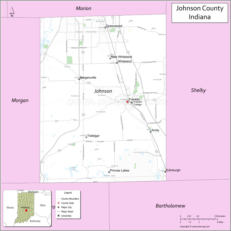
About Johnson County Map, Alabama: The map showing the county boundary, county seat, major cities, highways, water bodies and neighbouring counties.
Related Indiana Maps
About Johnson County, Indiana
Madison County is a county located in the U.S. state of Indiana. It`s county seat is Anderson. As per 2020 census, the population of Madison County was 130782 and population density of Madison was square miles. According to the United States Census Bureau, the county has a total area of 452 sq mi (1,171 km2). Madison County was established on -28119.
Johnson County Facts
| Continent | North America |
| Country | United States |
| State | Indiana |
| County Seat | Franklin |
| Largest City/Town | Greenwood |
| Established | 1823 |
| Total Area | 322 sq mi |
| Land Area | 320 sq mi |
| Water Area | 1.9 sq mi |
| Population | 161,765 (Census 2020) |
| Population Density | 505 people per sq mi |
| Time Zone | Eastern Time Zone (ET) |
| Major Highways | I-65, US-31, IN-44, IN-135 |
| Neighboring Counties | Marion County (north), Shelby County (east), Bartholomew County (south), Brown County (southwest), Morgan County (west) |
| Famous For | Greenwood, suburban growth, proximity to Indianapolis |
| Top Attractions | Greenwood Park Mall, Johnson County Park, Historic Franklin |
| Official Website | https://johnsoncounty.in.gov/ |
Cities and Towns in Johnson County, Indiana
- Greenwood – 63,830 (Census 2020)
- Franklin (county seat) – 25,996 (Census 2020)
- Whiteland – 4,413 (Census 2020)
- Bargersville – 10,373 (Census 2020)
- Trafalgar – 1,101 (Census 2020)
- Princes Lakes (partly) – 2,724 (Census 2020)
- New Whiteland – 6,694 (Census 2020)
Roads and Highways in Johnson County, Indiana
Johnson County is well connected by major highways that provide quick access to Indianapolis and southern Indiana.
- Interstate 65 (I-65) – north-south route connecting Greenwood and Franklin to Indianapolis and Louisville
- US Route 31 – runs parallel to I-65 linking Greenwood to Franklin and Columbus
- Indiana State Road 44 – east-west route connecting Franklin to Shelbyville and Martinsville
- Indiana State Road 135 – connects Greenwood to Nashville and Brown County
Neighboring Counties of Johnson County
- Marion County (north)
- Shelby County (east)
- Bartholomew County (south)
- Brown County (southwest)
- Morgan County (west)
Top Attractions in Johnson County, Indiana
Johnson County offers a mix of suburban amenities, parks, and historic areas.
- Greenwood Park Mall – major shopping destination in the county
- Johnson County Park – large park with trails, lakes, and recreation
- Historic Franklin – charming downtown with shops and restaurants
- Craig Park – popular park in Greenwood with sports and playgrounds
- Hocker Grove Park – community park with trails and picnic areas
- Bargersville Downtown – growing area with local dining and shops
Distance from Johnson County to Nearby Cities
- Johnson County to Indianapolis – 15 mi (24 km)
- Johnson County to Bloomington – 50 mi (80 km)
- Johnson County to Columbus – 25 mi (40 km)
- Johnson County to Louisville – 100 mi (161 km)
- Johnson County to Cincinnati – 110 mi (177 km)
FAQs about Johnson County
Johnson County is located in central Indiana just south of Indianapolis.
The county seat is Franklin, while Greenwood is the largest city.
It is known for suburban growth, Greenwood, and its proximity to Indianapolis.
Yes, it is part of the Indianapolis metropolitan area.
The county is served by I-65, US-31, and several Indiana state roads.
- Adams County Map, IN
- Allen County Map, IN
- Bartholomew County Map, IN
- Benton County Map, IN
- Blackford County Map, IN
- Boone County Map, IN
- Brown County Map, IN
- Carroll County Map, IN
- Cass County Map, IN
- Clark County Map, IN
- Clay County Map, IN
- Clinton County Map, IN
- Crawford County Map, IN
- Daviess County Map, IN
- Dearborn County Map, IN
- Decatur County Map, IN
- DeKalb County Map, IN
- Delaware County Map, IN
- Dubois County Map, IN
- Elkhart County Map, IN
- Fayette County Map, IN
- Floyd County Map, IN
- Fountain County Map, IN
- Franklin County Map, IN
- Fulton County Map, IN
- Gibson County Map, IN
- Grant County Map, IN
- Greene County Map, IN
- Hamilton County Map, IN
- Hancock County Map, IN
- Harrison County Map, IN
- Hendricks County Map, IN
- Henry County Map, IN
- Howard County Map, IN
- Huntington County Map, IN
- Jackson County Map, IN
- Jasper County Map, IN
- Jay County Map, IN
- Jefferson County Map, IN
- Jennings County Map, IN
- Johnson County Map, IN
- Knox County Map, IN
- Kosciusko County Map, IN
- LaGrange County Map, IN
- Lake County Map, IN
- LaPorte County Map, IN
- Lawrence County Map, IN
- Madison County Map, IN
- Marion County Map, IN
- Marshall County Map, IN
- Martin County Map, IN
- Miami County Map, IN
- Monroe County Map, IN
- Montgomery County Map, IN
- Morgan County Map, IN
- Newton County Map, IN
- Noble County Map, IN
- Ohio County Map, IN
- Orange County Map, IN
- Owen County Map, IN
- Parke County Map, IN
- Perry County Map, IN
- Pike County Map, IN
- Porter County Map, IN
- Posey County Map, IN
- Pulaski County Map, IN
- Putnam County Map, IN
- Randolph County Map, IN
- Ripley County Map, IN
- Rush County Map, IN
- St Joseph County Map, IN
- Scott County Map, IN
- Shelby County Map, IN
- Spencer County Map, IN
- Starke County Map, IN
- Steuben County Map, IN
- Sullivan County Map, IN
- Switzerland County Map, IN
- Tippecanoe County Map, IN
- Tipton County Map, IN
- Union County Map, IN
- Vanderburgh County Map, IN
- Vermillion County Map, IN
- Vigo County Map, IN
- Wabash County Map, IN
- Warren County Map, IN
- Warrick County Map, IN
- Washington County Map, IN
- Wayne County Map, IN
- Wells County Map, IN
- White County Map, IN
- Whitley County Map, IN
- Alabama Counties
- Alaska boroughs
- Arizona Counties
- Arkansas Counties
- California County Map
- Colorado Counties
- Connecticut Counties
- Delaware Counties
- Florida County Map
- Georgia County Map
- Hawaii Counties
- Idaho Counties
- Illinois Counties
- Indiana Counties
- Iowa Counties
- Kansas Counties
- Kentucky Counties
- Louisiana Counties
- Maine Counties
- Maryland Counties
- Massachusetts Counties
- Michigan County Map
- Minnesota Counties
- Mississippi Counties
- Missouri Counties
- Montana Counties
- Nebraska Counties
- Nevada Counties
- New York Counties
- New Hampshire Counties
- New Jersey Counties
- New Mexico Counties
- North Carolina Counties
- North Dakota Counties
- Ohio County Map
- Oklahoma Counties
- Oregon Counties
- Pennsylvania Counties
- Rhode Island Counties
- South Carolina Counties
- South Dakota Counties
- Map of Tennessee
- Texas County Map
- Utah Counties
- Vermont Counties
- Virginia Counties
- Washington Counties
- West Virginia Counties
- Wisconsin Counties
- Wyoming Counties