Map of Charles City County - Charles City County is a county located in the U.S. state of Virginia. Charles City County Map showing cities, highways, important places and water bodies. Get Where is Charles City County located in the map, major cities in Charles City county, population, areas, and places of interest.
Map of Charles City County, Virginia
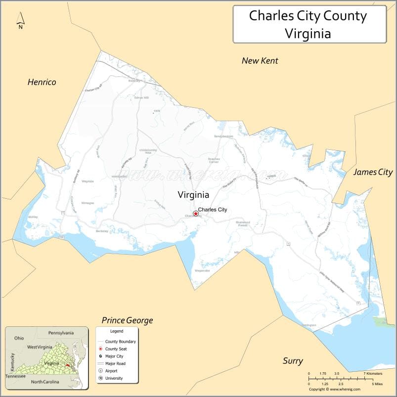
About Charles City County Map, Alabama: The map showing the county boundary, county seat, major cities, highways, water bodies and neighbouring counties.
Related Virginia Links
| Virginia Map | Counties in Virginia | Cities in Virginia |
| Airports in Virginia | Zip Codes in Virginia | Where is Virginia |
| Where is Richmond | Where is Chesapeake | Where is Virginia Beach |
Map of Charles City County, Virginia
Norfolk County is a county located in the U.S. state of Virginia. It`s county seat is N/A. As per 2020 census, the population of Norfolk County was 235089 and population density of Norfolk was square miles. According to the United States Census Bureau, the county has a total area of 54 sq mi (140 km2). Norfolk County was established on 1845[15].
Charles City County Facts
| Continent | North America |
| Country | United States |
| State | Virginia |
| County Seat | Charles City |
| Largest City/Town | N/A (no incorporated cities) |
| Established | 1634 |
| Total Area | 204 sq mi (528 sq km) |
| Land Area | 183 sq mi (474 sq km) |
| Water Area | 21 sq mi (54 sq km) |
| Population | 6,773 (Census 2020) |
| Population Density | 37 people per sq mi |
| Time Zone | Eastern (EST) |
| Major Highways | VA-5, VA-156 |
| Major Rivers | James River, Chickahominy River |
| Neighboring Counties | Henrico County, New Kent County, Prince George County, Surry County |
| Famous For | Historic plantations, colonial history, scenic byways |
| Top Attractions | Berkeley Plantation, Shirley Plantation, Scenic Route 5 |
| Official Website | Official Website |
About Charles City County, Virginia
Charles City County is located in the eastern part of Virginia along the James River in the state of the United States, and was established in 1634 as one of the original shires of Virginia. The county seat is the unincorporated community of Charles City. The county is known for its rich colonial history, well-preserved plantations, and scenic landscapes along the river.
Cities and Towns in Charles City County, Virginia
| City/Town | Population (Census 2020) | Latitude & Longitude |
|---|---|---|
| Charles City (county seat, CDP) | 120 | 37.3560°N, 77.0708°W |
| Ruthville (CDP) | 200 | 37.3800°N, 77.2000°W |
| Roxbury (CDP) | 150 | 37.2800°N, 77.1500°W |
| Weinstein (CDP) | 100 | 37.3400°N, 77.1100°W |
| Sandy Point (CDP) | 100 | 37.3000°N, 77.0500°W |
| Wayside (CDP) | 150 | 37.3200°N, 77.1800°W |
Golf Courses in Charles City County, Virginia
| Golf Course | Location | Latitude & Longitude |
|---|---|---|
| Royal New Kent Golf Club | Near county border (New Kent area) | 37.4305°N, 76.9890°W |
| Kiskiack Golf Club (nearby) | Williamsburg area | 37.3430°N, 76.7800°W |
Roads and Highways in Charles City County, Virginia
The county is connected by scenic and regional roadways.
- VA-5 – historic scenic route along the James River connecting Richmond and Williamsburg
- VA-156 – connects Charles City County to surrounding counties
Neighboring Counties of Charles City County
- Henrico County (northwest)
- New Kent County (northeast)
- Prince George County (south)
- Surry County (south across the James River)
Top Attractions in Charles City County, Virginia
The county is rich in history and scenic beauty.
- Berkeley Plantation – historic home of Benjamin Harrison and birthplace of William Henry Harrison
- Shirley Plantation – one of the oldest active plantations in the United States
- Westover Plantation – historic estate along the James River
- Scenic Route 5 – picturesque drive connecting historic plantations
- Chickahominy Wildlife Management Area – outdoor recreation and wildlife viewing
- James River – boating, fishing, and scenic views
Distance from Charles City County to Nearby Cities
- Charles City to Richmond, VA – 25 mi (40 km)
- Charles City to Williamsburg, VA – 35 mi (56 km)
- Charles City to Newport News, VA – 50 mi (80 km)
- Charles City to Norfolk, VA – 90 mi (145 km)
- Charles City to Washington, DC – 110 mi (177 km)
FAQs about Charles City County
Charles City County is located in eastern Virginia along the James River between Richmond and Williamsburg.
The population of Charles City County is 6,773 according to the 2020 Census.
The county is known for its historic plantations, colonial heritage, and scenic river views.
The main highways include Virginia Route 5 and Virginia Route 156.
There are no major golf courses directly in the county, but nearby areas offer several options.
- Accomack County Map, VA
- Albemarle County Map, VA
- Alleghany County Map, VA
- Amelia County Map, VA
- Amherst County Map, VA
- Appomattox County Map, VA
- Arlington County Map, VA
- Augusta County Map, VA
- Bath County Map, VA
- Bedford County Map, VA
- Bland County Map, VA
- Botetourt County Map, VA
- Brunswick County Map, VA
- Buchanan County Map, VA
- Buckingham County Map, VA
- Campbell County Map, VA
- Caroline County Map, VA
- Carroll County Map, VA
- Charles City County Map, VA
- Charlotte County Map, VA
- Chesterfield County Map, VA
- Clarke County Map, VA
- Craig County Map, VA
- Culpeper County Map, VA
- Cumberland County Map, VA
- Dickenson County Map, VA
- Dinwiddie County Map, VA
- Essex County Map, VA
- Fairfax County Map, VA
- Fauquier County Map, VA
- Floyd County Map, VA
- Fluvanna County Map, VA
- Franklin County Map, VA
- Frederick County Map, VA
- Giles County Map, VA
- Gloucester County Map, VA
- Goochland County Map, VA
- Grayson County Map, VA
- Greene County Map, VA
- Greensville County Map, VA
- Halifax County Map, VA
- Hanover County Map, VA
- Henrico County Map, VA
- Henry County Map, VA
- Highland County Map, VA
- Isle of Wight County Map, VA
- James City County Map, VA
- King and Queen County Map, VA
- King George County Map, VA
- King William County Map, VA
- Lancaster County Map, VA
- Lee County Map, VA
- Loudoun County Map, VA
- Louisa County Map, VA
- Lunenburg County Map, VA
- Madison County Map, VA
- Mathews County Map, VA
- Mecklenburg County Map, VA
- Middlesex County Map, VA
- Montgomery County Map, VA
- Nelson County Map, VA
- New Kent County Map, VA
- Northampton County Map, VA
- Northumberland County Map, VA
- Nottoway County Map, VA
- Orange County Map, VA
- Page County Map, VA
- Patrick County Map, VA
- Pittsylvania County Map, VA
- Powhatan County Map, VA
- Prince Edward County Map, VA
- Prince George County Map, VA
- Prince William County Map, VA
- Pulaski County Map, VA
- Rappahannock County Map, VA
- Richmond County Map, VA
- Roanoke County Map, VA
- Rockbridge County Map, VA
- Rockingham County Map, VA
- Russell County Map, VA
- Scott County Map, VA
- Shenandoah County Map, VA
- Smyth County Map, VA
- Southampton County Map, VA
- Spotsylvania County Map, VA
- Stafford County Map, VA
- Surry County Map, VA
- Sussex County Map, VA
- Tazewell County Map, VA
- Warren County Map, VA
- Washington County Map, VA
- Westmoreland County Map, VA
- Wise County Map, VA
- Wythe County Map, VA
- York County Map, VA
- Alexandria County Map, VA
- Bristol County Map, VA
- Buena Vista County Map, VA
- Charlottesville County Map, VA
- Chesapeake County Map, VA
- Colonial Heights County Map, VA
- Covington County Map, VA
- Danville County Map, VA
- Emporia County Map, VA
- Fairfax County Map, VA
- Falls Church County Map, VA
- Alabama Counties
- Alaska boroughs
- Arizona Counties
- Arkansas Counties
- California County Map
- Colorado Counties
- Connecticut Counties
- Delaware Counties
- Florida County Map
- Georgia County Map
- Hawaii Counties
- Idaho Counties
- Illinois Counties
- Indiana Counties
- Iowa Counties
- Kansas Counties
- Kentucky Counties
- Louisiana Counties
- Maine Counties
- Maryland Counties
- Massachusetts Counties
- Michigan County Map
- Minnesota Counties
- Mississippi Counties
- Missouri Counties
- Montana Counties
- Nebraska Counties
- Nevada Counties
- New York Counties
- New Hampshire Counties
- New Jersey Counties
- New Mexico Counties
- North Carolina Counties
- North Dakota Counties
- Ohio County Map
- Oklahoma Counties
- Oregon Counties
- Pennsylvania Counties
- Rhode Island Counties
- South Carolina Counties
- South Dakota Counties
- Map of Tennessee
- Texas County Map
- Utah Counties
- Vermont Counties
- Virginia Counties
- Washington Counties
- West Virginia Counties
- Wisconsin Counties
- Wyoming Counties