Map of James City County - James City County is a county located in the U.S. state of Virginia. James City County Map showing cities, highways, important places and water bodies. Get Where is James City County located in the map, major cities in James City county, population, areas, and places of interest.
Map of James City County, Virginia
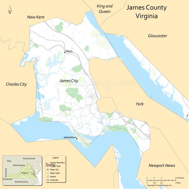
About James City County Map, Alabama: The map showing the county boundary, county seat, major cities, highways, water bodies and neighbouring counties.
Related Virginia Links
| Virginia Map | Counties in Virginia | Cities in Virginia |
| Airports in Virginia | Zip Codes in Virginia | Where is Virginia |
| Where is Richmond | Where is Chesapeake | Where is Virginia Beach |
Map of James City County, Virginia
King County is a county located in the U.S. state of Washington. It`s county seat is Seattle. As per 2020 census, the population of King County was 2269675 and population density of King was square miles. According to the United States Census Bureau, the county has a total area of 2,115 sq mi (5,478 km2). King County was established on 1852.
James City County Facts
| Continent | North America |
| Country | United States |
| State | Virginia |
| County Seat | Williamsburg (independent city) |
| Largest City/Town | Williamsburg area (CDP) |
| Established | 1634 |
| Total Area | 179 sq mi (464 sq km) |
| Land Area | 143 sq mi (370 sq km) |
| Water Area | 36 sq mi (93 sq km) |
| Population | 77,008 (Census 2020) |
| Population Density | 538 people per sq mi |
| Time Zone | Eastern (EST) |
| Major Highways | I-64, US-60, VA-199 |
| Major Rivers | James River, Chickahominy River |
| Neighboring Counties | York County, New Kent County, Charles City County, Surry County |
| Famous For | Colonial history, Jamestown, tourism |
| Top Attractions | Jamestown Settlement, Colonial Williamsburg, Busch Gardens |
| Official Website | Official Website |
About James City County, Virginia
James City County is located in the southeastern part of Virginia in the state of the United States, and was established in 1634 as one of the original shires of colonial Virginia. The county seat is Williamsburg, an independent city that serves as the administrative center. The county lies between the James and Chickahominy rivers and is known for its historical significance, being home to Jamestown, the first permanent English settlement in America.
Cities and Towns in James City County, Virginia
| City/Town | Population (Census 2020) | Latitude & Longitude |
|---|---|---|
| Williamsburg (independent city, county seat) | 15,425 | 37.2707°N, 76.7075°W |
| Toano (CDP) | 3,200 | 37.3750°N, 76.8000°W |
| Lightfoot (CDP) | 3,500 | 37.3100°N, 76.7200°W |
| Grove (CDP) | 2,000 | 37.2100°N, 76.7700°W |
| Lanexa (CDP) | 1,200 | 37.4000°N, 76.9000°W |
| Kingsmill (CDP) | 7,000 | 37.2300°N, 76.6900°W |
Golf Courses in James City County, Virginia
| Golf Course | Location | Latitude & Longitude |
|---|---|---|
| Kingsmill Resort Golf Courses | Kingsmill | 37.2300°N, 76.6900°W |
| Ford’s Colony Country Club | Williamsburg area | 37.3100°N, 76.7600°W |
Roads and Highways in James City County, Virginia
The county is well connected within the Hampton Roads region.
- I-64 – major interstate connecting Richmond and Hampton Roads
- US-60 – historic route through Williamsburg
- VA-199 – local connector road around Williamsburg
Neighboring Counties of James City County
- New Kent County (north)
- Charles City County (northwest)
- Surry County (south, across James River)
- York County (east)
Top Attractions in James City County, Virginia
The county is one of Virginia’s top tourist destinations.
- Jamestown Settlement – historic museum and living history site
- Colonial Williamsburg – restored 18th-century town
- Busch Gardens Williamsburg – theme park and entertainment
- Historic Jamestowne – archaeological site of original settlement
- Chickahominy Riverfront Park – camping and boating
- Kingsmill Resort – golf and luxury accommodations
Distance from James City County to Nearby Cities
- Williamsburg to Richmond, VA – 55 mi (89 km)
- Williamsburg to Norfolk, VA – 45 mi (72 km)
- Williamsburg to Virginia Beach, VA – 60 mi (97 km)
- Williamsburg to Newport News, VA – 20 mi (32 km)
- Williamsburg to Washington, DC – 150 mi (241 km)
FAQs about James City County
James City County is located in southeastern Virginia between the James and Chickahominy rivers.
The population of James City County is 77,008 according to the 2020 Census.
The county is known for Jamestown, Colonial Williamsburg, and its historical significance.
The main highways include Interstate 64, US-60, and Virginia Route 199.
Yes, James City County has golf courses such as Kingsmill Resort and Ford’s Colony Country Club.
- Accomack County Map, VA
- Albemarle County Map, VA
- Alleghany County Map, VA
- Amelia County Map, VA
- Amherst County Map, VA
- Appomattox County Map, VA
- Arlington County Map, VA
- Augusta County Map, VA
- Bath County Map, VA
- Bedford County Map, VA
- Bland County Map, VA
- Botetourt County Map, VA
- Brunswick County Map, VA
- Buchanan County Map, VA
- Buckingham County Map, VA
- Campbell County Map, VA
- Caroline County Map, VA
- Carroll County Map, VA
- Charles City County Map, VA
- Charlotte County Map, VA
- Chesterfield County Map, VA
- Clarke County Map, VA
- Craig County Map, VA
- Culpeper County Map, VA
- Cumberland County Map, VA
- Dickenson County Map, VA
- Dinwiddie County Map, VA
- Essex County Map, VA
- Fairfax County Map, VA
- Fauquier County Map, VA
- Floyd County Map, VA
- Fluvanna County Map, VA
- Franklin County Map, VA
- Frederick County Map, VA
- Giles County Map, VA
- Gloucester County Map, VA
- Goochland County Map, VA
- Grayson County Map, VA
- Greene County Map, VA
- Greensville County Map, VA
- Halifax County Map, VA
- Hanover County Map, VA
- Henrico County Map, VA
- Henry County Map, VA
- Highland County Map, VA
- Isle of Wight County Map, VA
- James City County Map, VA
- King and Queen County Map, VA
- King George County Map, VA
- King William County Map, VA
- Lancaster County Map, VA
- Lee County Map, VA
- Loudoun County Map, VA
- Louisa County Map, VA
- Lunenburg County Map, VA
- Madison County Map, VA
- Mathews County Map, VA
- Mecklenburg County Map, VA
- Middlesex County Map, VA
- Montgomery County Map, VA
- Nelson County Map, VA
- New Kent County Map, VA
- Northampton County Map, VA
- Northumberland County Map, VA
- Nottoway County Map, VA
- Orange County Map, VA
- Page County Map, VA
- Patrick County Map, VA
- Pittsylvania County Map, VA
- Powhatan County Map, VA
- Prince Edward County Map, VA
- Prince George County Map, VA
- Prince William County Map, VA
- Pulaski County Map, VA
- Rappahannock County Map, VA
- Richmond County Map, VA
- Roanoke County Map, VA
- Rockbridge County Map, VA
- Rockingham County Map, VA
- Russell County Map, VA
- Scott County Map, VA
- Shenandoah County Map, VA
- Smyth County Map, VA
- Southampton County Map, VA
- Spotsylvania County Map, VA
- Stafford County Map, VA
- Surry County Map, VA
- Sussex County Map, VA
- Tazewell County Map, VA
- Warren County Map, VA
- Washington County Map, VA
- Westmoreland County Map, VA
- Wise County Map, VA
- Wythe County Map, VA
- York County Map, VA
- Alexandria County Map, VA
- Bristol County Map, VA
- Buena Vista County Map, VA
- Charlottesville County Map, VA
- Chesapeake County Map, VA
- Colonial Heights County Map, VA
- Covington County Map, VA
- Danville County Map, VA
- Emporia County Map, VA
- Fairfax County Map, VA
- Falls Church County Map, VA
- Alabama Counties
- Alaska boroughs
- Arizona Counties
- Arkansas Counties
- California County Map
- Colorado Counties
- Connecticut Counties
- Delaware Counties
- Florida County Map
- Georgia County Map
- Hawaii Counties
- Idaho Counties
- Illinois Counties
- Indiana Counties
- Iowa Counties
- Kansas Counties
- Kentucky Counties
- Louisiana Counties
- Maine Counties
- Maryland Counties
- Massachusetts Counties
- Michigan County Map
- Minnesota Counties
- Mississippi Counties
- Missouri Counties
- Montana Counties
- Nebraska Counties
- Nevada Counties
- New York Counties
- New Hampshire Counties
- New Jersey Counties
- New Mexico Counties
- North Carolina Counties
- North Dakota Counties
- Ohio County Map
- Oklahoma Counties
- Oregon Counties
- Pennsylvania Counties
- Rhode Island Counties
- South Carolina Counties
- South Dakota Counties
- Map of Tennessee
- Texas County Map
- Utah Counties
- Vermont Counties
- Virginia Counties
- Washington Counties
- West Virginia Counties
- Wisconsin Counties
- Wyoming Counties