Map of Prince Edward County - Prince Edward County is a county located in the U.S. state of Virginia. Prince Edward County Map showing cities, highways, important places and water bodies. Get Where is Prince Edward County located in the map, major cities in Prince Edward county, population, areas, and places of interest.
Map of Prince Edward County, Virginia
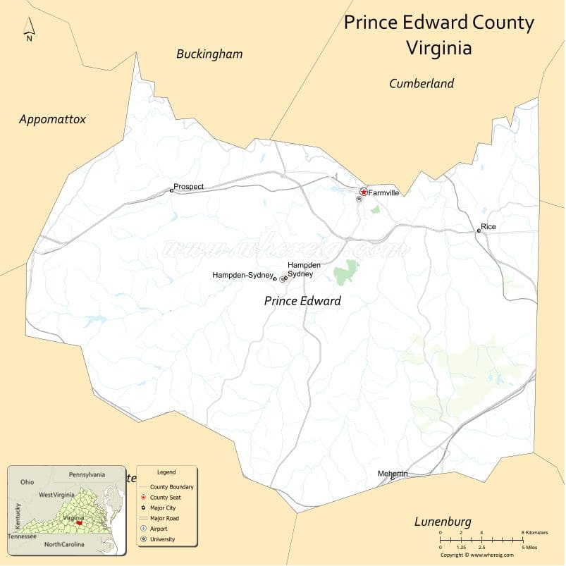
About Prince Edward County Map, Alabama: The map showing the county boundary, county seat, major cities, highways, water bodies and neighbouring counties.
Related Virginia Links
| Virginia Map | Counties in Virginia | Cities in Virginia |
| Airports in Virginia | Zip Codes in Virginia | Where is Virginia |
| Where is Richmond | Where is Chesapeake | Where is Virginia Beach |
Map of Prince Edward County, Virginia
Berkeley County is a county located in the U.S. state of West Virginia. It`s county seat is Martinsburg. As per 2020 census, the population of Berkeley County was 126069 and population density of Berkeley was square miles. According to the United States Census Bureau, the county has a total area of 321 sq mi (831 km2). Berkeley County was established on 1772.
Prince Edward County Facts
| Continent | North America |
| Country | United States |
| State | Virginia |
| County Seat | Farmville |
| Largest City/Town | Farmville |
| Established | 1754 |
| Total Area | 354 sq mi (917 sq km) |
| Land Area | 350 sq mi (907 sq km) |
| Water Area | 4 sq mi (10 sq km) |
| Population | 23,050 (Census 2020) |
| Population Density | 66 people per sq mi |
| Time Zone | Eastern (EST) |
| Major Highways | US-460, US-15, VA-45 |
| Major Rivers | Appomattox River |
| Neighboring Counties | Cumberland County, Buckingham County, Charlotte County, Lunenburg County, Nottoway County, Amelia County |
| Famous For | Longwood University, Civil Rights history, rural landscapes |
| Top Attractions | High Bridge Trail State Park, Longwood University, Robert Russa Moton Museum |
| Official Website | Official Website |
About Prince Edward County, Virginia
Prince Edward County is located in the central part of Virginia in the state of the United States, and was established in 1754. The county seat is Farmville, which is also the largest town. The county lies along the Appomattox River and is known for its educational institutions, historic significance in the Civil Rights Movement, and scenic rural environment.
Cities and Towns in Prince Edward County, Virginia
| City/Town | Population (Census 2020) | Latitude & Longitude |
|---|---|---|
| Farmville (county seat, town) | 7,500 | 37.3000°N, 78.3900°W |
| Pamplin City (town) | 200 | 37.2600°N, 78.6800°W |
| Hampden Sydney (CDP) | 1,400 | 37.2400°N, 78.4600°W |
| Prospect (CDP) | 700 | 37.3000°N, 78.5600°W |
| Rice (CDP) | 500 | 37.2500°N, 78.2900°W |
| Meherrin (CDP) | 300 | 37.1000°N, 78.3800°W |
Golf Courses in Prince Edward County, Virginia
| Golf Course | Location | Latitude & Longitude |
|---|---|---|
| The Manor Golf Club | Farmville | 37.3000°N, 78.3900°W |
| Longwood Golf Course | Farmville | 37.3000°N, 78.3900°W |
Roads and Highways in Prince Edward County, Virginia
The county is connected by major highways through central Virginia.
- US-460 – primary east-west route
- US-15 – north-south highway
- VA-45 – regional connector
Neighboring Counties of Prince Edward County
- Cumberland County (north)
- Buckingham County (northwest)
- Charlotte County (southwest)
- Lunenburg County (south)
- Nottoway County (east)
- Amelia County (northeast)
Top Attractions in Prince Edward County, Virginia
The county offers history, education, and outdoor recreation.
- High Bridge Trail State Park – long recreational trail
- Longwood University – historic campus
- Robert Russa Moton Museum – Civil Rights history
- Appomattox River – fishing and kayaking
- Downtown Farmville – shops and dining
Distance from Prince Edward County to Nearby Cities
- Farmville to Richmond, VA – 65 mi (105 km)
- Farmville to Lynchburg, VA – 50 mi (80 km)
- Farmville to Charlottesville, VA – 60 mi (97 km)
- Farmville to Roanoke, VA – 120 mi (193 km)
- Farmville to Washington, DC – 160 mi (257 km)
FAQs about Prince Edward County
Prince Edward County is located in central Virginia along the Appomattox River.
The population of Prince Edward County is 23,050 according to the 2020 Census.
The county is known for Longwood University and its role in Civil Rights history.
The main highways include US-460, US-15, and Virginia Route 45.
Yes, Prince Edward County has golf courses such as The Manor Golf Club and Longwood Golf Course.
- Accomack County Map, VA
- Albemarle County Map, VA
- Alleghany County Map, VA
- Amelia County Map, VA
- Amherst County Map, VA
- Appomattox County Map, VA
- Arlington County Map, VA
- Augusta County Map, VA
- Bath County Map, VA
- Bedford County Map, VA
- Bland County Map, VA
- Botetourt County Map, VA
- Brunswick County Map, VA
- Buchanan County Map, VA
- Buckingham County Map, VA
- Campbell County Map, VA
- Caroline County Map, VA
- Carroll County Map, VA
- Charles City County Map, VA
- Charlotte County Map, VA
- Chesterfield County Map, VA
- Clarke County Map, VA
- Craig County Map, VA
- Culpeper County Map, VA
- Cumberland County Map, VA
- Dickenson County Map, VA
- Dinwiddie County Map, VA
- Essex County Map, VA
- Fairfax County Map, VA
- Fauquier County Map, VA
- Floyd County Map, VA
- Fluvanna County Map, VA
- Franklin County Map, VA
- Frederick County Map, VA
- Giles County Map, VA
- Gloucester County Map, VA
- Goochland County Map, VA
- Grayson County Map, VA
- Greene County Map, VA
- Greensville County Map, VA
- Halifax County Map, VA
- Hanover County Map, VA
- Henrico County Map, VA
- Henry County Map, VA
- Highland County Map, VA
- Isle of Wight County Map, VA
- James City County Map, VA
- King and Queen County Map, VA
- King George County Map, VA
- King William County Map, VA
- Lancaster County Map, VA
- Lee County Map, VA
- Loudoun County Map, VA
- Louisa County Map, VA
- Lunenburg County Map, VA
- Madison County Map, VA
- Mathews County Map, VA
- Mecklenburg County Map, VA
- Middlesex County Map, VA
- Montgomery County Map, VA
- Nelson County Map, VA
- New Kent County Map, VA
- Northampton County Map, VA
- Northumberland County Map, VA
- Nottoway County Map, VA
- Orange County Map, VA
- Page County Map, VA
- Patrick County Map, VA
- Pittsylvania County Map, VA
- Powhatan County Map, VA
- Prince Edward County Map, VA
- Prince George County Map, VA
- Prince William County Map, VA
- Pulaski County Map, VA
- Rappahannock County Map, VA
- Richmond County Map, VA
- Roanoke County Map, VA
- Rockbridge County Map, VA
- Rockingham County Map, VA
- Russell County Map, VA
- Scott County Map, VA
- Shenandoah County Map, VA
- Smyth County Map, VA
- Southampton County Map, VA
- Spotsylvania County Map, VA
- Stafford County Map, VA
- Surry County Map, VA
- Sussex County Map, VA
- Tazewell County Map, VA
- Warren County Map, VA
- Washington County Map, VA
- Westmoreland County Map, VA
- Wise County Map, VA
- Wythe County Map, VA
- York County Map, VA
- Alexandria County Map, VA
- Bristol County Map, VA
- Buena Vista County Map, VA
- Charlottesville County Map, VA
- Chesapeake County Map, VA
- Colonial Heights County Map, VA
- Covington County Map, VA
- Danville County Map, VA
- Emporia County Map, VA
- Fairfax County Map, VA
- Falls Church County Map, VA
- Alabama Counties
- Alaska boroughs
- Arizona Counties
- Arkansas Counties
- California County Map
- Colorado Counties
- Connecticut Counties
- Delaware Counties
- Florida County Map
- Georgia County Map
- Hawaii Counties
- Idaho Counties
- Illinois Counties
- Indiana Counties
- Iowa Counties
- Kansas Counties
- Kentucky Counties
- Louisiana Counties
- Maine Counties
- Maryland Counties
- Massachusetts Counties
- Michigan County Map
- Minnesota Counties
- Mississippi Counties
- Missouri Counties
- Montana Counties
- Nebraska Counties
- Nevada Counties
- New York Counties
- New Hampshire Counties
- New Jersey Counties
- New Mexico Counties
- North Carolina Counties
- North Dakota Counties
- Ohio County Map
- Oklahoma Counties
- Oregon Counties
- Pennsylvania Counties
- Rhode Island Counties
- South Carolina Counties
- South Dakota Counties
- Map of Tennessee
- Texas County Map
- Utah Counties
- Vermont Counties
- Virginia Counties
- Washington Counties
- West Virginia Counties
- Wisconsin Counties
- Wyoming Counties