Map of Prince George County - Prince George County is a county located in the U.S. state of Virginia. Prince George County Map showing cities, highways, important places and water bodies. Get Where is Prince George County located in the map, major cities in Prince George county, population, areas, and places of interest.
Map of Prince George County, Virginia
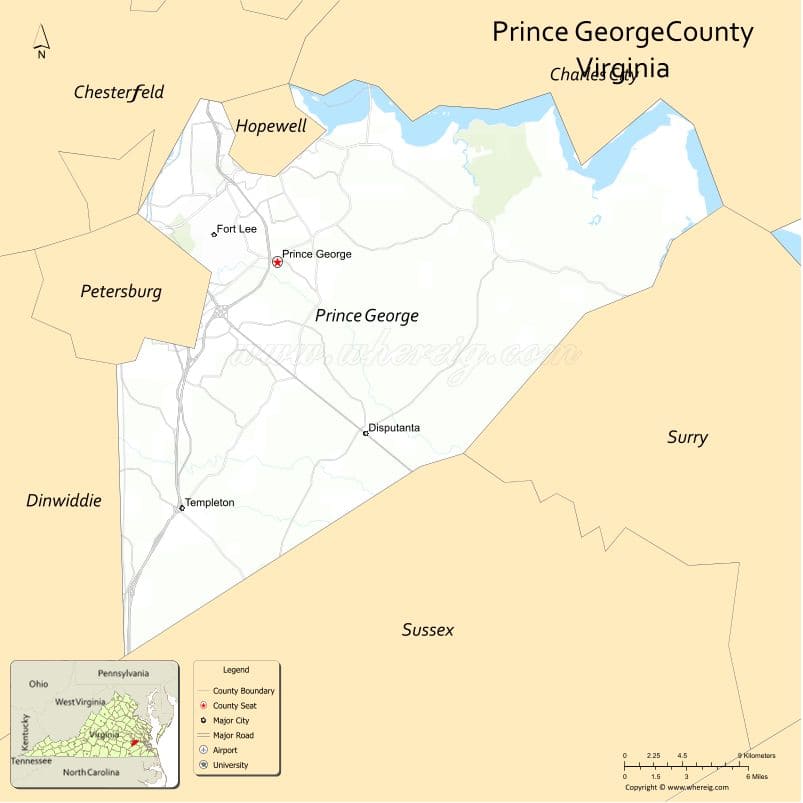
About Prince George County Map, Alabama: The map showing the county boundary, county seat, major cities, highways, water bodies and neighbouring counties.
Related Virginia Links
| Virginia Map | Counties in Virginia | Cities in Virginia |
| Airports in Virginia | Zip Codes in Virginia | Where is Virginia |
| Where is Richmond | Where is Chesapeake | Where is Virginia Beach |
Map of Prince George County, Virginia
Boone County is a county located in the U.S. state of West Virginia. It`s county seat is Madison. As per 2020 census, the population of Boone County was 21312 and population density of Boone was square miles. According to the United States Census Bureau, the county has a total area of 503 sq mi (1,303 km2). Boone County was established on 1847.
Prince George County Facts
| Continent | North America |
| Country | United States |
| State | Virginia |
| County Seat | Prince George |
| Largest City/Town | Prince George |
| Established | 1703 |
| Total Area | 282 sq mi (730 sq km) |
| Land Area | 265 sq mi (686 sq km) |
| Water Area | 17 sq mi (44 sq km) |
| Population | 40,343 (Census 2020) |
| Population Density | 152 people per sq mi |
| Time Zone | Eastern (EST) |
| Major Highways | I-95, I-295, US-460, VA-10 |
| Major Rivers | James River, Appomattox River |
| Neighboring Counties | Chesterfield County, Dinwiddie County, Sussex County, Surry County, Charles City County |
| Famous For | Fort Gregg-Adams (Fort Lee), military logistics, history |
| Top Attractions | Fort Gregg-Adams, Pamplin Historical Park, James River National Wildlife Refuge nearby |
| Official Website | Official Website |
About Prince George County, Virginia
Prince George County is located in the southeastern part of Virginia in the state of the United States, and was established in 1703. The county seat is Prince George, which is also the largest community. The county lies along the James and Appomattox rivers near the city of Petersburg and is known for its military installations, history, and strategic location.
Cities and Towns in Prince George County, Virginia
| City/Town | Population (Census 2020) | Latitude & Longitude |
|---|---|---|
| Prince George (county seat, CDP) | 2,500 | 37.2300°N, 77.2900°W |
| Disputanta (CDP) | 3,000 | 37.1000°N, 77.2600°W |
| Templeton (CDP) | 300 | 37.0300°N, 77.2700°W |
| Carson (CDP) | 900 | 37.0300°N, 77.4000°W |
| Birchvale (CDP) | 500 | 37.2500°N, 77.3300°W |
| New Bohemia (CDP) | 200 | 37.1800°N, 77.3300°W |
Golf Courses in Prince George County, Virginia
| Golf Course | Location | Latitude & Longitude |
|---|---|---|
| Dogwood Trace Golf Course | Fort Gregg-Adams | 37.2300°N, 77.3000°W |
| Jordan Point Country Club (nearby) | Prince George area | 37.2100°N, 77.2600°W |
Roads and Highways in Prince George County, Virginia
The county is a key transportation hub in southeastern Virginia.
- I-95 – major north-south interstate
- I-295 – bypass around Richmond area
- US-460 – important east-west route
- VA-10 – connects to surrounding counties
Neighboring Counties of Prince George County
- Chesterfield County (north)
- Charles City County (northeast)
- Surry County (east)
- Sussex County (south)
- Dinwiddie County (west)
Top Attractions in Prince George County, Virginia
The county offers history and outdoor recreation.
- Fort Gregg-Adams – major U.S. Army installation
- Pamplin Historical Park – Civil War history and museum
- James River – boating and fishing
- Appomattox River – scenic views and recreation
- Nearby wildlife refuges – nature and birdwatching
Distance from Prince George County to Nearby Cities
- Prince George to Richmond, VA – 25 mi (40 km)
- Prince George to Petersburg, VA – 10 mi (16 km)
- Prince George to Norfolk, VA – 85 mi (137 km)
- Prince George to Raleigh, NC – 130 mi (209 km)
- Prince George to Washington, DC – 140 mi (225 km)
FAQs about Prince George County
Prince George County is located in southeastern Virginia near the James and Appomattox rivers.
The population of Prince George County is 40,343 according to the 2020 Census.
The county is known for Fort Gregg-Adams and its military and historical significance.
The main highways include I-95, I-295, US-460, and Virginia Route 10.
Yes, Prince George County has golf courses such as Dogwood Trace Golf Course.
- Accomack County Map, VA
- Albemarle County Map, VA
- Alleghany County Map, VA
- Amelia County Map, VA
- Amherst County Map, VA
- Appomattox County Map, VA
- Arlington County Map, VA
- Augusta County Map, VA
- Bath County Map, VA
- Bedford County Map, VA
- Bland County Map, VA
- Botetourt County Map, VA
- Brunswick County Map, VA
- Buchanan County Map, VA
- Buckingham County Map, VA
- Campbell County Map, VA
- Caroline County Map, VA
- Carroll County Map, VA
- Charles City County Map, VA
- Charlotte County Map, VA
- Chesterfield County Map, VA
- Clarke County Map, VA
- Craig County Map, VA
- Culpeper County Map, VA
- Cumberland County Map, VA
- Dickenson County Map, VA
- Dinwiddie County Map, VA
- Essex County Map, VA
- Fairfax County Map, VA
- Fauquier County Map, VA
- Floyd County Map, VA
- Fluvanna County Map, VA
- Franklin County Map, VA
- Frederick County Map, VA
- Giles County Map, VA
- Gloucester County Map, VA
- Goochland County Map, VA
- Grayson County Map, VA
- Greene County Map, VA
- Greensville County Map, VA
- Halifax County Map, VA
- Hanover County Map, VA
- Henrico County Map, VA
- Henry County Map, VA
- Highland County Map, VA
- Isle of Wight County Map, VA
- James City County Map, VA
- King and Queen County Map, VA
- King George County Map, VA
- King William County Map, VA
- Lancaster County Map, VA
- Lee County Map, VA
- Loudoun County Map, VA
- Louisa County Map, VA
- Lunenburg County Map, VA
- Madison County Map, VA
- Mathews County Map, VA
- Mecklenburg County Map, VA
- Middlesex County Map, VA
- Montgomery County Map, VA
- Nelson County Map, VA
- New Kent County Map, VA
- Northampton County Map, VA
- Northumberland County Map, VA
- Nottoway County Map, VA
- Orange County Map, VA
- Page County Map, VA
- Patrick County Map, VA
- Pittsylvania County Map, VA
- Powhatan County Map, VA
- Prince Edward County Map, VA
- Prince George County Map, VA
- Prince William County Map, VA
- Pulaski County Map, VA
- Rappahannock County Map, VA
- Richmond County Map, VA
- Roanoke County Map, VA
- Rockbridge County Map, VA
- Rockingham County Map, VA
- Russell County Map, VA
- Scott County Map, VA
- Shenandoah County Map, VA
- Smyth County Map, VA
- Southampton County Map, VA
- Spotsylvania County Map, VA
- Stafford County Map, VA
- Surry County Map, VA
- Sussex County Map, VA
- Tazewell County Map, VA
- Warren County Map, VA
- Washington County Map, VA
- Westmoreland County Map, VA
- Wise County Map, VA
- Wythe County Map, VA
- York County Map, VA
- Alexandria County Map, VA
- Bristol County Map, VA
- Buena Vista County Map, VA
- Charlottesville County Map, VA
- Chesapeake County Map, VA
- Colonial Heights County Map, VA
- Covington County Map, VA
- Danville County Map, VA
- Emporia County Map, VA
- Fairfax County Map, VA
- Falls Church County Map, VA
- Alabama Counties
- Alaska boroughs
- Arizona Counties
- Arkansas Counties
- California County Map
- Colorado Counties
- Connecticut Counties
- Delaware Counties
- Florida County Map
- Georgia County Map
- Hawaii Counties
- Idaho Counties
- Illinois Counties
- Indiana Counties
- Iowa Counties
- Kansas Counties
- Kentucky Counties
- Louisiana Counties
- Maine Counties
- Maryland Counties
- Massachusetts Counties
- Michigan County Map
- Minnesota Counties
- Mississippi Counties
- Missouri Counties
- Montana Counties
- Nebraska Counties
- Nevada Counties
- New York Counties
- New Hampshire Counties
- New Jersey Counties
- New Mexico Counties
- North Carolina Counties
- North Dakota Counties
- Ohio County Map
- Oklahoma Counties
- Oregon Counties
- Pennsylvania Counties
- Rhode Island Counties
- South Carolina Counties
- South Dakota Counties
- Map of Tennessee
- Texas County Map
- Utah Counties
- Vermont Counties
- Virginia Counties
- Washington Counties
- West Virginia Counties
- Wisconsin Counties
- Wyoming Counties