Map of Douglas County - Douglas County is a county located in the U.S. state of Oregon. Douglas County Map showing cities, highways, important places and water bodies. Get Where is Douglas County located in the map, major cities in Douglas county, population, areas, and places of interest.
Map of Douglas County, Oregon
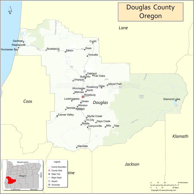
About Douglas County Map, Oregon: The map showing the county boundary, county seat, major cities, highways, water bodies and neighbouring counties.
Oregon More Maps & Info
About Douglas County, Oregon
Douglas County is a county located in the U.S. state of Oregon. It's county seat is Roseburg. As per 2020 census, the population of Douglas County is 111978 people and population density is square miles. According to the United States Census Bureau, the county has a total area of 5,037 sq mi (13,046 km2). Douglas County was established on 1852.
Douglas County Facts
| County Info | Facts |
|---|---|
| County | Douglas County |
| County Seat | Roseburg |
| State | Oregon |
| Country | United States |
| FIPS code | 19 |
| Established | 1852 |
| Area | 5,037 sq mi (13,046 km2) |
| Population | 111978 |
| Density | |
| Formed / Origin | Portion of Umpqua County which lay east of the Coast Range summit |
- Baker County Map
- Benton County Map
- Clackamas County Map
- Clatsop County Map
- Columbia County Map
- Coos County Map
- Crook County Map
- Curry County Map
- Deschutes County Map
- Douglas County Map
- Gilliam County Map
- Grant County Map
- Harney County Map
- Hood River County Map
- Jackson County Map
- Jefferson County Map
- Josephine County Map
- Klamath County Map
- Lake County Map
- Lane County Map
- Lincoln County Map
- Linn County Map
- Malheur County Map
- Marion County Map
- Morrow County Map
- Multnomah County Map
- Polk County Map
- Sherman County Map
- Tillamook County Map
- Umatilla County Map
- Union County Map
- Wallowa County Map
- Wasco County Map
- Washington County Map
- Wheeler County Map
- Yamhill County Map
- Alabama Counties
- Alaska boroughs
- Arizona Counties
- Arkansas Counties
- California County Map
- Colorado Counties
- Connecticut Counties
- Delaware Counties
- Florida County Map
- Georgia County Map
- Hawaii Counties
- Idaho Counties
- Illinois Counties
- Indiana Counties
- Iowa Counties
- Kansas Counties
- Kentucky Counties
- Louisiana Counties
- Maine Counties
- Maryland Counties
- Massachusetts Counties
- Michigan County Map
- Minnesota Counties
- Mississippi Counties
- Missouri Counties
- Montana Counties
- Nebraska Counties
- New Hampshire Counties
- New Jersey Counties
- New Mexico Counties
- North Carolina Counties
- North Dakota Counties
- Oklahoma Counties
- Oregon Counties
- Pennsylvania Counties
- Rhode Island Counties
- South Carolina Counties
- South Dakota Counties
- Map of Tennessee
- Texas County Map
- Utah Counties
- Vermont Counties
- Virginia Counties
- Washington Counties
- West Virginia Counties
- Wisconsin Counties
- Wyoming Counties
- Nevada Counties
- New York Counties
- Ohio County Map