Map of Polk County - Polk County is a county located in the U.S. state of Oregon. Polk County Map showing cities, highways, important places and water bodies. Get Where is Polk County located in the map, major cities in Polk county, population, areas, and places of interest.
Map of Polk County, Oregon
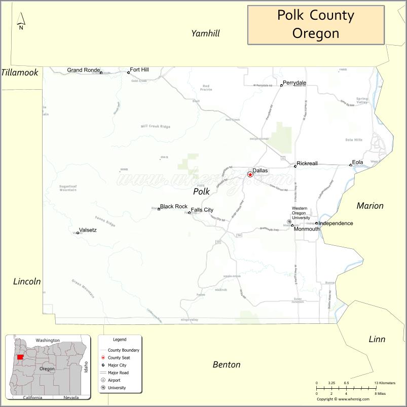
About Polk County Map, Oregon: The map showing the county boundary, county seat, major cities, highways, water bodies and neighbouring counties.
Oregon More Maps & Info
About Polk County, Oregon
Polk County is a county located in the U.S. state of Oregon. It's county seat is Dallas. As per 2020 census, the population of Polk County is 89164 people and population density is square miles. According to the United States Census Bureau, the county has a total area of 741 sq mi (1,919 km2). Polk County was established on 1845.
Polk County Facts
| Continent | North America |
| Country | United States |
| State | Oregon |
| County Seat | Dallas |
| Largest City/Town | Dallas |
| Established | 1845 |
| Total Area | 741 sq mi (1,919 sq km) |
| Land Area | 741 sq mi (1,919 sq km) |
| Water Area | 0.7 sq mi (2 sq km) |
| Population | 87,433 (Census 2020) |
| Population Density | 118.0 people per sq mi |
| Time Zone | Pacific Time Zone |
| Major Highways | Oregon Route 22, Oregon Route 99W, Oregon Route 223 |
| Major Rivers | Willamette River, Luckiamute River, Rickreall Creek |
| Neighboring Counties | Marion County, Yamhill County, Benton County, Lincoln County |
| Famous For | Willamette Valley vineyards, agriculture, historic towns, and scenic countryside |
| Top Attractions | Willamette Valley wineries, Baskett Slough National Wildlife Refuge, historic downtown Dallas, vineyards and farms |
| Official Website | Official Website |
About Polk County, Oregon
Polk County is located in western Oregon in the United States and was established in 1845. The county seat and largest city is Dallas. The county is known for fertile farmland, vineyards, scenic rolling hills, wildlife refuges, and small communities located in the Willamette Valley region.
Cities and Towns in Polk County, Oregon
| City/Town | Population (Census 2020) | Latitude & Longitude |
|---|---|---|
| Dallas (county seat) | 16,071 | 44.9193°N, 123.3170°W |
| Monmouth | 11,110 | 44.8482°N, 123.2340°W |
| Independence | 10,071 | 44.8515°N, 123.1868°W |
| Falls City | 974 | 44.8662°N, 123.4354°W |
| Willamina (partly in Polk County) | 2,313 | 45.0782°N, 123.4854°W |
| Rickreall | 1,315 | 45.0254°N, 123.2017°W |
| Eola | 522 | 44.9282°N, 123.1915°W |
| Buena Vista | 1,230 | 44.7970°N, 123.2948°W |
Golf Courses in Polk County, Oregon
| Golf Course | Location | Latitude & Longitude |
|---|---|---|
| Cross Creek Golf Course | Dallas | 44.9057°N, 123.3305°W |
| Eola Hills Wine Country Golf Club | Rickreall | 45.0148°N, 123.1990°W |
| Oak Knoll Golf Course | Independence | 44.8582°N, 123.1779°W |
Roads and Highways in Polk County, Oregon
Major highways connect the county to nearby regions and cities.
- Oregon Route 22 - major east-west highway linking Dallas with Salem and the Oregon Coast
- Oregon Route 99W - regional highway connecting Monmouth, Independence, and Willamette Valley communities
- Oregon Route 223 - scenic route serving western Polk County rural areas and small towns
Neighboring Counties of Polk County
- Yamhill County (north)
- Marion County (east)
- Benton County (south)
- Lincoln County (west)
Top Attractions in Polk County, Oregon
The county features several attractions known for history, nature, and recreation.
- Baskett Slough National Wildlife Refuge - wildlife refuge known for birdwatching and scenic trails
- Willamette Valley Vineyards nearby access - wine tasting region with vineyards and countryside scenery
- Historic Downtown Dallas - preserved historic district with shops, restaurants, and heritage buildings
- Western Oregon University - university campus located in Monmouth
- Buena Vista Ferry - historic cable ferry crossing the Willamette River
- Rickreall Creek Recreation Areas - outdoor recreation and countryside scenery
- Valley of the Giants nearby access - old-growth forest destination in the Coast Range
- Independence Riverfront Park - riverside recreation area with walking trails and events
Distance from Polk County to Nearby Cities
The following distances are measured by road (driving).
- Dallas to Salem (Marion County), Oregon - 16 mi (26 km)
- Dallas to Corvallis (Benton County), Oregon - 28 mi (45 km)
- Dallas to Eugene (Lane County), Oregon - 63 mi (101 km)
- Dallas to Newport (Lincoln County), Oregon - 74 mi (119 km)
- Dallas to Portland (Multnomah County), Oregon - 71 mi (114 km)
- Dallas to Albany (Linn County), Oregon - 39 mi (63 km)
- Dallas to Astoria (Clatsop County), Oregon - 105 mi (169 km)
- Dallas to Bend (Deschutes County), Oregon - 138 mi (222 km)
- Dallas to Medford (Jackson County), Oregon - 225 mi (362 km)
- Dallas to Florence (Lane County), Oregon - 96 mi (154 km)
- Dallas to Hood River (Hood River County), Oregon - 128 mi (206 km)
- Dallas to Coos Bay (Coos County), Oregon - 141 mi (227 km)
FAQs about Polk County
Polk County is located in western Oregon in the Willamette Valley region.
Polk County had a population of 87,433 according to Census 2020 data.
Polk County is known for vineyards, agriculture, scenic countryside, and Willamette Valley communities.
The county is served by Oregon Route 22, Oregon Route 99W, and Oregon Route 223.
Yes, Polk County has golf facilities including Cross Creek Golf Course and Eola Hills Wine Country Golf Club.
- Baker County Map
- Benton County Map
- Clackamas County Map
- Clatsop County Map
- Columbia County Map
- Coos County Map
- Crook County Map
- Curry County Map
- Deschutes County Map
- Douglas County Map
- Gilliam County Map
- Grant County Map
- Harney County Map
- Hood River County Map
- Jackson County Map
- Jefferson County Map
- Josephine County Map
- Klamath County Map
- Lake County Map
- Lane County Map
- Lincoln County Map
- Linn County Map
- Malheur County Map
- Marion County Map
- Morrow County Map
- Multnomah County Map
- Polk County Map
- Sherman County Map
- Tillamook County Map
- Umatilla County Map
- Union County Map
- Wallowa County Map
- Wasco County Map
- Washington County Map
- Wheeler County Map
- Yamhill County Map
- Alabama Counties
- Alaska boroughs
- Arizona Counties
- Arkansas Counties
- California County Map
- Colorado Counties
- Connecticut Counties
- Delaware Counties
- Florida County Map
- Georgia County Map
- Hawaii Counties
- Idaho Counties
- Illinois Counties
- Indiana Counties
- Iowa Counties
- Kansas Counties
- Kentucky Counties
- Louisiana Counties
- Maine Counties
- Maryland Counties
- Massachusetts Counties
- Michigan County Map
- Minnesota Counties
- Mississippi Counties
- Missouri Counties
- Montana Counties
- Nebraska Counties
- Nevada Counties
- New York Counties
- New Hampshire Counties
- New Jersey Counties
- New Mexico Counties
- North Carolina Counties
- North Dakota Counties
- Ohio County Map
- Oklahoma Counties
- Oregon Counties
- Pennsylvania Counties
- Rhode Island Counties
- South Carolina Counties
- South Dakota Counties
- Map of Tennessee
- Texas County Map
- Utah Counties
- Vermont Counties
- Virginia Counties
- Washington Counties
- West Virginia Counties
- Wisconsin Counties
- Wyoming Counties