Map of Josephine County - Josephine County is a county located in the U.S. state of Oregon. Josephine County Map showing cities, highways, important places and water bodies. Get Where is Josephine County located in the map, major cities in Josephine county, population, areas, and places of interest.
Map of Josephine County, Oregon
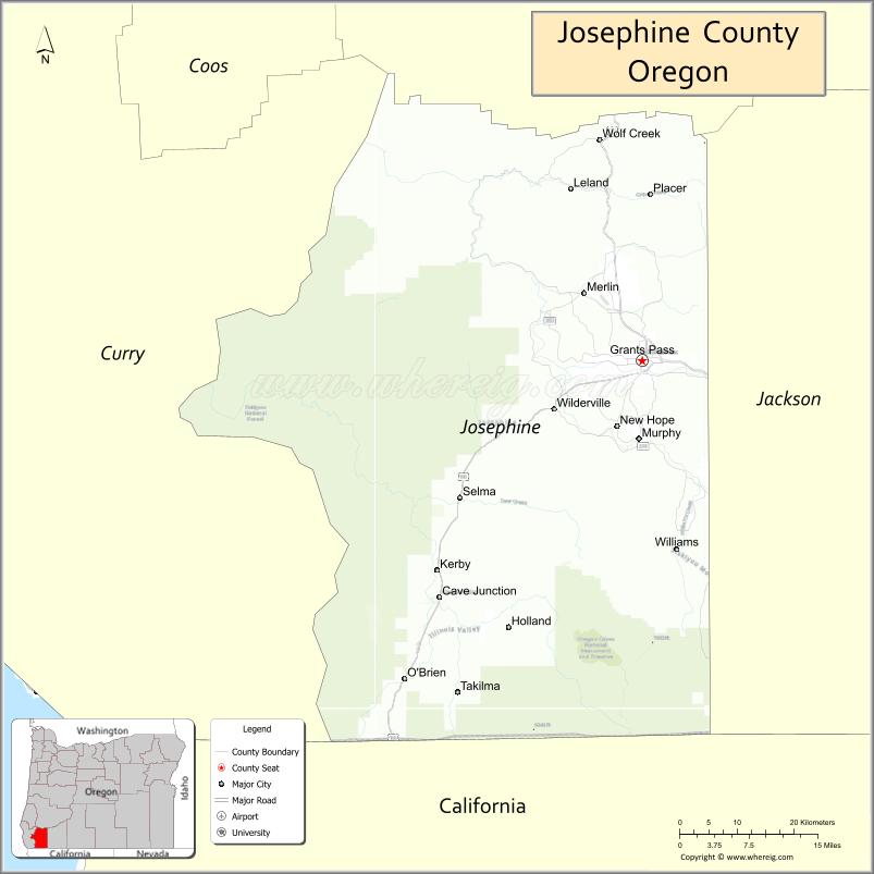
About Josephine County Map, Oregon: The map showing the county boundary, county seat, major cities, highways, water bodies and neighbouring counties.
Oregon More Maps & Info
About Josephine County, Oregon
Josephine County is a county located in the U.S. state of Oregon. It's county seat is Grants Pass. As per 2020 census, the population of Josephine County is 88346 people and population density is square miles. According to the United States Census Bureau, the county has a total area of 1,640 sq mi (4,248 km2). Josephine County was established on 1856.
Josephine County Facts
| Continent | North America |
| Country | United States |
| State | Oregon |
| County Seat | Grants Pass |
| Largest City/Town | Grants Pass |
| Established | 1856 |
| Total Area | 1,642 sq mi (4,253 sq km) |
| Land Area | 1,640 sq mi (4,248 sq km) |
| Water Area | 2 sq mi (5 sq km) |
| Population | 88,090 (Census 2020) |
| Population Density | 53.7 people per sq mi |
| Time Zone | Pacific Time Zone |
| Major Highways | Interstate 5, U.S. Route 199, Oregon Route 238 |
| Major Rivers | Rogue River, Illinois River, Applegate River |
| Neighboring Counties | Douglas County, Jackson County, Curry County, Del Norte County (CA), Siskiyou County (CA) |
| Famous For | Rogue River recreation, caves, forests, rafting, and scenic mountain landscapes |
| Top Attractions | Oregon Caves National Monument, Rogue River, Hellgate Canyon, Illinois Valley, wildlife recreation areas |
| Official Website | Official Website |
About Josephine County, Oregon
Josephine County is located in southwestern Oregon in the United States and was established in 1856. The county seat and largest city is Grants Pass. The county is known for scenic river canyons, mountain forests, outdoor adventure recreation, and historic communities located throughout the Rogue and Illinois River valleys.
Cities and Towns in Josephine County, Oregon
| City/Town | Population (Census 2020) | Latitude & Longitude |
|---|---|---|
| Grants Pass (county seat) | 39,189 | 42.4390°N, 123.3284°W |
| Cave Junction | 2,071 | 42.1637°N, 123.6487°W |
| Wilderville | 1,010 | 42.3651°N, 123.4181°W |
| Merlin (CDP) | 1,615 | 42.5179°N, 123.4198°W |
| Williams (CDP) | 1,072 | 42.2173°N, 123.2867°W |
| Murphy (CDP) | 1,248 | 42.3418°N, 123.3329°W |
| Selma (CDP) | 695 | 42.2782°N, 123.6142°W |
| Wolf Creek (CDP) | 230 | 42.6595°N, 123.3911°W |
| O'Brien (CDP) | 504 | 42.0678°N, 123.7064°W |
Golf Courses in Josephine County, Oregon
| Golf Course | Location | Latitude & Longitude |
|---|---|---|
| Grants Pass Golf Club | Grants Pass | 42.4288°N, 123.3112°W |
| Dutcher Creek Golf Course | Cave Junction | 42.1764°N, 123.6525°W |
| Laurel Hill Golf Course | Grants Pass | 42.4491°N, 123.3404°W |
| River Valley Golf Course | Grants Pass | 42.4538°N, 123.3369°W |
Roads and Highways in Josephine County, Oregon
Major highways connect the county to nearby regions and cities.
- Interstate 5 - major north-south highway connecting Grants Pass with Medford, Roseburg, and California
- U.S. Route 199 - scenic route linking Grants Pass with Crescent City, California and the Pacific Coast
- Oregon Route 238 - connects Grants Pass with Applegate Valley communities and Jackson County
Neighboring Counties of Josephine County
- Douglas County (north)
- Jackson County (east)
- Curry County (west)
- Del Norte County, California (southwest)
- Siskiyou County, California (south)
Top Attractions in Josephine County, Oregon
The county features several attractions known for history, nature, and recreation.
- Oregon Caves National Monument and Preserve - marble cave system with guided tours and hiking trails
- Rogue River - world-famous river destination for rafting, fishing, and scenic boat tours
- Hellgate Canyon - dramatic river canyon explored by jet boat excursions
- Illinois Valley - scenic valley known for forests, vineyards, and outdoor recreation
- Cathedral Hills Trails - hiking and mountain biking area near Grants Pass
- Wild River Brewing and local wineries - regional tasting destinations and craft beverage attractions
- Lake Selmac Recreation Area - boating, camping, and fishing destination
- Historic Wolf Creek Inn - preserved pioneer-era inn and Oregon heritage site
Distance from Josephine County to Nearby Cities
The following distances are measured by road (driving).
- Grants Pass to Medford (Jackson County), Oregon - 30 mi (48 km)
- Grants Pass to Roseburg (Douglas County), Oregon - 70 mi (113 km)
- Grants Pass to Crescent City (Del Norte County), California - 84 mi (135 km)
- Grants Pass to Coos Bay (Coos County), Oregon - 120 mi (193 km)
- Grants Pass to Klamath Falls (Klamath County), Oregon - 104 mi (167 km)
- Grants Pass to Eugene (Lane County), Oregon - 141 mi (227 km)
- Grants Pass to Bend (Deschutes County), Oregon - 203 mi (327 km)
- Grants Pass to Redding (Shasta County), California - 120 mi (193 km)
- Grants Pass to Salem (Marion County), Oregon - 212 mi (341 km)
- Grants Pass to Portland (Multnomah County), Oregon - 247 mi (398 km)
- Grants Pass to Brookings (Curry County), Oregon - 87 mi (140 km)
- Grants Pass to Sacramento (Sacramento County), California - 262 mi (422 km)
FAQs about Josephine County
Josephine County is located in southwestern Oregon near the California border.
Josephine County had a population of 88,090 according to Census 2020 data.
Josephine County is known for the Rogue River, scenic caves, rafting, forests, and outdoor recreation.
The county is served by Interstate 5, U.S. Route 199, and Oregon Route 238.
Yes, Josephine County has several golf facilities including Grants Pass Golf Club and Dutcher Creek Golf Course.
- Baker County Map
- Benton County Map
- Clackamas County Map
- Clatsop County Map
- Columbia County Map
- Coos County Map
- Crook County Map
- Curry County Map
- Deschutes County Map
- Douglas County Map
- Gilliam County Map
- Grant County Map
- Harney County Map
- Hood River County Map
- Jackson County Map
- Jefferson County Map
- Josephine County Map
- Klamath County Map
- Lake County Map
- Lane County Map
- Lincoln County Map
- Linn County Map
- Malheur County Map
- Marion County Map
- Morrow County Map
- Multnomah County Map
- Polk County Map
- Sherman County Map
- Tillamook County Map
- Umatilla County Map
- Union County Map
- Wallowa County Map
- Wasco County Map
- Washington County Map
- Wheeler County Map
- Yamhill County Map
- Alabama Counties
- Alaska boroughs
- Arizona Counties
- Arkansas Counties
- California County Map
- Colorado Counties
- Connecticut Counties
- Delaware Counties
- Florida County Map
- Georgia County Map
- Hawaii Counties
- Idaho Counties
- Illinois Counties
- Indiana Counties
- Iowa Counties
- Kansas Counties
- Kentucky Counties
- Louisiana Counties
- Maine Counties
- Maryland Counties
- Massachusetts Counties
- Michigan County Map
- Minnesota Counties
- Mississippi Counties
- Missouri Counties
- Montana Counties
- Nebraska Counties
- Nevada Counties
- New York Counties
- New Hampshire Counties
- New Jersey Counties
- New Mexico Counties
- North Carolina Counties
- North Dakota Counties
- Ohio County Map
- Oklahoma Counties
- Oregon Counties
- Pennsylvania Counties
- Rhode Island Counties
- South Carolina Counties
- South Dakota Counties
- Map of Tennessee
- Texas County Map
- Utah Counties
- Vermont Counties
- Virginia Counties
- Washington Counties
- West Virginia Counties
- Wisconsin Counties
- Wyoming Counties