Map of Tillamook County - Tillamook County is a county located in the U.S. state of Oregon. Tillamook County Map showing cities, highways, important places and water bodies. Get Where is Tillamook County located in the map, major cities in Tillamook county, population, areas, and places of interest.
Map of Tillamook County, Oregon
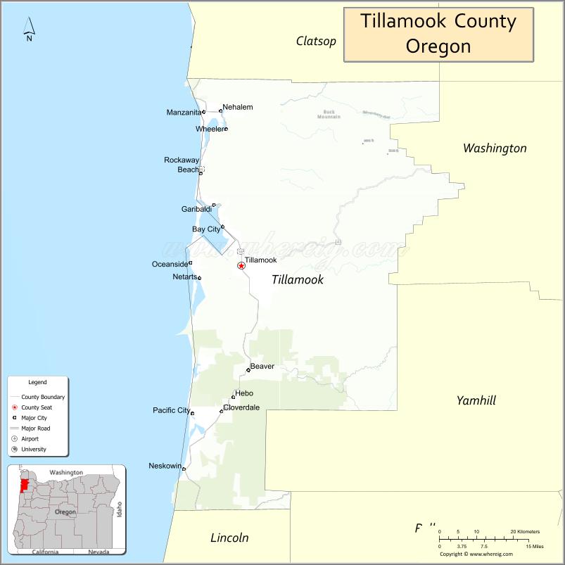
About Tillamook County Map, Oregon: The map showing the county boundary, county seat, major cities, highways, water bodies and neighbouring counties.
Oregon More Maps & Info
About Tillamook County, Oregon
Tillamook County is a county located in the U.S. state of Oregon. It's county seat is Tillamook. As per 2020 census, the population of Tillamook County is 27748 people and population density is square miles. According to the United States Census Bureau, the county has a total area of 1,102 sq mi (2,854 km2). Tillamook County was established on 1853.
Tillamook County Facts
| Continent | North America |
| Country | United States |
| State | Oregon |
| County Seat | Tillamook |
| Largest City/Town | Tillamook |
| Established | 1853 |
| Total Area | 1,332 sq mi (3,450 sq km) |
| Land Area | 1,103 sq mi (2,857 sq km) |
| Water Area | 229 sq mi (593 sq km) |
| Population | 27,390 (Census 2020) |
| Population Density | 24.8 people per sq mi |
| Time Zone | Pacific Time Zone |
| Major Highways | U.S. Route 101, Oregon Route 6, Oregon Route 22, Oregon Route 53 |
| Major Rivers | Wilson River, Trask River, Nehalem River, Tillamook River |
| Neighboring Counties | Clatsop County, Washington County, Yamhill County, Polk County, Lincoln County |
| Famous For | Oregon Coast beaches, dairy farming, Tillamook Creamery, and scenic coastal landscapes |
| Top Attractions | Tillamook Creamery, Cannon Beach nearby access, Cape Meares, Three Capes Scenic Route, Oregon Coast beaches |
| Official Website | Official Website |
About Tillamook County, Oregon
Tillamook County is located on the northern Oregon Coast in the United States and was established in 1853. The county seat and largest city is Tillamook. The county is known for rugged coastline, dairy farms, forests, scenic bays, seafood, and outdoor recreation along the Pacific Ocean.
Cities and Towns in Tillamook County, Oregon
| City/Town | Population (Census 2020) | Latitude & Longitude |
|---|---|---|
| Tillamook (county seat) | 5,231 | 45.4562°N, 123.8426°W |
| Bay City | 1,286 | 45.5229°N, 123.8896°W |
| Garibaldi | 820 | 45.5587°N, 123.9168°W |
| Manzanita | 607 | 45.7184°N, 123.9351°W |
| Nehalem | 271 | 45.7202°N, 123.8929°W |
| Neskowin | 170 | 45.1087°N, 123.9718°W |
| Netarts | 744 | 45.4315°N, 123.9454°W |
| Oceanside | 455 | 45.4643°N, 123.9687°W |
| Pacific City | 1,076 | 45.2046°N, 123.9626°W |
| Rockaway Beach | 1,441 | 45.6137°N, 123.9446°W |
| Wheeler | 414 | 45.6890°N, 123.8801°W |
Golf Courses in Tillamook County, Oregon
| Golf Course | Location | Latitude & Longitude |
|---|---|---|
| Manzanita Golf Course | Manzanita | 45.7221°N, 123.9320°W |
| Alderbrook Golf Course | Tillamook | 45.4510°N, 123.8195°W |
| Neskowin Beach Golf Course | Neskowin | 45.1096°N, 123.9695°W |
Roads and Highways in Tillamook County, Oregon
Major highways connect the county to nearby regions and cities.
- U.S. Route 101 - major coastal highway connecting Tillamook County communities along the Pacific Coast
- Oregon Route 6 - scenic route linking Tillamook with Portland and the northern Willamette Valley
- Oregon Route 22 - connects southern county areas with Salem and central Oregon routes
- Oregon Route 53 - highway serving inland forest and recreation areas
Neighboring Counties of Tillamook County
- Clatsop County (north)
- Washington County (east)
- Yamhill County (southeast)
- Polk County (south)
- Lincoln County (south)
Top Attractions in Tillamook County, Oregon
The county features several attractions known for nature, recreation, and coastal scenery.
- Tillamook Creamery - famous dairy attraction featuring cheese production tours and local products
- Cape Meares State Scenic Viewpoint - coastal headland with lighthouse and ocean views
- Three Capes Scenic Route - scenic driving route featuring beaches, cliffs, and forests
- Pacific City and Haystack Rock - popular surfing and beach recreation destination
- Tillamook Air Museum - aviation museum housed in a historic blimp hangar
- Netarts Bay - kayaking, crabbing, and shellfish harvesting area
- Nehalem Bay State Park - camping and beach recreation destination
- Oceanside Beach State Recreation Site - scenic beach known for sea stacks and coastal views
Distance from Tillamook County to Nearby Cities
The following distances are measured by road (driving).
- Tillamook to Portland (Multnomah County), Oregon - 74 mi (119 km)
- Tillamook to Salem (Marion County), Oregon - 88 mi (142 km)
- Tillamook to Astoria (Clatsop County), Oregon - 61 mi (98 km)
- Tillamook to Newport (Lincoln County), Oregon - 73 mi (117 km)
- Tillamook to Eugene (Lane County), Oregon - 136 mi (219 km)
- Tillamook to Corvallis (Benton County), Oregon - 98 mi (158 km)
- Tillamook to Bend (Deschutes County), Oregon - 184 mi (296 km)
- Tillamook to Hood River (Hood River County), Oregon - 132 mi (212 km)
- Tillamook to Medford (Jackson County), Oregon - 289 mi (465 km)
- Tillamook to Seattle (King County), Washington - 221 mi (356 km)
- Tillamook to Coos Bay (Coos County), Oregon - 176 mi (283 km)
- Tillamook to Klamath Falls (Klamath County), Oregon - 308 mi (496 km)
FAQs about Tillamook County
Tillamook County is located on the northern Oregon Coast along the Pacific Ocean.
Tillamook County had a population of 27,390 according to Census 2020 data.
Tillamook County is known for dairy farming, coastal scenery, beaches, and the famous Tillamook Creamery.
The county is served by U.S. Route 101, Oregon Route 6, Oregon Route 22, and Oregon Route 53.
Yes, Tillamook County has golf facilities including Manzanita Golf Course and Alderbrook Golf Course.
- Baker County Map
- Benton County Map
- Clackamas County Map
- Clatsop County Map
- Columbia County Map
- Coos County Map
- Crook County Map
- Curry County Map
- Deschutes County Map
- Douglas County Map
- Gilliam County Map
- Grant County Map
- Harney County Map
- Hood River County Map
- Jackson County Map
- Jefferson County Map
- Josephine County Map
- Klamath County Map
- Lake County Map
- Lane County Map
- Lincoln County Map
- Linn County Map
- Malheur County Map
- Marion County Map
- Morrow County Map
- Multnomah County Map
- Polk County Map
- Sherman County Map
- Tillamook County Map
- Umatilla County Map
- Union County Map
- Wallowa County Map
- Wasco County Map
- Washington County Map
- Wheeler County Map
- Yamhill County Map
- Alabama Counties
- Alaska boroughs
- Arizona Counties
- Arkansas Counties
- California County Map
- Colorado Counties
- Connecticut Counties
- Delaware Counties
- Florida County Map
- Georgia County Map
- Hawaii Counties
- Idaho Counties
- Illinois Counties
- Indiana Counties
- Iowa Counties
- Kansas Counties
- Kentucky Counties
- Louisiana Counties
- Maine Counties
- Maryland Counties
- Massachusetts Counties
- Michigan County Map
- Minnesota Counties
- Mississippi Counties
- Missouri Counties
- Montana Counties
- Nebraska Counties
- Nevada Counties
- New York Counties
- New Hampshire Counties
- New Jersey Counties
- New Mexico Counties
- North Carolina Counties
- North Dakota Counties
- Ohio County Map
- Oklahoma Counties
- Oregon Counties
- Pennsylvania Counties
- Rhode Island Counties
- South Carolina Counties
- South Dakota Counties
- Map of Tennessee
- Texas County Map
- Utah Counties
- Vermont Counties
- Virginia Counties
- Washington Counties
- West Virginia Counties
- Wisconsin Counties
- Wyoming Counties