Map of Lake County - Lake County is a county located in the U.S. state of Oregon. Lake County Map showing cities, highways, important places and water bodies. Get Where is Lake County located in the map, major cities in Lake county, population, areas, and places of interest.
Map of Lake County, Oregon
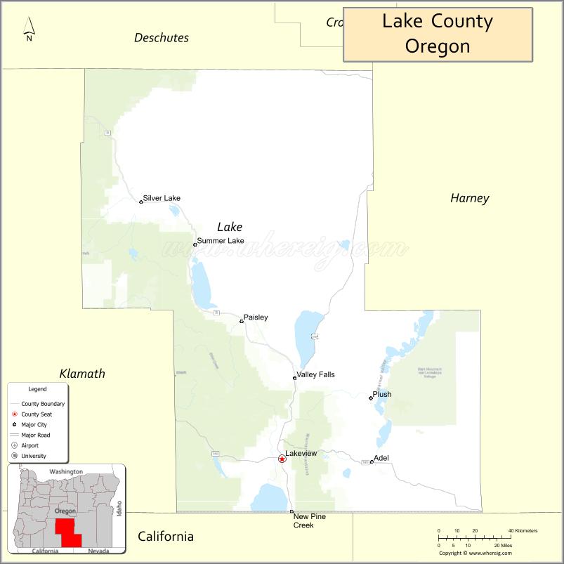
About Lake County Map, Oregon: The map showing the county boundary, county seat, major cities, highways, water bodies and neighbouring counties.
Oregon More Maps & Info
About Lake County, Oregon
Lake County is a county located in the U.S. state of Oregon. It's county seat is Lakeview. As per 2020 census, the population of Lake County is 8276 people and population density is square miles. According to the United States Census Bureau, the county has a total area of 7,940 sq mi (20,565 km2). Lake County was established on 1874.
Lake County Facts
| Continent | North America |
| Country | United States |
| State | Oregon |
| County Seat | Lakeview |
| Largest City/Town | Lakeview |
| Established | 1874 |
| Total Area | 8,358 sq mi (21,647 sq km) |
| Land Area | 8,139 sq mi (21,080 sq km) |
| Water Area | 219 sq mi (567 sq km) |
| Population | 8,160 (Census 2020) |
| Population Density | 1.0 people per sq mi |
| Time Zone | Pacific Time Zone |
| Major Highways | U.S. Route 395, Oregon Route 31, Oregon Route 140 |
| Major Rivers | Chewaucan River, Sprague River, Williamson River |
| Neighboring Counties | Klamath County, Harney County, Deschutes County, Crook County, Modoc County (CA), Washoe County (NV) |
| Famous For | High desert landscapes, alkali lakes, hot springs, ranching, and remote wilderness |
| Top Attractions | Summer Lake, Hart Mountain National Antelope Refuge, Warner Mountains, Paisley Caves, Goose Lake |
| Official Website | Official Website |
About Lake County, Oregon
Lake County is located in south-central Oregon in the United States and was established in 1874. The county seat and largest city is Lakeview. The county is known for vast high desert scenery, mountain ranges, wildlife refuges, hot springs, and remote outdoor recreation opportunities across southeastern Oregon.
Cities and Towns in Lake County, Oregon
| City/Town | Population (Census 2020) | Latitude & Longitude |
|---|---|---|
| Lakeview (county seat) | 2,294 | 42.1888°N, 120.3458°W |
| Paisley | 243 | 42.6935°N, 120.5455°W |
| Silver Lake | 149 | 43.1260°N, 121.0675°W |
| Christmas Valley | 1,074 | 43.2368°N, 120.7501°W |
| Fort Rock | Not Incorporated | 43.3574°N, 121.0547°W |
| Summer Lake | 105 | 42.9796°N, 120.7856°W |
| Plush | 57 | 42.3963°N, 119.9078°W |
| New Pine Creek | 120 | 42.0006°N, 120.2869°W |
Golf Courses in Lake County, Oregon
| Golf Course | Location | Latitude & Longitude |
|---|---|---|
| Lakeview Golf Course | Lakeview | 42.1963°N, 120.3557°W |
| Desert Whispers Golf Course | Christmas Valley | 43.2361°N, 120.7493°W |
Roads and Highways in Lake County, Oregon
Major highways connect the county to nearby regions and cities.
- U.S. Route 395 - major north-south highway linking Lakeview with Burns, Klamath Falls, and California
- Oregon Route 31 - scenic route connecting Summer Lake, Paisley, and central Oregon desert regions
- Oregon Route 140 - connects Lakeview with Klamath Falls and Nevada routes
Neighboring Counties of Lake County
- Deschutes County (northwest)
- Crook County (north)
- Harney County (east)
- Klamath County (west)
- Modoc County, California (southwest)
- Washoe County, Nevada (south)
Top Attractions in Lake County, Oregon
The county features several attractions known for history, nature, and recreation.
- Hart Mountain National Antelope Refuge - wildlife refuge known for pronghorn antelope and remote desert scenery
- Summer Lake Hot Springs - natural hot springs destination with mountain views
- Paisley Caves - important archaeological site featuring early human history discoveries
- Warner Mountains - scenic mountain range popular for hiking and camping
- Goose Lake - large seasonal lake along the Oregon-California border
- Fort Rock State Natural Area - volcanic formation and geological landmark in the high desert
- Abert Rim nearby access - dramatic fault escarpment popular for photography and hang gliding
- Crack in the Ground - volcanic fissure and hiking destination near Christmas Valley
Distance from Lake County to Nearby Cities
The following distances are measured by road (driving).
- Lakeview to Klamath Falls (Klamath County), Oregon - 96 mi (154 km)
- Lakeview to Burns (Harney County), Oregon - 129 mi (208 km)
- Lakeview to Bend (Deschutes County), Oregon - 190 mi (306 km)
- Lakeview to Medford (Jackson County), Oregon - 171 mi (275 km)
- Lakeview to Reno (Washoe County), Nevada - 178 mi (286 km)
- Lakeview to Alturas (Modoc County), California - 54 mi (87 km)
- Lakeview to Eugene (Lane County), Oregon - 285 mi (459 km)
- Lakeview to Salem (Marion County), Oregon - 312 mi (502 km)
- Lakeview to Portland (Multnomah County), Oregon - 347 mi (558 km)
- Lakeview to Boise (Ada County), Idaho - 355 mi (571 km)
- Lakeview to Sacramento (Sacramento County), California - 312 mi (502 km)
- Lakeview to Susanville (Lassen County), California - 128 mi (206 km)
FAQs about Lake County
Lake County is located in south-central Oregon near the California and Nevada borders.
Lake County had a population of 8,160 according to Census 2020 data.
Lake County is known for high desert landscapes, hot springs, remote wilderness, and wildlife refuges.
The county is served by U.S. Route 395, Oregon Route 31, and Oregon Route 140.
Yes, Lake County has golf facilities including Lakeview Golf Course and Desert Whispers Golf Course.
- Baker County Map
- Benton County Map
- Clackamas County Map
- Clatsop County Map
- Columbia County Map
- Coos County Map
- Crook County Map
- Curry County Map
- Deschutes County Map
- Douglas County Map
- Gilliam County Map
- Grant County Map
- Harney County Map
- Hood River County Map
- Jackson County Map
- Jefferson County Map
- Josephine County Map
- Klamath County Map
- Lake County Map
- Lane County Map
- Lincoln County Map
- Linn County Map
- Malheur County Map
- Marion County Map
- Morrow County Map
- Multnomah County Map
- Polk County Map
- Sherman County Map
- Tillamook County Map
- Umatilla County Map
- Union County Map
- Wallowa County Map
- Wasco County Map
- Washington County Map
- Wheeler County Map
- Yamhill County Map
- Alabama Counties
- Alaska boroughs
- Arizona Counties
- Arkansas Counties
- California County Map
- Colorado Counties
- Connecticut Counties
- Delaware Counties
- Florida County Map
- Georgia County Map
- Hawaii Counties
- Idaho Counties
- Illinois Counties
- Indiana Counties
- Iowa Counties
- Kansas Counties
- Kentucky Counties
- Louisiana Counties
- Maine Counties
- Maryland Counties
- Massachusetts Counties
- Michigan County Map
- Minnesota Counties
- Mississippi Counties
- Missouri Counties
- Montana Counties
- Nebraska Counties
- Nevada Counties
- New York Counties
- New Hampshire Counties
- New Jersey Counties
- New Mexico Counties
- North Carolina Counties
- North Dakota Counties
- Ohio County Map
- Oklahoma Counties
- Oregon Counties
- Pennsylvania Counties
- Rhode Island Counties
- South Carolina Counties
- South Dakota Counties
- Map of Tennessee
- Texas County Map
- Utah Counties
- Vermont Counties
- Virginia Counties
- Washington Counties
- West Virginia Counties
- Wisconsin Counties
- Wyoming Counties