Map of Lane County - Lane County is a county located in the U.S. state of Oregon. Lane County Map showing cities, highways, important places and water bodies. Get Where is Lane County located in the map, major cities in Lane county, population, areas, and places of interest.
Map of Lane County, Oregon
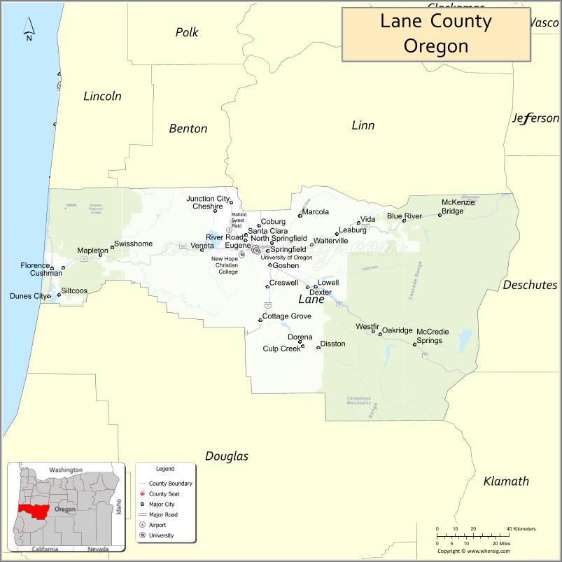
About Lane County Map, Oregon: The map showing the county boundary, county seat, major cities, highways, water bodies and neighbouring counties.
Oregon More Maps & Info
About Lane County, Oregon
Lane County is a county located in the U.S. state of Oregon. It's county seat is Eugene. As per 2020 census, the population of Lane County is 383189 people and population density is square miles. According to the United States Census Bureau, the county has a total area of 4,554 sq mi (11,795 km2). Lane County was established on 1851.
Lane County Facts
| Continent | North America |
| Country | United States |
| State | Oregon |
| County Seat | Eugene |
| Largest City/Town | Eugene |
| Established | 1851 |
| Total Area | 4,722 sq mi (12,230 sq km) |
| Land Area | 4,553 sq mi (11,792 sq km) |
| Water Area | 169 sq mi (438 sq km) |
| Population | 382,971 (Census 2020) |
| Population Density | 84.1 people per sq mi |
| Time Zone | Pacific Time Zone |
| Major Highways | Interstate 5, U.S. Route 101, Oregon Route 126, Oregon Route 58 |
| Major Rivers | Willamette River, McKenzie River, Siuslaw River, Coast Fork Willamette River |
| Neighboring Counties | Benton County, Linn County, Douglas County, Deschutes County, Coos County, Lincoln County |
| Famous For | University of Oregon, forests, rivers, coastal scenery, and outdoor recreation |
| Top Attractions | University of Oregon, Oregon Coast access, Mount Pisgah, Cascades recreation, Heceta Head Lighthouse |
| Official Website | Official Website |
About Lane County, Oregon
Lane County is located in western Oregon in the United States and was established in 1851. The county seat and largest city is Eugene. The county stretches from the Pacific Coast to the Cascade Mountains and is known for forests, rivers, university culture, coastal scenery, and outdoor recreation opportunities.
Cities and Towns in Lane County, Oregon
| City/Town | Population (Census 2020) | Latitude & Longitude |
|---|---|---|
| Eugene (county seat) | 176,654 | 44.0521°N, 123.0868°W |
| Cottage Grove | 10,729 | 43.7976°N, 123.0595°W |
| Creswell | 5,855 | 43.9179°N, 123.0243°W |
| Florence | 9,396 | 43.9826°N, 124.0998°W |
| Junction City | 6,747 | 44.2190°N, 123.2057°W |
| Lowell | 1,002 | 43.9185°N, 122.7837°W |
| Oakridge | 3,243 | 43.7465°N, 122.4612°W |
| Springfield | 62,698 | 44.0462°N, 123.0220°W |
| Veneta | 5,187 | 44.0423°N, 123.3509°W |
| Westfir | 276 | 43.7601°N, 122.4987°W |
| Coburg | 1,306 | 44.1371°N, 123.0556°W |
| Dunes City | 1,304 | 44.1192°N, 124.1097°W |
| Elmira | 2,979 | 44.0687°N, 123.3581°W |
| Mapleton | 715 | 44.0340°N, 123.8571°W |
Golf Courses in Lane County, Oregon
| Golf Course | Location | Latitude & Longitude |
|---|---|---|
| Eugene Country Club | Eugene | 44.0884°N, 123.1195°W |
| Emerald Valley Golf Club | Creswell | 43.9145°N, 123.0249°W |
| Tokatee Golf Club | Blue River | 44.1504°N, 122.2349°W |
| Florence Golf Links | Florence | 43.9977°N, 124.1104°W |
| Laurelwood Golf Course | Eugene | 44.0293°N, 123.0915°W |
| Middlefield Golf Course | Cottage Grove | 43.7815°N, 123.0576°W |
| Oakway Golf Course | Eugene | 44.0688°N, 123.0803°W |
Roads and Highways in Lane County, Oregon
Major highways connect the county to nearby regions and cities.
- Interstate 5 - major north-south highway connecting Eugene with Portland, Salem, and southern Oregon
- U.S. Route 101 - coastal highway serving Florence and Pacific shoreline communities
- Oregon Route 126 - links Eugene with the Oregon Coast and Cascade Mountain recreation areas
- Oregon Route 58 - scenic route connecting Eugene with central and southern Oregon regions
Neighboring Counties of Lane County
- Benton County (north)
- Linn County (northeast)
- Deschutes County (east)
- Douglas County (south)
- Coos County (southwest)
- Lincoln County (northwest)
Top Attractions in Lane County, Oregon
The county features several attractions known for history, nature, and recreation.
- University of Oregon - major university campus known for academics, athletics, and cultural events
- Heceta Head Lighthouse - scenic coastal landmark near Florence with ocean views
- Mount Pisgah Arboretum - nature area with hiking trails and native plant collections
- McKenzie River Recreation Area - destination for fishing, rafting, waterfalls, and hiking
- Oregon Dunes National Recreation Area - coastal dune system popular for off-road recreation
- Autzen Stadium - home stadium of the Oregon Ducks football team
- Spencer Butte - hiking destination with panoramic views of Eugene and the Willamette Valley
- Sahalie and Koosah Falls nearby access - scenic waterfalls along the McKenzie River corridor
Distance from Lane County to Nearby Cities
The following distances are measured by road (driving).
- Eugene to Springfield (Lane County), Oregon - 5 mi (8 km)
- Eugene to Salem (Marion County), Oregon - 66 mi (106 km)
- Eugene to Corvallis (Benton County), Oregon - 47 mi (76 km)
- Eugene to Florence (Lane County), Oregon - 61 mi (98 km)
- Eugene to Bend (Deschutes County), Oregon - 128 mi (206 km)
- Eugene to Roseburg (Douglas County), Oregon - 69 mi (111 km)
- Eugene to Newport (Lincoln County), Oregon - 91 mi (146 km)
- Eugene to Portland (Multnomah County), Oregon - 110 mi (177 km)
- Eugene to Medford (Jackson County), Oregon - 167 mi (269 km)
- Eugene to Klamath Falls (Klamath County), Oregon - 174 mi (280 km)
- Eugene to Coos Bay (Coos County), Oregon - 109 mi (175 km)
- Eugene to Astoria (Clatsop County), Oregon - 184 mi (296 km)
FAQs about Lane County
Lane County is located in western Oregon and stretches from the Pacific Coast to the Cascade Mountains.
Lane County had a population of 382,971 according to Census 2020 data.
Lane County is known for the University of Oregon, forests, rivers, coastal scenery, and outdoor recreation.
The county is served by Interstate 5, U.S. Route 101, Oregon Route 126, and Oregon Route 58.
Yes, Lane County has several golf facilities including Eugene Country Club, Tokatee Golf Club, and Florence Golf Links.
- Baker County Map
- Benton County Map
- Clackamas County Map
- Clatsop County Map
- Columbia County Map
- Coos County Map
- Crook County Map
- Curry County Map
- Deschutes County Map
- Douglas County Map
- Gilliam County Map
- Grant County Map
- Harney County Map
- Hood River County Map
- Jackson County Map
- Jefferson County Map
- Josephine County Map
- Klamath County Map
- Lake County Map
- Lane County Map
- Lincoln County Map
- Linn County Map
- Malheur County Map
- Marion County Map
- Morrow County Map
- Multnomah County Map
- Polk County Map
- Sherman County Map
- Tillamook County Map
- Umatilla County Map
- Union County Map
- Wallowa County Map
- Wasco County Map
- Washington County Map
- Wheeler County Map
- Yamhill County Map
- Alabama Counties
- Alaska boroughs
- Arizona Counties
- Arkansas Counties
- California County Map
- Colorado Counties
- Connecticut Counties
- Delaware Counties
- Florida County Map
- Georgia County Map
- Hawaii Counties
- Idaho Counties
- Illinois Counties
- Indiana Counties
- Iowa Counties
- Kansas Counties
- Kentucky Counties
- Louisiana Counties
- Maine Counties
- Maryland Counties
- Massachusetts Counties
- Michigan County Map
- Minnesota Counties
- Mississippi Counties
- Missouri Counties
- Montana Counties
- Nebraska Counties
- Nevada Counties
- New York Counties
- New Hampshire Counties
- New Jersey Counties
- New Mexico Counties
- North Carolina Counties
- North Dakota Counties
- Ohio County Map
- Oklahoma Counties
- Oregon Counties
- Pennsylvania Counties
- Rhode Island Counties
- South Carolina Counties
- South Dakota Counties
- Map of Tennessee
- Texas County Map
- Utah Counties
- Vermont Counties
- Virginia Counties
- Washington Counties
- West Virginia Counties
- Wisconsin Counties
- Wyoming Counties