Map of Coos County - Coos County is a county located in the U.S. state of Oregon. Coos County Map showing cities, highways, important places and water bodies. Get Where is Coos County located in the map, major cities in Coos county, population, areas, and places of interest.
Map of Coos County, Oregon
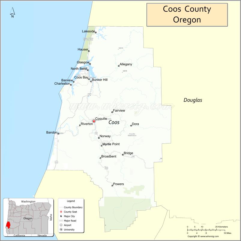
About Coos County Map, Oregon: The map showing the county boundary, county seat, major cities, highways, water bodies and neighbouring counties.
Oregon More Maps & Info
About Coos County, Oregon
Coos County is a county located in the U.S. state of Oregon. It's county seat is Coquille. As per 2020 census, the population of Coos County is 64999 people and population density is square miles. According to the United States Census Bureau, the county has a total area of 1,600 sq mi (4,144 km2). Coos County was established on 1853.
Coos County Facts
| Continent | North America |
| Country | United States |
| State | Oregon |
| County Seat | Coquille |
| Largest City/Town | Coos Bay |
| Established | 1853 |
| Total Area | 1,806 sq mi (4,678 sq km) |
| Land Area | 1,596 sq mi (4,134 sq km) |
| Water Area | 210 sq mi (544 sq km) |
| Population | 64,929 (Census 2020) |
| Population Density | 40.7 people per sq mi |
| Time Zone | Pacific Time Zone |
| Major Highways | U.S. Route 101, Oregon Route 42, Oregon Route 42S |
| Major Rivers | Coquille River, Coos River, South Fork Coos River, Millicoma River |
| Neighboring Counties | Douglas County, Curry County |
| Famous For | Pacific coastline, sand dunes, timber history, fishing, and outdoor recreation |
| Top Attractions | Oregon Dunes National Recreation Area, Shore Acres State Park, Cape Arago, Coos Bay Boardwalk, Bandon Beach |
| Official Website | Official Website |
About Coos County, Oregon
Coos County is located along the southern Oregon coast in the United States and was established in 1853. The county seat is Coquille, while Coos Bay is the largest city in the county. The county is known for rugged Pacific coastline, forested hills, coastal rivers, fishing communities, and large sand dune recreation areas.
Cities and Towns in Coos County, Oregon
| City/Town | Population (Census 2020) | Latitude & Longitude |
|---|---|---|
| Coquille (county seat) | 4,099 | 43.1771°N, 124.1876°W |
| Bandon | 3,398 | 43.1187°N, 124.4084°W |
| Coos Bay | 15,985 | 43.3665°N, 124.2179°W |
| Lakeside | 1,879 | 43.5815°N, 124.1751°W |
| Myrtle Point | 2,352 | 43.0648°N, 124.1390°W |
| North Bend | 10,078 | 43.4065°N, 124.2243°W |
| Powers | 689 | 42.8837°N, 124.0737°W |
| Barview (CDP) | 1,844 | 43.3547°N, 124.3301°W |
| Bunker Hill (CDP) | 1,777 | 43.3670°N, 124.2040°W |
| Charleston (CDP) | 819 | 43.3454°N, 124.3232°W |
| Glasgow (CDP) | 1,011 | 43.4291°N, 124.2193°W |
| Hauser (CDP) | 852 | 43.5211°N, 124.2145°W |
Golf Courses in Coos County, Oregon
| Golf Course | Location | Latitude & Longitude |
|---|---|---|
| Bandon Dunes Golf Resort | Bandon | 43.1892°N, 124.3902°W |
| Coos Golf Club | Coos Bay | 43.3514°N, 124.2479°W |
| Bandon Crossings Golf Course | Bandon | 43.1504°N, 124.3447°W |
| Bandon Face Rock Golf Course | Bandon | 43.1095°N, 124.4030°W |
| Forest Hills Country Club | Reedsport | 43.7028°N, 124.0935°W |
Roads and Highways in Coos County, Oregon
Major highways connect the county to nearby regions and cities.
- U.S. Route 101 - runs along the Pacific Coast and connects Coos Bay, North Bend, Bandon, and coastal communities
- Oregon Route 42 - links Coos Bay with Roseburg and Interstate 5 in Douglas County
- Oregon Route 42S - provides an alternate inland route between Bandon and U.S. Route 101
Neighboring Counties of Coos County
- Douglas County (north and east)
- Curry County (south)
Top Attractions in Coos County, Oregon
The county features several attractions known for history, nature, and recreation.
- Oregon Dunes National Recreation Area - large coastal dune system popular for off-road vehicles and hiking
- Shore Acres State Park - scenic oceanfront park with gardens and dramatic cliff views
- Cape Arago State Park - coastal recreation area known for wildlife viewing and ocean scenery
- Bandon Beach - famous beach with sea stacks and scenic sunset views
- Coos Bay Boardwalk - waterfront area with shops, restaurants, and marina views
- South Slough National Estuarine Research Reserve - protected estuary with trails and educational exhibits
- Face Rock State Scenic Viewpoint - coastal viewpoint featuring rock formations and beaches
- Golden and Silver Falls State Natural Area - waterfall destination within forested canyon landscapes
Distance from Coos County to Nearby Cities
The following distances are measured by road (driving).
- Coquille to Coos Bay (Coos County), Oregon - 16 mi (26 km)
- Coquille to North Bend (Coos County), Oregon - 20 mi (32 km)
- Coquille to Bandon (Coos County), Oregon - 14 mi (23 km)
- Coquille to Roseburg (Douglas County), Oregon - 73 mi (117 km)
- Coquille to Eugene (Lane County), Oregon - 126 mi (203 km)
- Coquille to Grants Pass (Josephine County), Oregon - 109 mi (175 km)
- Coquille to Medford (Jackson County), Oregon - 146 mi (235 km)
- Coquille to Newport (Lincoln County), Oregon - 115 mi (185 km)
- Coquille to Salem (Marion County), Oregon - 176 mi (283 km)
- Coquille to Portland (Multnomah County), Oregon - 246 mi (396 km)
- Coquille to Brookings (Curry County), Oregon - 98 mi (158 km)
- Coquille to Bend (Deschutes County), Oregon - 232 mi (373 km)
FAQs about Coos County
Coos County is located along the southern Oregon coast beside the Pacific Ocean.
Coos County had a population of 64,929 according to Census 2020 data.
Coos County is known for Pacific coastline scenery, sand dunes, fishing communities, timber history, and outdoor recreation.
The county is served by U.S. Route 101, Oregon Route 42, and Oregon Route 42S.
Yes, Coos County has several golf facilities including Bandon Dunes Golf Resort and Coos Golf Club.
- Baker County Map
- Benton County Map
- Clackamas County Map
- Clatsop County Map
- Columbia County Map
- Coos County Map
- Crook County Map
- Curry County Map
- Deschutes County Map
- Douglas County Map
- Gilliam County Map
- Grant County Map
- Harney County Map
- Hood River County Map
- Jackson County Map
- Jefferson County Map
- Josephine County Map
- Klamath County Map
- Lake County Map
- Lane County Map
- Lincoln County Map
- Linn County Map
- Malheur County Map
- Marion County Map
- Morrow County Map
- Multnomah County Map
- Polk County Map
- Sherman County Map
- Tillamook County Map
- Umatilla County Map
- Union County Map
- Wallowa County Map
- Wasco County Map
- Washington County Map
- Wheeler County Map
- Yamhill County Map
- Alabama Counties
- Alaska boroughs
- Arizona Counties
- Arkansas Counties
- California County Map
- Colorado Counties
- Connecticut Counties
- Delaware Counties
- Florida County Map
- Georgia County Map
- Hawaii Counties
- Idaho Counties
- Illinois Counties
- Indiana Counties
- Iowa Counties
- Kansas Counties
- Kentucky Counties
- Louisiana Counties
- Maine Counties
- Maryland Counties
- Massachusetts Counties
- Michigan County Map
- Minnesota Counties
- Mississippi Counties
- Missouri Counties
- Montana Counties
- Nebraska Counties
- Nevada Counties
- New York Counties
- New Hampshire Counties
- New Jersey Counties
- New Mexico Counties
- North Carolina Counties
- North Dakota Counties
- Ohio County Map
- Oklahoma Counties
- Oregon Counties
- Pennsylvania Counties
- Rhode Island Counties
- South Carolina Counties
- South Dakota Counties
- Map of Tennessee
- Texas County Map
- Utah Counties
- Vermont Counties
- Virginia Counties
- Washington Counties
- West Virginia Counties
- Wisconsin Counties
- Wyoming Counties