Map of Klamath County - Klamath County is a county located in the U.S. state of Oregon. Klamath County Map showing cities, highways, important places and water bodies. Get Where is Klamath County located in the map, major cities in Klamath county, population, areas, and places of interest.
Map of Klamath County, Oregon
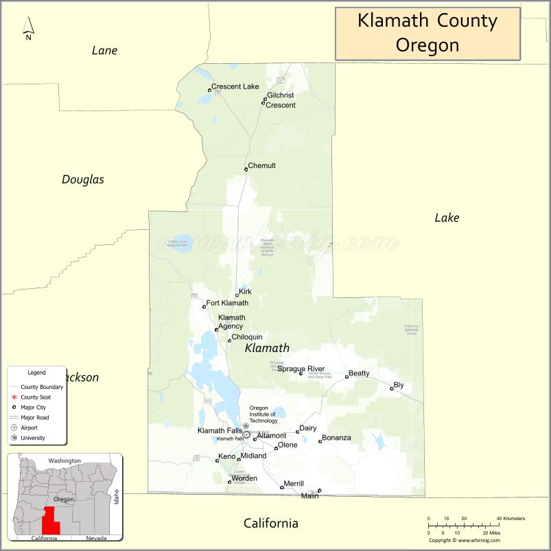
About Klamath County Map, Oregon: The map showing the county boundary, county seat, major cities, highways, water bodies and neighbouring counties.
Oregon More Maps & Info
About Klamath County, Oregon
Klamath County is a county located in the U.S. state of Oregon. It's county seat is Klamath Falls. As per 2020 census, the population of Klamath County is 70164 people and population density is square miles. According to the United States Census Bureau, the county has a total area of 5,945 sq mi (15,397 km2). Klamath County was established on 1882.
Klamath County Facts
| Continent | North America |
| Country | United States |
| State | Oregon |
| County Seat | Klamath Falls |
| Largest City/Town | Klamath Falls |
| Established | 1882 |
| Total Area | 6,136 sq mi (15,892 sq km) |
| Land Area | 5,941 sq mi (15,387 sq km) |
| Water Area | 195 sq mi (505 sq km) |
| Population | 69,413 (Census 2020) |
| Population Density | 11.7 people per sq mi |
| Time Zone | Pacific Time Zone |
| Major Highways | U.S. Route 97, Oregon Route 140, Oregon Route 66, Oregon Route 62 |
| Major Rivers | Klamath River, Williamson River, Sprague River, Lost River |
| Neighboring Counties | Deschutes County, Lake County, Jackson County, Douglas County, Siskiyou County (CA), Modoc County (CA) |
| Famous For | Crater Lake access, wetlands, forests, outdoor recreation, and wildlife refuges |
| Top Attractions | Crater Lake National Park nearby access, Upper Klamath Lake, Lava Beds nearby access, Klamath Basin wildlife refuges |
| Official Website | Official Website |
About Klamath County, Oregon
Klamath County is located in southern Oregon in the United States and was established in 1882. The county seat and largest city is Klamath Falls. The county is known for mountain scenery, lakes, forests, volcanic landscapes, wildlife refuges, and outdoor recreation opportunities throughout the Klamath Basin region.
Cities and Towns in Klamath County, Oregon
| City/Town | Population (Census 2020) | Latitude & Longitude |
|---|---|---|
| Klamath Falls (county seat) | 21,813 | 42.2249°N, 121.7817°W |
| Bonanza | 415 | 42.1960°N, 121.4058°W |
| Chiloquin | 767 | 42.5779°N, 121.8667°W |
| Malin | 805 | 42.0140°N, 121.3981°W |
| Merrill | 855 | 42.0265°N, 121.6008°W |
| Bly | 956 | 42.3979°N, 121.0400°W |
| Beatty (CDP) | 706 | 42.4396°N, 121.2691°W |
| Crescent (CDP) | 531 | 43.4570°N, 121.6922°W |
| Fort Klamath (CDP) | 199 | 42.7027°N, 121.9956°W |
| Gilchrist | 156 | 43.5276°N, 121.6884°W |
| Sprague River (CDP) | 514 | 42.4563°N, 121.5069°W |
Golf Courses in Klamath County, Oregon
| Golf Course | Location | Latitude & Longitude |
|---|---|---|
| Running Y Ranch Resort Golf Course | Klamath Falls | 42.1681°N, 121.8758°W |
| Shield Crest Golf Course | Klamath Falls | 42.2235°N, 121.7604°W |
| Harbor Links Golf Course | Klamath Falls | 42.2298°N, 121.7894°W |
| Arnold Palmer Course at Running Y | Klamath Falls | 42.1689°N, 121.8763°W |
Roads and Highways in Klamath County, Oregon
Major highways connect the county to nearby regions and cities.
- U.S. Route 97 - major north-south highway connecting Klamath Falls with Bend and northern California
- Oregon Route 140 - links Klamath Falls with Medford and southern Oregon mountain regions
- Oregon Route 66 - scenic route connecting the county with Ashland and the Rogue Valley
- Oregon Route 62 - provides access toward Crater Lake National Park and central Oregon
Neighboring Counties of Klamath County
- Deschutes County (north)
- Lake County (east)
- Jackson County (west)
- Douglas County (northwest)
- Siskiyou County, California (southwest)
- Modoc County, California (south)
Top Attractions in Klamath County, Oregon
The county features several attractions known for history, nature, and recreation.
- Crater Lake National Park nearby access - gateway route to Oregon's famous volcanic lake
- Upper Klamath Lake - large freshwater lake popular for boating, fishing, and birdwatching
- Klamath Basin National Wildlife Refuges - internationally important wetlands for migratory birds
- Running Y Ranch Resort - recreation destination with golf, trails, and mountain scenery
- Lava Beds National Monument nearby access - volcanic cave and lava flow area near the California border
- Moore Park - scenic park overlooking Upper Klamath Lake with hiking and recreation areas
- Collier Memorial State Park - museum and campground featuring logging history exhibits
- Williamson River - fishing and kayaking destination with scenic wetlands
Distance from Klamath County to Nearby Cities
The following distances are measured by road (driving).
- Klamath Falls to Medford (Jackson County), Oregon - 78 mi (126 km)
- Klamath Falls to Bend (Deschutes County), Oregon - 138 mi (222 km)
- Klamath Falls to Lakeview (Lake County), Oregon - 96 mi (154 km)
- Klamath Falls to Eugene (Lane County), Oregon - 174 mi (280 km)
- Klamath Falls to Redding (Shasta County), California - 142 mi (229 km)
- Klamath Falls to Ashland (Jackson County), Oregon - 66 mi (106 km)
- Klamath Falls to Roseburg (Douglas County), Oregon - 146 mi (235 km)
- Klamath Falls to Burns (Harney County), Oregon - 230 mi (370 km)
- Klamath Falls to Salem (Marion County), Oregon - 245 mi (394 km)
- Klamath Falls to Portland (Multnomah County), Oregon - 282 mi (454 km)
- Klamath Falls to Reno (Washoe County), Nevada - 273 mi (439 km)
- Klamath Falls to Sacramento (Sacramento County), California - 288 mi (463 km)
FAQs about Klamath County
Klamath County is located in southern Oregon near the California border.
Klamath County had a population of 69,413 according to Census 2020 data.
Klamath County is known for Crater Lake access, wetlands, wildlife refuges, forests, and outdoor recreation.
The county is served by U.S. Route 97, Oregon Route 140, Oregon Route 66, and Oregon Route 62.
Yes, Klamath County has several golf facilities including Running Y Ranch Resort Golf Course and Harbor Links Golf Course.
- Baker County Map
- Benton County Map
- Clackamas County Map
- Clatsop County Map
- Columbia County Map
- Coos County Map
- Crook County Map
- Curry County Map
- Deschutes County Map
- Douglas County Map
- Gilliam County Map
- Grant County Map
- Harney County Map
- Hood River County Map
- Jackson County Map
- Jefferson County Map
- Josephine County Map
- Klamath County Map
- Lake County Map
- Lane County Map
- Lincoln County Map
- Linn County Map
- Malheur County Map
- Marion County Map
- Morrow County Map
- Multnomah County Map
- Polk County Map
- Sherman County Map
- Tillamook County Map
- Umatilla County Map
- Union County Map
- Wallowa County Map
- Wasco County Map
- Washington County Map
- Wheeler County Map
- Yamhill County Map
- Alabama Counties
- Alaska boroughs
- Arizona Counties
- Arkansas Counties
- California County Map
- Colorado Counties
- Connecticut Counties
- Delaware Counties
- Florida County Map
- Georgia County Map
- Hawaii Counties
- Idaho Counties
- Illinois Counties
- Indiana Counties
- Iowa Counties
- Kansas Counties
- Kentucky Counties
- Louisiana Counties
- Maine Counties
- Maryland Counties
- Massachusetts Counties
- Michigan County Map
- Minnesota Counties
- Mississippi Counties
- Missouri Counties
- Montana Counties
- Nebraska Counties
- Nevada Counties
- New York Counties
- New Hampshire Counties
- New Jersey Counties
- New Mexico Counties
- North Carolina Counties
- North Dakota Counties
- Ohio County Map
- Oklahoma Counties
- Oregon Counties
- Pennsylvania Counties
- Rhode Island Counties
- South Carolina Counties
- South Dakota Counties
- Map of Tennessee
- Texas County Map
- Utah Counties
- Vermont Counties
- Virginia Counties
- Washington Counties
- West Virginia Counties
- Wisconsin Counties
- Wyoming Counties