Map of Malheur County - Malheur County is a county located in the U.S. state of Oregon. Malheur County Map showing cities, highways, important places and water bodies. Get Where is Malheur County located in the map, major cities in Malheur county, population, areas, and places of interest.
Map of Malheur County, Oregon
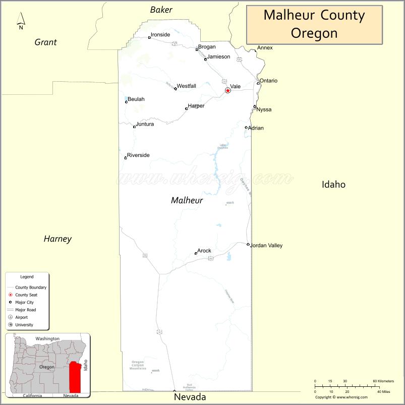
About Malheur County Map, Oregon: The map showing the county boundary, county seat, major cities, highways, water bodies and neighbouring counties.
Oregon More Maps & Info
About Malheur County, Oregon
Malheur County is a county located in the U.S. state of Oregon. It's county seat is Vale. As per 2020 census, the population of Malheur County is 31693 people and population density is square miles. According to the United States Census Bureau, the county has a total area of 9,888 sq mi (25,610 km2). Malheur County was established on 1887.
Malheur County Facts
| Continent | North America |
| Country | United States |
| State | Oregon |
| County Seat | Vale |
| Largest City/Town | Ontario |
| Established | 1887 |
| Total Area | 9,930 sq mi (25,719 sq km) |
| Land Area | 9,888 sq mi (25,610 sq km) |
| Water Area | 42 sq mi (109 sq km) |
| Population | 31,571 (Census 2020) |
| Population Density | 3.2 people per sq mi |
| Time Zone | Mountain Time Zone (most areas) |
| Major Highways | Interstate 84, U.S. Route 20, U.S. Route 26, U.S. Route 95 |
| Major Rivers | Snake River, Malheur River, Owyhee River |
| Neighboring Counties | Baker County, Grant County, Harney County, Canyon County (ID), Payette County (ID), Owyhee County (ID) |
| Famous For | Snake River agriculture, high desert landscapes, ranching, and the Owyhee Canyonlands |
| Top Attractions | Owyhee Canyonlands, Snake River, Four Rivers Cultural Center, Leslie Gulch, Lake Owyhee State Park |
| Official Website | Official Website |
About Malheur County, Oregon
Malheur County is located in southeastern Oregon in the United States and was established in 1887. The county seat is Vale, while Ontario is the largest city in the county. The county is known for high desert scenery, irrigated farmland, ranching communities, dramatic canyon landscapes, and outdoor recreation areas near the Idaho border.
Cities and Towns in Malheur County, Oregon
| City/Town | Population (Census 2020) | Latitude & Longitude |
|---|---|---|
| Vale (county seat) | 1,874 | 43.9821°N, 117.2385°W |
| Ontario | 11,645 | 44.0266°N, 116.9629°W |
| Adrian | 177 | 43.7390°N, 117.0721°W |
| Jordan Valley | 181 | 42.9743°N, 117.0542°W |
| Nyssa | 3,243 | 43.8782°N, 116.9943°W |
| Brogan | 90 | 44.2188°N, 117.4740°W |
| Harper | 109 | 43.8610°N, 117.6037°W |
| Juntura | 53 | 43.7485°N, 118.0549°W |
| Riverside | 19 | 43.5388°N, 118.1856°W |
Golf Courses in Malheur County, Oregon
| Golf Course | Location | Latitude & Longitude |
|---|---|---|
| Country View Golf Course | Ontario | 44.0328°N, 116.9512°W |
| Vale Golf Club | Vale | 43.9794°N, 117.2316°W |
| Nyssa Municipal Golf Course | Nyssa | 43.8796°N, 116.9860°W |
Roads and Highways in Malheur County, Oregon
Major highways connect the county to nearby regions and cities.
- Interstate 84 - major east-west highway connecting Ontario and Vale with Boise and western Oregon
- U.S. Route 20 - scenic route linking eastern Oregon communities with central Oregon and Idaho
- U.S. Route 26 - highway connecting Vale with John Day and western Oregon regions
- U.S. Route 95 - north-south route connecting southeastern Oregon with Nevada and Idaho
Neighboring Counties of Malheur County
- Baker County (north)
- Grant County (northwest)
- Harney County (west)
- Canyon County, Idaho (east)
- Payette County, Idaho (east)
- Owyhee County, Idaho (south and southeast)
Top Attractions in Malheur County, Oregon
The county features several attractions known for history, nature, and recreation.
- Owyhee Canyonlands - rugged canyon landscape known for hiking, rafting, and photography
- Lake Owyhee State Park - recreation area featuring boating, fishing, and camping
- Leslie Gulch - scenic volcanic canyon with dramatic rock formations
- Snake River - major river destination for boating and fishing
- Four Rivers Cultural Center - museum and cultural attraction in Ontario
- Succor Creek State Natural Area - remote desert recreation and camping destination
- Pillars of Rome - unique geological formations in southeastern Oregon
- Malheur Butte nearby views - volcanic landmark visible across the Snake River Plain
Distance from Malheur County to Nearby Cities
The following distances are measured by road (driving).
- Vale to Ontario (Malheur County), Oregon - 12 mi (19 km)
- Ontario to Boise (Ada County), Idaho - 55 mi (89 km)
- Vale to Burns (Harney County), Oregon - 129 mi (208 km)
- Vale to Baker City (Baker County), Oregon - 74 mi (119 km)
- Vale to John Day (Grant County), Oregon - 202 mi (325 km)
- Ontario to Nampa (Canyon County), Idaho - 46 mi (74 km)
- Ontario to Twin Falls (Twin Falls County), Idaho - 127 mi (204 km)
- Vale to Bend (Deschutes County), Oregon - 253 mi (407 km)
- Vale to Portland (Multnomah County), Oregon - 360 mi (579 km)
- Ontario to Salt Lake City (Salt Lake County), Utah - 372 mi (599 km)
- Vale to Reno (Washoe County), Nevada - 335 mi (539 km)
- Ontario to Medford (Jackson County), Oregon - 290 mi (467 km)
FAQs about Malheur County
Malheur County is located in southeastern Oregon along the Idaho border.
Malheur County had a population of 31,571 according to Census 2020 data.
Malheur County is known for high desert landscapes, agriculture, ranching, and the scenic Owyhee Canyonlands.
The county is served by Interstate 84, U.S. Route 20, U.S. Route 26, and U.S. Route 95.
Yes, Malheur County has golf facilities including Country View Golf Course and Vale Golf Club.
- Baker County Map
- Benton County Map
- Clackamas County Map
- Clatsop County Map
- Columbia County Map
- Coos County Map
- Crook County Map
- Curry County Map
- Deschutes County Map
- Douglas County Map
- Gilliam County Map
- Grant County Map
- Harney County Map
- Hood River County Map
- Jackson County Map
- Jefferson County Map
- Josephine County Map
- Klamath County Map
- Lake County Map
- Lane County Map
- Lincoln County Map
- Linn County Map
- Malheur County Map
- Marion County Map
- Morrow County Map
- Multnomah County Map
- Polk County Map
- Sherman County Map
- Tillamook County Map
- Umatilla County Map
- Union County Map
- Wallowa County Map
- Wasco County Map
- Washington County Map
- Wheeler County Map
- Yamhill County Map
- Alabama Counties
- Alaska boroughs
- Arizona Counties
- Arkansas Counties
- California County Map
- Colorado Counties
- Connecticut Counties
- Delaware Counties
- Florida County Map
- Georgia County Map
- Hawaii Counties
- Idaho Counties
- Illinois Counties
- Indiana Counties
- Iowa Counties
- Kansas Counties
- Kentucky Counties
- Louisiana Counties
- Maine Counties
- Maryland Counties
- Massachusetts Counties
- Michigan County Map
- Minnesota Counties
- Mississippi Counties
- Missouri Counties
- Montana Counties
- Nebraska Counties
- Nevada Counties
- New York Counties
- New Hampshire Counties
- New Jersey Counties
- New Mexico Counties
- North Carolina Counties
- North Dakota Counties
- Ohio County Map
- Oklahoma Counties
- Oregon Counties
- Pennsylvania Counties
- Rhode Island Counties
- South Carolina Counties
- South Dakota Counties
- Map of Tennessee
- Texas County Map
- Utah Counties
- Vermont Counties
- Virginia Counties
- Washington Counties
- West Virginia Counties
- Wisconsin Counties
- Wyoming Counties