Map of Wasco County - Wasco County is a county located in the U.S. state of Oregon. Wasco County Map showing cities, highways, important places and water bodies. Get Where is Wasco County located in the map, major cities in Wasco county, population, areas, and places of interest.
Map of Wasco County, Oregon
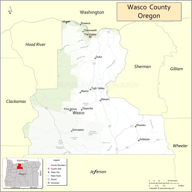
About Wasco County Map, Oregon: The map showing the county boundary, county seat, major cities, highways, water bodies and neighbouring counties.
Oregon More Maps & Info
About Wasco County, Oregon
Wasco County is a county located in the U.S. state of Oregon. It's county seat is The Dalles. As per 2020 census, the population of Wasco County is 26726 people and population density is square miles. According to the United States Census Bureau, the county has a total area of 2,381 sq mi (6,167 km2). Wasco County was established on 1854.
Wasco County Facts
| Continent | North America |
| Country | United States |
| State | Oregon |
| County Seat | The Dalles |
| Largest City/Town | The Dalles |
| Established | 1854 |
| Total Area | 2,395 sq mi (6,203 sq km) |
| Land Area | 2,382 sq mi (6,169 sq km) |
| Water Area | 13 sq mi (34 sq km) |
| Population | 26,131 (Census 2020) |
| Population Density | 11.0 people per sq mi |
| Time Zone | Pacific Time Zone |
| Major Highways | Interstate 84, U.S. Route 197, U.S. Route 97, Oregon Route 216 |
| Major Rivers | Columbia River, Deschutes River, White River |
| Neighboring Counties | Hood River County, Sherman County, Jefferson County, Clackamas County, Klickitat County (WA) |
| Famous For | Columbia River Gorge, orchards, windsurfing, and Oregon Trail history |
| Top Attractions | Columbia River Gorge, The Dalles Dam, historic downtown The Dalles, Mount Hood nearby access |
| Official Website | Official Website |
About Wasco County, Oregon
Wasco County is located in north-central Oregon in the United States and was established in 1854. The county seat and largest city is The Dalles. The county is known for Columbia River Gorge scenery, orchards, farming, outdoor recreation, and historic sites connected to the Oregon Trail and early western settlement.
Cities and Towns in Wasco County, Oregon
| City/Town | Population (Census 2020) | Latitude & Longitude |
|---|---|---|
| The Dalles (county seat) | 15,412 | 45.5946°N, 121.1787°W |
| Antelope | 37 | 44.9107°N, 120.7198°W |
| Dufur | 604 | 45.4535°N, 121.1309°W |
| Maupin | 427 | 45.1751°N, 121.0804°W |
| Mosier | 448 | 45.6848°N, 121.3973°W |
| Shaniko | 26 | 45.0382°N, 120.7542°W |
| Tygh Valley | 224 | 45.2476°N, 121.1698°W |
| Pine Hollow | 380 | 45.1064°N, 121.0716°W |
Golf Courses in Wasco County, Oregon
| Golf Course | Location | Latitude & Longitude |
|---|---|---|
| The Dalles Country Club | The Dalles | 45.6021°N, 121.1678°W |
| Desert Canyon Golf Resort | Maupin Area | 45.1740°N, 121.0825°W |
| Pine Hollow Golf Course | Pine Hollow | 45.1080°N, 121.0657°W |
Roads and Highways in Wasco County, Oregon
Major highways connect the county to nearby regions and scenic destinations.
- Interstate 84 - major east-west highway following the Columbia River Gorge through The Dalles
- U.S. Route 197 - north-south route connecting The Dalles with central Oregon and Washington State
- U.S. Route 97 - regional highway serving southern county areas and central Oregon access
- Oregon Route 216 - scenic route connecting rural communities and recreation areas
Neighboring Counties of Wasco County
- Hood River County (west)
- Clackamas County (west)
- Sherman County (east)
- Jefferson County (south)
- Klickitat County, Washington (north)
Top Attractions in Wasco County, Oregon
The county features several attractions known for scenery, recreation, and history.
- Columbia River Gorge - scenic canyon destination known for waterfalls, hiking, and river recreation
- The Dalles Dam - major hydroelectric facility along the Columbia River
- Mount Hood nearby access - mountain recreation destination for skiing and hiking
- Fort Dalles Museum - historic military and pioneer museum in The Dalles
- Deschutes River Recreation Area - rafting, fishing, and camping destination
- Maryhill Museum nearby access - regional art and history museum across the Columbia River
- Historic Downtown The Dalles - preserved architecture, murals, and local history attractions
- Shaniko Ghost Town - historic wool and railroad town with Old West character
Distance from Wasco County to Nearby Cities
The following distances are measured by road (driving).
- The Dalles to Hood River (Hood River County), Oregon - 21 mi (34 km)
- The Dalles to Portland (Multnomah County), Oregon - 83 mi (134 km)
- The Dalles to Bend (Deschutes County), Oregon - 121 mi (195 km)
- The Dalles to Salem (Marion County), Oregon - 116 mi (187 km)
- The Dalles to Pendleton (Umatilla County), Oregon - 117 mi (188 km)
- The Dalles to Madras (Jefferson County), Oregon - 67 mi (108 km)
- The Dalles to Astoria (Clatsop County), Oregon - 180 mi (290 km)
- The Dalles to Eugene (Lane County), Oregon - 170 mi (274 km)
- The Dalles to Hermiston (Umatilla County), Oregon - 97 mi (156 km)
- The Dalles to Seattle (King County), Washington - 228 mi (367 km)
- The Dalles to Medford (Jackson County), Oregon - 287 mi (462 km)
- The Dalles to Boise (Ada County), Idaho - 349 mi (562 km)
FAQs about Wasco County
Wasco County is located in north-central Oregon along the Columbia River Gorge.
Wasco County had a population of 26,131 according to Census 2020 data.
Wasco County is known for Columbia River Gorge scenery, orchards, outdoor recreation, and Oregon Trail history.
The county is served by Interstate 84, U.S. Route 197, U.S. Route 97, and Oregon Route 216.
Yes, Wasco County has golf facilities including The Dalles Country Club and Pine Hollow Golf Course.
- Baker County Map
- Benton County Map
- Clackamas County Map
- Clatsop County Map
- Columbia County Map
- Coos County Map
- Crook County Map
- Curry County Map
- Deschutes County Map
- Douglas County Map
- Gilliam County Map
- Grant County Map
- Harney County Map
- Hood River County Map
- Jackson County Map
- Jefferson County Map
- Josephine County Map
- Klamath County Map
- Lake County Map
- Lane County Map
- Lincoln County Map
- Linn County Map
- Malheur County Map
- Marion County Map
- Morrow County Map
- Multnomah County Map
- Polk County Map
- Sherman County Map
- Tillamook County Map
- Umatilla County Map
- Union County Map
- Wallowa County Map
- Wasco County Map
- Washington County Map
- Wheeler County Map
- Yamhill County Map
- Alabama Counties
- Alaska boroughs
- Arizona Counties
- Arkansas Counties
- California County Map
- Colorado Counties
- Connecticut Counties
- Delaware Counties
- Florida County Map
- Georgia County Map
- Hawaii Counties
- Idaho Counties
- Illinois Counties
- Indiana Counties
- Iowa Counties
- Kansas Counties
- Kentucky Counties
- Louisiana Counties
- Maine Counties
- Maryland Counties
- Massachusetts Counties
- Michigan County Map
- Minnesota Counties
- Mississippi Counties
- Missouri Counties
- Montana Counties
- Nebraska Counties
- Nevada Counties
- New York Counties
- New Hampshire Counties
- New Jersey Counties
- New Mexico Counties
- North Carolina Counties
- North Dakota Counties
- Ohio County Map
- Oklahoma Counties
- Oregon Counties
- Pennsylvania Counties
- Rhode Island Counties
- South Carolina Counties
- South Dakota Counties
- Map of Tennessee
- Texas County Map
- Utah Counties
- Vermont Counties
- Virginia Counties
- Washington Counties
- West Virginia Counties
- Wisconsin Counties
- Wyoming Counties