Map of Deschutes County - Deschutes County is a county located in the U.S. state of Oregon. Deschutes County Map showing cities, highways, important places and water bodies. Get Where is Deschutes County located in the map, major cities in Deschutes county, population, areas, and places of interest.
Map of Deschutes County, Oregon
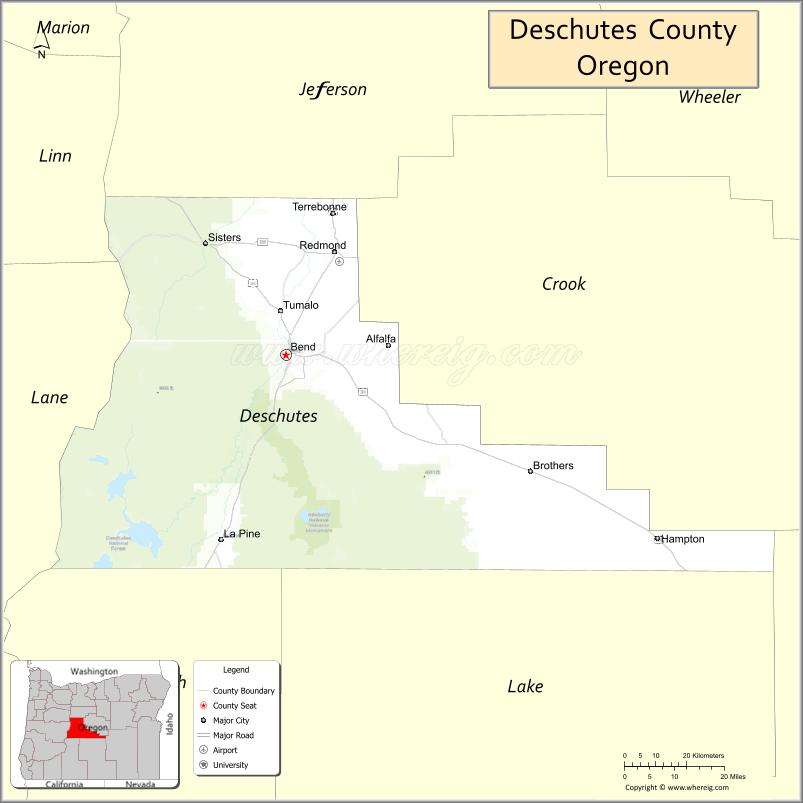
About Deschutes County Map, Oregon: The map showing the county boundary, county seat, major cities, highways, water bodies and neighbouring counties.
Oregon More Maps & Info
About Deschutes County, Oregon
Deschutes County is a county located in the U.S. state of Oregon. It's county seat is Bend. As per 2020 census, the population of Deschutes County is 204801 people and population density is square miles. According to the United States Census Bureau, the county has a total area of 3,018 sq mi (7,817 km2). Deschutes County was established on 1916.
Deschutes County Facts
| Continent | North America |
| Country | United States |
| State | Oregon |
| County Seat | Bend |
| Largest City/Town | Bend |
| Established | 1916 |
| Total Area | 3,055 sq mi (7,912 sq km) |
| Land Area | 3,018 sq mi (7,817 sq km) |
| Water Area | 37 sq mi (96 sq km) |
| Population | 198,253 (Census 2020) |
| Population Density | 65.7 people per sq mi |
| Time Zone | Pacific Time Zone |
| Major Highways | U.S. Route 20, U.S. Route 97, Oregon Route 126, Cascade Lakes Scenic Byway |
| Major Rivers | Deschutes River, Little Deschutes River, Crooked River |
| Neighboring Counties | Jefferson County, Crook County, Klamath County, Lake County, Linn County, Lane County |
| Famous For | Outdoor recreation, skiing, volcanic landscapes, breweries, and scenic mountain views |
| Top Attractions | Mount Bachelor, Smith Rock State Park nearby access, Deschutes River, Newberry National Volcanic Monument, High Desert Museum |
| Official Website | Official Website |
About Deschutes County, Oregon
Deschutes County is located in central Oregon in the United States and was established in 1916. The county seat is Bend, which is also the largest city in the county. The county is known for its high desert climate, volcanic landscapes, Cascade Mountain views, rivers, forests, and year-round outdoor recreation opportunities.
Cities and Towns in Deschutes County, Oregon
| City/Town | Population (Census 2020) | Latitude & Longitude |
|---|---|---|
| Bend (county seat) | 99,178 | 44.0582°N, 121.3153°W |
| La Pine | 2,512 | 43.6707°N, 121.5036°W |
| Redmond | 33,274 | 44.2726°N, 121.1739°W |
| Sisters | 3,104 | 44.2909°N, 121.5492°W |
| Sunriver (CDP) | 1,393 | 43.8768°N, 121.4381°W |
| Terrebonne (CDP) | 1,304 | 44.3532°N, 121.1767°W |
| Tumalo (CDP) | 668 | 44.1510°N, 121.3306°W |
| Eagle Crest (CDP) | 1,386 | 44.2774°N, 121.2651°W |
| Black Butte Ranch (CDP) | 1,107 | 44.3398°N, 121.6462°W |
Golf Courses in Deschutes County, Oregon
| Golf Course | Location | Latitude & Longitude |
|---|---|---|
| Tetherow Golf Club | Bend | 44.0345°N, 121.3568°W |
| Broken Top Club | Bend | 44.0342°N, 121.3479°W |
| Widgi Creek Golf Club | Bend | 44.0228°N, 121.3674°W |
| Pronghorn Club | Bend | 44.0925°N, 121.0804°W |
| Sunriver Resort Golf Courses | Sunriver | 43.8851°N, 121.4387°W |
| Crosswater Club | Sunriver | 43.8658°N, 121.4456°W |
| Aspen Lakes Golf Course | Sisters | 44.3189°N, 121.5793°W |
| Black Butte Ranch Golf Courses | Black Butte Ranch | 44.3371°N, 121.6470°W |
| Eagle Crest Resort Golf Courses | Redmond | 44.2729°N, 121.2648°W |
| Juniper Golf Course | Redmond | 44.2638°N, 121.1864°W |
| Lost Tracks Golf Club | Bend | 44.0330°N, 121.2774°W |
| River's Edge Golf Course | Bend | 44.0738°N, 121.3282°W |
Roads and Highways in Deschutes County, Oregon
Major highways connect the county to nearby regions and cities.
- U.S. Route 97 - major north-south highway connecting Bend, Redmond, and La Pine with central Oregon communities
- U.S. Route 20 - east-west route linking Sisters, Bend, and eastern Oregon regions
- Oregon Route 126 - connects Sisters and western mountain communities with Eugene
- Cascade Lakes Scenic Byway - scenic route providing access to lakes, forests, and recreation areas near Mount Bachelor
Neighboring Counties of Deschutes County
- Jefferson County (north)
- Crook County (east)
- Lake County (southeast)
- Klamath County (south)
- Lane County (west)
- Linn County (northwest)
Top Attractions in Deschutes County, Oregon
The county features several attractions known for history, nature, and recreation.
- Mount Bachelor - major skiing and snowboarding destination in the Cascade Range
- Newberry National Volcanic Monument - volcanic landscape featuring lava flows, lakes, and hiking trails
- Deschutes River Trail - scenic riverfront trail system popular for walking and biking
- High Desert Museum - museum showcasing regional wildlife, history, and Native American culture
- Smith Rock State Park nearby access - internationally recognized rock climbing and hiking area
- Sparks Lake - scenic mountain lake known for kayaking and photography
- Tumalo Falls - waterfall destination with hiking opportunities in national forest land
- Old Mill District - shopping, dining, and entertainment area along the Deschutes River in Bend
Distance from Deschutes County to Nearby Cities
The following distances are measured by road (driving).
- Bend to Redmond (Deschutes County), Oregon - 16 mi (26 km)
- Bend to Sisters (Deschutes County), Oregon - 22 mi (35 km)
- Bend to Prineville (Crook County), Oregon - 36 mi (58 km)
- Bend to Madras (Jefferson County), Oregon - 44 mi (71 km)
- Bend to Eugene (Lane County), Oregon - 128 mi (206 km)
- Bend to Salem (Marion County), Oregon - 135 mi (217 km)
- Bend to Portland (Multnomah County), Oregon - 162 mi (261 km)
- Bend to Medford (Jackson County), Oregon - 176 mi (283 km)
- Bend to Klamath Falls (Klamath County), Oregon - 138 mi (222 km)
- Bend to Newport (Lincoln County), Oregon - 178 mi (286 km)
- Bend to Pendleton (Umatilla County), Oregon - 216 mi (348 km)
- Bend to Burns (Harney County), Oregon - 129 mi (208 km)
FAQs about Deschutes County
Deschutes County is located in central Oregon within the high desert region east of the Cascade Mountains.
Deschutes County had a population of 198,253 according to Census 2020 data.
Deschutes County is known for outdoor recreation, skiing, volcanic scenery, breweries, and mountain landscapes.
The county is served by U.S. Route 97, U.S. Route 20, Oregon Route 126, and the Cascade Lakes Scenic Byway.
Yes, Deschutes County has many golf facilities including Tetherow Golf Club, Sunriver Resort Golf Courses, and Pronghorn Club.
- Baker County Map
- Benton County Map
- Clackamas County Map
- Clatsop County Map
- Columbia County Map
- Coos County Map
- Crook County Map
- Curry County Map
- Deschutes County Map
- Douglas County Map
- Gilliam County Map
- Grant County Map
- Harney County Map
- Hood River County Map
- Jackson County Map
- Jefferson County Map
- Josephine County Map
- Klamath County Map
- Lake County Map
- Lane County Map
- Lincoln County Map
- Linn County Map
- Malheur County Map
- Marion County Map
- Morrow County Map
- Multnomah County Map
- Polk County Map
- Sherman County Map
- Tillamook County Map
- Umatilla County Map
- Union County Map
- Wallowa County Map
- Wasco County Map
- Washington County Map
- Wheeler County Map
- Yamhill County Map
- Alabama Counties
- Alaska boroughs
- Arizona Counties
- Arkansas Counties
- California County Map
- Colorado Counties
- Connecticut Counties
- Delaware Counties
- Florida County Map
- Georgia County Map
- Hawaii Counties
- Idaho Counties
- Illinois Counties
- Indiana Counties
- Iowa Counties
- Kansas Counties
- Kentucky Counties
- Louisiana Counties
- Maine Counties
- Maryland Counties
- Massachusetts Counties
- Michigan County Map
- Minnesota Counties
- Mississippi Counties
- Missouri Counties
- Montana Counties
- Nebraska Counties
- Nevada Counties
- New York Counties
- New Hampshire Counties
- New Jersey Counties
- New Mexico Counties
- North Carolina Counties
- North Dakota Counties
- Ohio County Map
- Oklahoma Counties
- Oregon Counties
- Pennsylvania Counties
- Rhode Island Counties
- South Carolina Counties
- South Dakota Counties
- Map of Tennessee
- Texas County Map
- Utah Counties
- Vermont Counties
- Virginia Counties
- Washington Counties
- West Virginia Counties
- Wisconsin Counties
- Wyoming Counties