Map of Benton County - Benton County is a county located in the U.S. state of Oregon. Benton County Map showing cities, highways, important places and water bodies. Get Where is Benton County located in the map, major cities in Benton county, population, areas, and places of interest.
Map of Benton County, Oregon
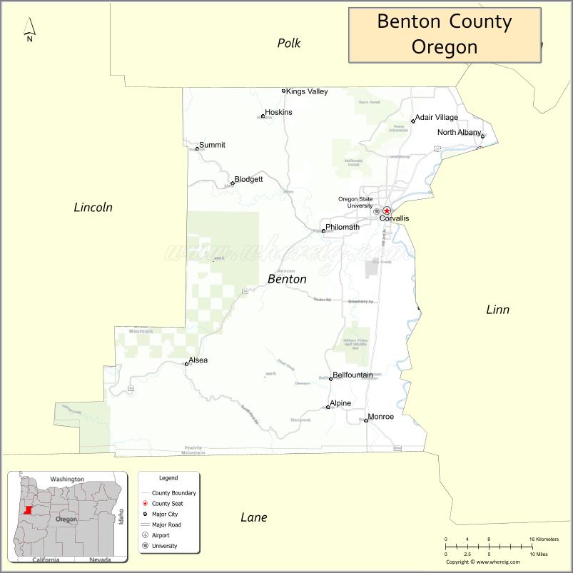
About Benton County Map, Oregon: The map showing the county boundary, county seat, major cities, highways, water bodies and neighbouring counties.
Oregon More Maps & Info
About Benton County, Oregon
Benton County is a county located in the U.S. state of Oregon. It's county seat is Corvallis. As per 2020 census, the population of Benton County is 96017 people and population density is square miles. According to the United States Census Bureau, the county has a total area of 676 sq mi (1,751 km2). Benton County was established on 1847.
Benton County Facts
| Continent | North America |
| Country | United States |
| State | Oregon |
| County Seat | Corvallis |
| Largest City/Town | Corvallis |
| Established | 1847 |
| Total Area | 679 sq mi (1,759 sq km) |
| Land Area | 676 sq mi (1,751 sq km) |
| Water Area | 3 sq mi (8 sq km) |
| Population | 95,184 (Census 2020) |
| Population Density | 140.8 people per sq mi |
| Time Zone | Pacific Time Zone |
| Major Highways | U.S. Route 20, Oregon Route 34, Oregon Route 99W |
| Major Rivers | Willamette River, Marys River, Alsea River |
| Neighboring Counties | Lincoln County, Polk County, Linn County, Lane County |
| Famous For | Oregon State University, agriculture, wineries, and natural scenery |
| Top Attractions | Oregon State University, William L. Finley National Wildlife Refuge, Bald Hill Natural Area, Peavy Arboretum |
| Official Website | Official Website |
About Benton County, Oregon
Benton County is located in the western part of Oregon in the United States and was established in 1847. The county seat is Corvallis, which is also the largest city in the county. The county is known for its fertile Willamette Valley farmland, forested hills, university community, and outdoor recreation areas.
Cities and Towns in Benton County, Oregon
| City/Town | Population (Census 2020) | Latitude & Longitude |
|---|---|---|
| Corvallis (county seat) | 59,922 | 44.5646°N, 123.2620°W |
| Adair Village | 840 | 44.6704°N, 123.2170°W |
| Monroe | 651 | 44.3146°N, 123.2962°W |
| Philomath | 5,666 | 44.5401°N, 123.3670°W |
| Albany (partly in Benton County) | 56,472 | 44.6365°N, 123.1059°W |
| Alpine (CDP) | 171 | 44.3285°N, 123.3584°W |
| Bellfountain (CDP) | 88 | 44.2804°N, 123.2337°W |
| Blodgett (CDP) | 58 | 44.5923°N, 123.5348°W |
| Lewisburg (CDP) | 372 | 44.6287°N, 123.2365°W |
| Summit (CDP) | 114 | 44.4260°N, 123.4675°W |
Golf Courses in Benton County, Oregon
| Golf Course | Location | Latitude & Longitude |
|---|---|---|
| Trysting Tree Golf Club | Corvallis | 44.5605°N, 123.2905°W |
| Spring Hill Country Club | Albany | 44.5975°N, 123.1256°W |
| Corvallis Country Club | Corvallis | 44.5856°N, 123.2433°W |
Roads and Highways in Benton County, Oregon
Major highways connect the county to nearby regions and cities.
- U.S. Route 20 - runs east-west through Corvallis and connects the county with Newport and Albany
- Oregon Route 34 - links Corvallis with Interstate 5 and the Oregon Coast
- Oregon Route 99W - connects Benton County with McMinnville, Monmouth, and Eugene areas
Neighboring Counties of Benton County
- Polk County (north)
- Linn County (east)
- Lane County (south)
- Lincoln County (west)
Top Attractions in Benton County, Oregon
The county features several attractions known for history, nature, and recreation.
- Oregon State University - major public university with museums, gardens, and sports venues
- William L. Finley National Wildlife Refuge - protected area known for birdwatching and wetlands
- Bald Hill Natural Area - scenic hiking and biking destination near Corvallis
- Peavy Arboretum - forest research area with trails and educational exhibits
- Avery Park and Natural Area - popular community park with gardens and walking paths
- Marys Peak - highest point in Oregon's Coast Range with panoramic views
- Corvallis Farmers' Market - local market featuring regional produce and crafts
- Philomath Museum - local museum focused on pioneer and regional history
Distance from Benton County to Nearby Cities
The following distances are measured by road (driving).
- Corvallis to Albany (Linn County), Oregon - 11 mi (18 km)
- Corvallis to Salem (Marion County), Oregon - 39 mi (63 km)
- Corvallis to Eugene (Lane County), Oregon - 47 mi (76 km)
- Corvallis to Newport (Lincoln County), Oregon - 52 mi (84 km)
- Corvallis to Lebanon (Linn County), Oregon - 31 mi (50 km)
- Corvallis to Dallas (Polk County), Oregon - 28 mi (45 km)
- Corvallis to McMinnville (Yamhill County), Oregon - 47 mi (76 km)
- Corvallis to Portland (Multnomah County), Oregon - 86 mi (138 km)
- Corvallis to Lincoln City (Lincoln County), Oregon - 74 mi (119 km)
- Corvallis to Bend (Deschutes County), Oregon - 137 mi (220 km)
- Corvallis to Medford (Jackson County), Oregon - 175 mi (282 km)
- Corvallis to Astoria (Clatsop County), Oregon - 145 mi (233 km)
FAQs about Benton County
Benton County is located in western Oregon in the Willamette Valley region.
Benton County had a population of 95,184 according to Census 2020 data.
Benton County is known for Oregon State University, agriculture, wineries, and outdoor recreation areas.
The county is served by U.S. Route 20, Oregon Route 34, and Oregon Route 99W.
Yes, Benton County has several golf facilities including Trysting Tree Golf Club and Corvallis Country Club.
- Baker County Map
- Benton County Map
- Clackamas County Map
- Clatsop County Map
- Columbia County Map
- Coos County Map
- Crook County Map
- Curry County Map
- Deschutes County Map
- Douglas County Map
- Gilliam County Map
- Grant County Map
- Harney County Map
- Hood River County Map
- Jackson County Map
- Jefferson County Map
- Josephine County Map
- Klamath County Map
- Lake County Map
- Lane County Map
- Lincoln County Map
- Linn County Map
- Malheur County Map
- Marion County Map
- Morrow County Map
- Multnomah County Map
- Polk County Map
- Sherman County Map
- Tillamook County Map
- Umatilla County Map
- Union County Map
- Wallowa County Map
- Wasco County Map
- Washington County Map
- Wheeler County Map
- Yamhill County Map
- Alabama Counties
- Alaska boroughs
- Arizona Counties
- Arkansas Counties
- California County Map
- Colorado Counties
- Connecticut Counties
- Delaware Counties
- Florida County Map
- Georgia County Map
- Hawaii Counties
- Idaho Counties
- Illinois Counties
- Indiana Counties
- Iowa Counties
- Kansas Counties
- Kentucky Counties
- Louisiana Counties
- Maine Counties
- Maryland Counties
- Massachusetts Counties
- Michigan County Map
- Minnesota Counties
- Mississippi Counties
- Missouri Counties
- Montana Counties
- Nebraska Counties
- Nevada Counties
- New York Counties
- New Hampshire Counties
- New Jersey Counties
- New Mexico Counties
- North Carolina Counties
- North Dakota Counties
- Ohio County Map
- Oklahoma Counties
- Oregon Counties
- Pennsylvania Counties
- Rhode Island Counties
- South Carolina Counties
- South Dakota Counties
- Map of Tennessee
- Texas County Map
- Utah Counties
- Vermont Counties
- Virginia Counties
- Washington Counties
- West Virginia Counties
- Wisconsin Counties
- Wyoming Counties