Map of Grant County - Grant County is a county located in the U.S. state of Oregon. Grant County Map showing cities, highways, important places and water bodies. Get Where is Grant County located in the map, major cities in Grant county, population, areas, and places of interest.
Map of Grant County, Oregon
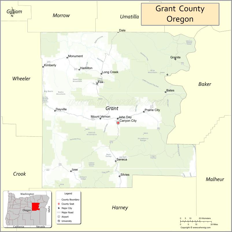
About Grant County Map, Oregon: The map showing the county boundary, county seat, major cities, highways, water bodies and neighbouring counties.
Oregon More Maps & Info
About Grant County, Oregon
Grant County is a county located in the U.S. state of Oregon. It's county seat is Canyon City. As per 2020 census, the population of Grant County is 7272 people and population density is square miles. According to the United States Census Bureau, the county has a total area of 4,529 sq mi (11,730 km2). Grant County was established on 1864.
Grant County Facts
| Continent | North America |
| Country | United States |
| State | Oregon |
| County Seat | Canyon City |
| Largest City/Town | John Day |
| Established | 1864 |
| Total Area | 4,529 sq mi (11,730 sq km) |
| Land Area | 4,507 sq mi (11,673 sq km) |
| Water Area | 22 sq mi (57 sq km) |
| Population | 7,233 (Census 2020) |
| Population Density | 1.6 people per sq mi |
| Time Zone | Pacific Time Zone |
| Major Highways | U.S. Route 26, U.S. Route 395, Oregon Route 19 |
| Major Rivers | John Day River, Middle Fork John Day River, North Fork John Day River |
| Neighboring Counties | Wheeler County, Crook County, Harney County, Malheur County, Baker County, Union County, Umatilla County |
| Famous For | John Day Fossil Beds, ranching, wilderness areas, and scenic mountain landscapes |
| Top Attractions | John Day Fossil Beds National Monument, Malheur National Forest, Strawberry Mountains, Kam Wah Chung State Heritage Site |
| Official Website | Official Website |
About Grant County, Oregon
Grant County is located in eastern Oregon in the United States and was established in 1864. The county seat is Canyon City, while John Day is the largest city in the county. The county is known for rugged mountain landscapes, forests, ranching communities, fossil sites, and wide-open wilderness areas popular for outdoor recreation.
Cities and Towns in Grant County, Oregon
| City/Town | Population (Census 2020) | Latitude & Longitude |
|---|---|---|
| Canyon City (county seat) | 703 | 44.3899°N, 118.9505°W |
| John Day | 1,664 | 44.4165°N, 118.9530°W |
| Dayville | 132 | 44.4668°N, 119.5333°W |
| Long Creek | 179 | 44.7101°N, 119.1019°W |
| Monument | 115 | 44.8182°N, 119.4200°W |
| Mount Vernon | 451 | 44.4199°N, 119.1188°W |
| Prairie City | 909 | 44.4635°N, 118.7080°W |
| Seneca | 199 | 44.1376°N, 118.9757°W |
| Granite | 38 | 44.8107°N, 118.4303°W |
| Kimberly (CDP) | 18 | 44.7610°N, 119.6472°W |
Golf Courses in Grant County, Oregon
| Golf Course | Location | Latitude & Longitude |
|---|---|---|
| John Day Golf Club | John Day | 44.4120°N, 118.9447°W |
| Prairie City Golf Course | Prairie City | 44.4630°N, 118.7114°W |
| Mountain View Golf Course | Seneca | 44.1389°N, 118.9782°W |
Roads and Highways in Grant County, Oregon
Major highways connect the county to nearby regions and cities.
- U.S. Route 26 - main east-west highway connecting John Day with Prineville, Baker City, and eastern Oregon communities
- U.S. Route 395 - north-south route linking Grant County with Pendleton and Burns
- Oregon Route 19 - scenic route connecting the county with the John Day River canyon region
Neighboring Counties of Grant County
- Umatilla County (north)
- Union County (northeast)
- Baker County (east)
- Malheur County (southeast)
- Harney County (south)
- Crook County (west)
- Wheeler County (northwest)
Top Attractions in Grant County, Oregon
The county features several attractions known for history, nature, and recreation.
- John Day Fossil Beds National Monument - famous fossil and colorful badlands landscape destination
- Malheur National Forest - large forest recreation area with camping, hiking, and fishing opportunities
- Strawberry Mountains - scenic mountain range popular for backpacking and wildlife viewing
- Kam Wah Chung State Heritage Site - preserved Chinese apothecary and museum in John Day
- Blue Basin Overlook - striking geological formation with hiking trails and panoramic views
- Clyde Holliday State Recreation Site - riverside camping and fishing area near John Day
- Grant County Historical Museum - museum focused on mining, ranching, and pioneer history
- John Day River - scenic river corridor popular for rafting and fishing
Distance from Grant County to Nearby Cities
The following distances are measured by road (driving).
- Canyon City to John Day (Grant County), Oregon - 1 mi (2 km)
- Canyon City to Burns (Harney County), Oregon - 131 mi (211 km)
- Canyon City to Baker City (Baker County), Oregon - 132 mi (212 km)
- Canyon City to Pendleton (Umatilla County), Oregon - 169 mi (272 km)
- Canyon City to Bend (Deschutes County), Oregon - 122 mi (196 km)
- Canyon City to Prineville (Crook County), Oregon - 122 mi (196 km)
- Canyon City to La Grande (Union County), Oregon - 132 mi (212 km)
- Canyon City to Ontario (Malheur County), Oregon - 202 mi (325 km)
- Canyon City to Salem (Marion County), Oregon - 256 mi (412 km)
- Canyon City to Portland (Multnomah County), Oregon - 268 mi (431 km)
- Canyon City to Boise (Ada County), Idaho - 256 mi (412 km)
- Canyon City to Eugene (Lane County), Oregon - 222 mi (357 km)
FAQs about Grant County
Grant County is located in eastern Oregon and is known for its mountain and wilderness landscapes.
Grant County had a population of 7,233 according to Census 2020 data.
Grant County is known for the John Day Fossil Beds, ranching, forests, and scenic outdoor recreation areas.
The county is served by U.S. Route 26, U.S. Route 395, and Oregon Route 19.
Yes, Grant County has golf facilities including John Day Golf Club and Prairie City Golf Course.
- Baker County Map
- Benton County Map
- Clackamas County Map
- Clatsop County Map
- Columbia County Map
- Coos County Map
- Crook County Map
- Curry County Map
- Deschutes County Map
- Douglas County Map
- Gilliam County Map
- Grant County Map
- Harney County Map
- Hood River County Map
- Jackson County Map
- Jefferson County Map
- Josephine County Map
- Klamath County Map
- Lake County Map
- Lane County Map
- Lincoln County Map
- Linn County Map
- Malheur County Map
- Marion County Map
- Morrow County Map
- Multnomah County Map
- Polk County Map
- Sherman County Map
- Tillamook County Map
- Umatilla County Map
- Union County Map
- Wallowa County Map
- Wasco County Map
- Washington County Map
- Wheeler County Map
- Yamhill County Map
- Alabama Counties
- Alaska boroughs
- Arizona Counties
- Arkansas Counties
- California County Map
- Colorado Counties
- Connecticut Counties
- Delaware Counties
- Florida County Map
- Georgia County Map
- Hawaii Counties
- Idaho Counties
- Illinois Counties
- Indiana Counties
- Iowa Counties
- Kansas Counties
- Kentucky Counties
- Louisiana Counties
- Maine Counties
- Maryland Counties
- Massachusetts Counties
- Michigan County Map
- Minnesota Counties
- Mississippi Counties
- Missouri Counties
- Montana Counties
- Nebraska Counties
- Nevada Counties
- New York Counties
- New Hampshire Counties
- New Jersey Counties
- New Mexico Counties
- North Carolina Counties
- North Dakota Counties
- Ohio County Map
- Oklahoma Counties
- Oregon Counties
- Pennsylvania Counties
- Rhode Island Counties
- South Carolina Counties
- South Dakota Counties
- Map of Tennessee
- Texas County Map
- Utah Counties
- Vermont Counties
- Virginia Counties
- Washington Counties
- West Virginia Counties
- Wisconsin Counties
- Wyoming Counties