Map of Harney County - Harney County is a county located in the U.S. state of Oregon. Harney County Map showing cities, highways, important places and water bodies. Get Where is Harney County located in the map, major cities in Harney county, population, areas, and places of interest.
Map of Harney County, Oregon
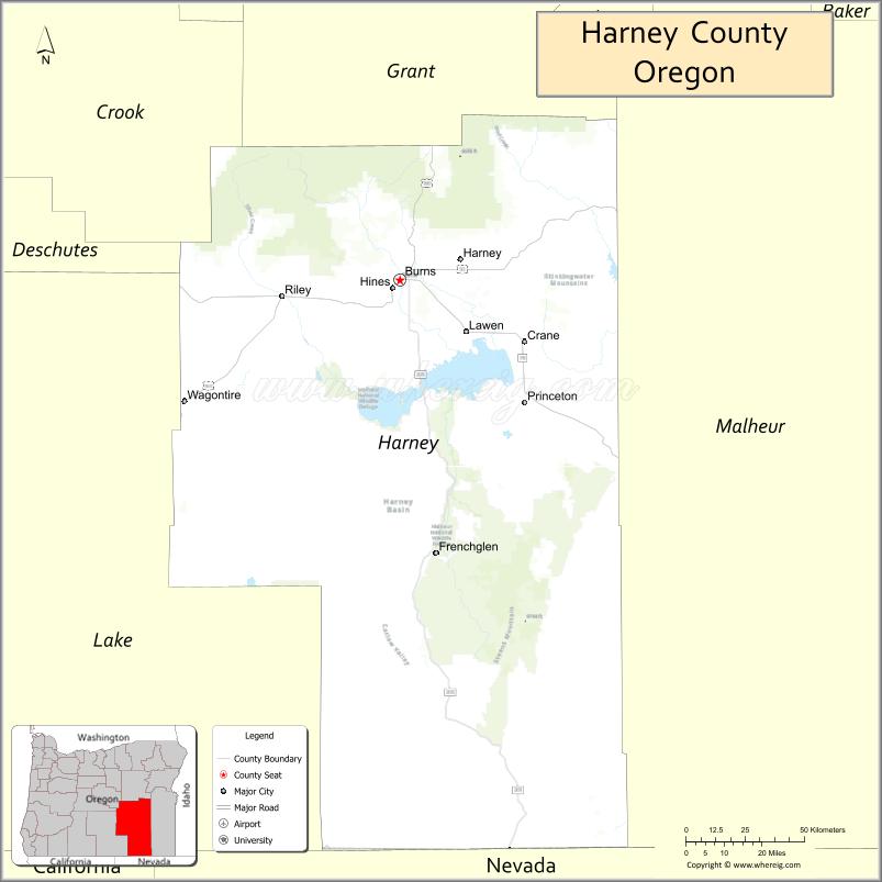
About Harney County Map, Oregon: The map showing the county boundary, county seat, major cities, highways, water bodies and neighbouring counties.
Oregon More Maps & Info
About Harney County, Oregon
Harney County is a county located in the U.S. state of Oregon. It's county seat is Burns. As per 2020 census, the population of Harney County is 7575 people and population density is square miles. According to the United States Census Bureau, the county has a total area of 10,135 sq mi (26,250 km2). Harney County was established on 1889.
Harney County Facts
| Continent | North America |
| Country | United States |
| State | Oregon |
| County Seat | Burns |
| Largest City/Town | Burns |
| Established | 1889 |
| Total Area | 10,226 sq mi (26,488 sq km) |
| Land Area | 10,133 sq mi (26,245 sq km) |
| Water Area | 93 sq mi (241 sq km) |
| Population | 7,495 (Census 2020) |
| Population Density | 0.7 people per sq mi |
| Time Zone | Pacific Time Zone |
| Major Highways | U.S. Route 20, U.S. Route 395, Oregon Route 78, Oregon Route 205 |
| Major Rivers | Silvies River, Donner und Blitzen River, Malheur River |
| Neighboring Counties | Grant County, Malheur County, Lake County, Crook County, Deschutes County |
| Famous For | High desert landscapes, ranching, wildlife refuges, birdwatching, and wide-open wilderness |
| Top Attractions | Malheur National Wildlife Refuge, Steens Mountain, Alvord Desert, Harney Basin, Pete French Round Barn |
| Official Website | Official Website |
About Harney County, Oregon
Harney County is located in southeastern Oregon in the United States and was established in 1889. The county seat is Burns, which is also the largest city in the county. Harney County is the largest county in Oregon by area and is known for its high desert terrain, mountain ranges, wildlife habitats, ranchlands, and remote natural landscapes.
Cities and Towns in Harney County, Oregon
| City/Town | Population (Census 2020) | Latitude & Longitude |
|---|---|---|
| Burns (county seat) | 2,730 | 43.5863°N, 119.0541°W |
| Hines | 1,553 | 43.5668°N, 119.0800°W |
| Crane | 127 | 43.4151°N, 118.5752°W |
| Diamond | 5 | 43.0718°N, 118.6077°W |
| Drewsey | Not Incorporated | 43.7902°N, 118.3630°W |
| Frenchglen | 12 | 42.8268°N, 118.9096°W |
| Princeton | Not Incorporated | 42.8608°N, 118.5009°W |
| Riley | 18 | 43.5365°N, 119.5395°W |
| Fields | 120 | 42.2640°N, 118.6763°W |
Golf Courses in Harney County, Oregon
| Golf Course | Location | Latitude & Longitude |
|---|---|---|
| Valley Golf Club | Hines | 43.5662°N, 119.0905°W |
| Burns Municipal Golf Course | Burns | 43.5921°N, 119.0684°W |
Roads and Highways in Harney County, Oregon
Major highways connect the county to nearby regions and cities.
- U.S. Route 20 - major east-west route connecting Burns with Bend, Ontario, and central Oregon communities
- U.S. Route 395 - north-south highway linking Harney County with John Day and Lakeview
- Oregon Route 78 - connects Burns with Crane and southeastern Oregon ranching areas
- Oregon Route 205 - scenic route leading toward Frenchglen, Steens Mountain, and the Alvord Desert region
Neighboring Counties of Harney County
- Grant County (north)
- Malheur County (east)
- Lake County (southwest)
- Crook County (northwest)
- Deschutes County (west)
Top Attractions in Harney County, Oregon
The county features several attractions known for history, nature, and recreation.
- Malheur National Wildlife Refuge - internationally recognized birdwatching and wildlife habitat area
- Steens Mountain - dramatic mountain landscape with scenic drives and hiking opportunities
- Alvord Desert - remote dry lakebed known for camping, photography, and wide-open scenery
- Pete French Round Barn - historic ranch structure and Oregon heritage site
- Harney Basin Wetlands - important migratory bird habitat and natural area
- Diamond Craters - volcanic field with lava formations and geological features
- Crystal Crane Hot Springs - natural hot springs resort near Burns
- Malheur Cave - lava tube cave formation in southeastern Oregon
Distance from Harney County to Nearby Cities
The following distances are measured by road (driving).
- Burns to John Day (Grant County), Oregon - 131 mi (211 km)
- Burns to Bend (Deschutes County), Oregon - 129 mi (208 km)
- Burns to Ontario (Malheur County), Oregon - 129 mi (208 km)
- Burns to Lakeview (Lake County), Oregon - 129 mi (208 km)
- Burns to Klamath Falls (Klamath County), Oregon - 230 mi (370 km)
- Burns to Boise (Ada County), Idaho - 200 mi (322 km)
- Burns to Prineville (Crook County), Oregon - 130 mi (209 km)
- Burns to Pendleton (Umatilla County), Oregon - 252 mi (406 km)
- Burns to Eugene (Lane County), Oregon - 259 mi (417 km)
- Burns to Salem (Marion County), Oregon - 265 mi (427 km)
- Burns to Portland (Multnomah County), Oregon - 289 mi (465 km)
- Burns to Reno (Washoe County), Nevada - 327 mi (526 km)
FAQs about Harney County
Harney County is located in southeastern Oregon and is the largest county in the state by area.
Harney County had a population of 7,495 according to Census 2020 data.
Harney County is known for high desert scenery, wildlife refuges, ranching, birdwatching, and remote wilderness areas.
The county is served by U.S. Route 20, U.S. Route 395, Oregon Route 78, and Oregon Route 205.
Yes, Harney County has golf facilities including Valley Golf Club and Burns Municipal Golf Course.
- Baker County Map
- Benton County Map
- Clackamas County Map
- Clatsop County Map
- Columbia County Map
- Coos County Map
- Crook County Map
- Curry County Map
- Deschutes County Map
- Douglas County Map
- Gilliam County Map
- Grant County Map
- Harney County Map
- Hood River County Map
- Jackson County Map
- Jefferson County Map
- Josephine County Map
- Klamath County Map
- Lake County Map
- Lane County Map
- Lincoln County Map
- Linn County Map
- Malheur County Map
- Marion County Map
- Morrow County Map
- Multnomah County Map
- Polk County Map
- Sherman County Map
- Tillamook County Map
- Umatilla County Map
- Union County Map
- Wallowa County Map
- Wasco County Map
- Washington County Map
- Wheeler County Map
- Yamhill County Map
- Alabama Counties
- Alaska boroughs
- Arizona Counties
- Arkansas Counties
- California County Map
- Colorado Counties
- Connecticut Counties
- Delaware Counties
- Florida County Map
- Georgia County Map
- Hawaii Counties
- Idaho Counties
- Illinois Counties
- Indiana Counties
- Iowa Counties
- Kansas Counties
- Kentucky Counties
- Louisiana Counties
- Maine Counties
- Maryland Counties
- Massachusetts Counties
- Michigan County Map
- Minnesota Counties
- Mississippi Counties
- Missouri Counties
- Montana Counties
- Nebraska Counties
- Nevada Counties
- New York Counties
- New Hampshire Counties
- New Jersey Counties
- New Mexico Counties
- North Carolina Counties
- North Dakota Counties
- Ohio County Map
- Oklahoma Counties
- Oregon Counties
- Pennsylvania Counties
- Rhode Island Counties
- South Carolina Counties
- South Dakota Counties
- Map of Tennessee
- Texas County Map
- Utah Counties
- Vermont Counties
- Virginia Counties
- Washington Counties
- West Virginia Counties
- Wisconsin Counties
- Wyoming Counties