Map of Curry County - Curry County is a county located in the U.S. state of Oregon. Curry County Map showing cities, highways, important places and water bodies. Get Where is Curry County located in the map, major cities in Curry county, population, areas, and places of interest.
Map of Curry County, Oregon
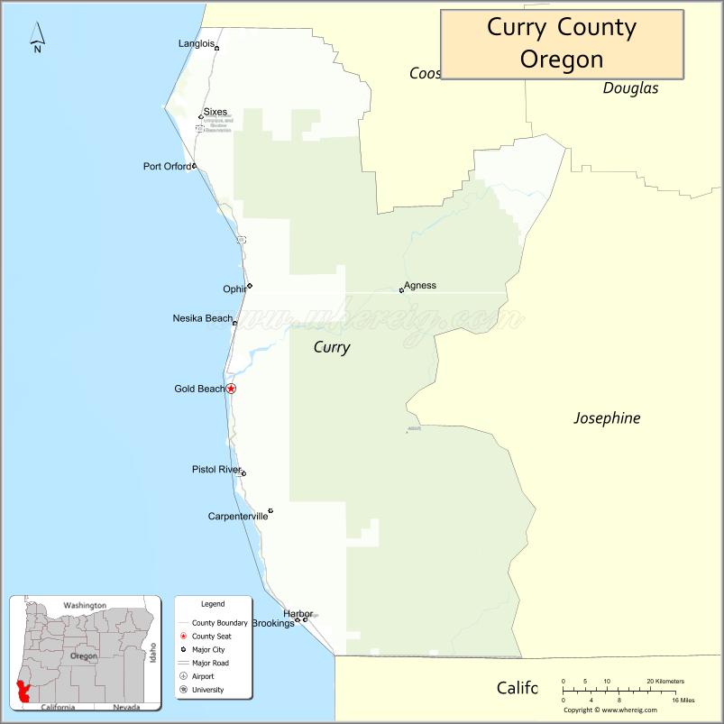
About Curry County Map, Oregon: The map showing the county boundary, county seat, major cities, highways, water bodies and neighbouring counties.
Oregon More Maps & Info
About Curry County, Oregon
Curry County is a county located in the U.S. state of Oregon. It's county seat is Gold Beach. As per 2020 census, the population of Curry County is 23683 people and population density is square miles. According to the United States Census Bureau, the county has a total area of 1,627 sq mi (4,214 km2). Curry County was established on 1855.
Curry County Facts
| Continent | North America |
| Country | United States |
| State | Oregon |
| County Seat | Gold Beach |
| Largest City/Town | Brookings |
| Established | 1855 |
| Total Area | 1,692 sq mi (4,382 sq km) |
| Land Area | 1,627 sq mi (4,214 sq km) |
| Water Area | 65 sq mi (168 sq km) |
| Population | 23,318 (Census 2020) |
| Population Density | 14.3 people per sq mi |
| Time Zone | Pacific Time Zone |
| Major Highways | U.S. Route 101, Oregon Route 42S |
| Major Rivers | Rogue River, Chetco River, Pistol River, Elk River |
| Neighboring Counties | Coos County, Josephine County, Del Norte County (CA) |
| Famous For | Pacific coastline, redwood forests, fishing, scenic drives, and outdoor recreation |
| Top Attractions | Samuel H. Boardman State Scenic Corridor, Rogue River, Harris Beach State Park, Cape Blanco nearby access, Redwood trails |
| Official Website | Official Website |
About Curry County, Oregon
Curry County is located along the southern Oregon coast in the United States and was established in 1855. The county seat is Gold Beach, while Brookings is the largest city in the county. The county is known for dramatic Pacific coastline scenery, coastal forests, rivers, fishing communities, and access to redwood groves near the California border.
Cities and Towns in Curry County, Oregon
| City/Town | Population (Census 2020) | Latitude & Longitude |
|---|---|---|
| Gold Beach (county seat) | 2,341 | 42.4073°N, 124.4218°W |
| Brookings | 6,744 | 42.0526°N, 124.2839°W |
| Port Orford | 1,146 | 42.7454°N, 124.4973°W |
| Harbor (CDP) | 2,695 | 42.0535°N, 124.2670°W |
| Wedderburn (CDP) | 473 | 42.4407°N, 124.4129°W |
| Nesika Beach (CDP) | 463 | 42.5435°N, 124.4057°W |
| Langlois (CDP) | 177 | 42.9187°N, 124.4560°W |
| Pistol River (CDP) | 213 | 42.2787°N, 124.3971°W |
Golf Courses in Curry County, Oregon
| Golf Course | Location | Latitude & Longitude |
|---|---|---|
| Salmon Run Golf Course | Brookings | 42.0682°N, 124.2985°W |
| Cedar Bend Golf Course | Gold Beach | 42.4203°N, 124.4048°W |
| Port Orford Cedar Bend Golf Area | Port Orford | 42.7424°N, 124.4960°W |
Roads and Highways in Curry County, Oregon
Major highways connect the county to nearby regions and cities.
- U.S. Route 101 - runs along the Pacific Coast and connects Brookings, Gold Beach, Port Orford, and coastal communities
- Oregon Route 42S - links coastal Curry County with inland Oregon and Coos County routes
Neighboring Counties of Curry County
- Coos County (north)
- Josephine County (east)
- Del Norte County, California (south)
Top Attractions in Curry County, Oregon
The county features several attractions known for history, nature, and recreation.
- Samuel H. Boardman State Scenic Corridor - coastal park known for cliffs, sea stacks, and scenic viewpoints
- Rogue River - popular destination for fishing, rafting, and jet boat tours
- Harris Beach State Park - oceanfront park with camping and beach access near Brookings
- Cape Blanco State Park - scenic coastal park with lighthouse views and hiking trails
- Redwood Nature Trails - nearby groves featuring giant coastal redwoods and walking paths
- Meyers Creek Beach - scenic beach area with dramatic Pacific coastline views
- Port Orford Heads State Park - historic coastal viewpoint with hiking opportunities
- Otter Point State Recreation Site - ocean overlook known for whale watching and photography
Distance from Curry County to Nearby Cities
The following distances are measured by road (driving).
- Gold Beach to Brookings (Curry County), Oregon - 28 mi (45 km)
- Gold Beach to Port Orford (Curry County), Oregon - 29 mi (47 km)
- Gold Beach to Coos Bay (Coos County), Oregon - 108 mi (174 km)
- Gold Beach to Grants Pass (Josephine County), Oregon - 82 mi (132 km)
- Gold Beach to Medford (Jackson County), Oregon - 124 mi (200 km)
- Gold Beach to Crescent City (Del Norte County), California - 42 mi (68 km)
- Gold Beach to Eureka (Humboldt County), California - 128 mi (206 km)
- Gold Beach to Roseburg (Douglas County), Oregon - 167 mi (269 km)
- Gold Beach to Eugene (Lane County), Oregon - 233 mi (375 km)
- Gold Beach to Salem (Marion County), Oregon - 283 mi (455 km)
- Gold Beach to Portland (Multnomah County), Oregon - 347 mi (558 km)
- Gold Beach to Bend (Deschutes County), Oregon - 301 mi (484 km)
FAQs about Curry County
Curry County is located along the southern Oregon coast near the California border.
Curry County had a population of 23,318 according to Census 2020 data.
Curry County is known for scenic Pacific coastline views, fishing, redwood forests, and outdoor recreation.
The county is primarily served by U.S. Route 101 and Oregon Route 42S.
Yes, Curry County has golf facilities including Salmon Run Golf Course in Brookings and Cedar Bend Golf Course near Gold Beach.
- Baker County Map
- Benton County Map
- Clackamas County Map
- Clatsop County Map
- Columbia County Map
- Coos County Map
- Crook County Map
- Curry County Map
- Deschutes County Map
- Douglas County Map
- Gilliam County Map
- Grant County Map
- Harney County Map
- Hood River County Map
- Jackson County Map
- Jefferson County Map
- Josephine County Map
- Klamath County Map
- Lake County Map
- Lane County Map
- Lincoln County Map
- Linn County Map
- Malheur County Map
- Marion County Map
- Morrow County Map
- Multnomah County Map
- Polk County Map
- Sherman County Map
- Tillamook County Map
- Umatilla County Map
- Union County Map
- Wallowa County Map
- Wasco County Map
- Washington County Map
- Wheeler County Map
- Yamhill County Map
- Alabama Counties
- Alaska boroughs
- Arizona Counties
- Arkansas Counties
- California County Map
- Colorado Counties
- Connecticut Counties
- Delaware Counties
- Florida County Map
- Georgia County Map
- Hawaii Counties
- Idaho Counties
- Illinois Counties
- Indiana Counties
- Iowa Counties
- Kansas Counties
- Kentucky Counties
- Louisiana Counties
- Maine Counties
- Maryland Counties
- Massachusetts Counties
- Michigan County Map
- Minnesota Counties
- Mississippi Counties
- Missouri Counties
- Montana Counties
- Nebraska Counties
- Nevada Counties
- New York Counties
- New Hampshire Counties
- New Jersey Counties
- New Mexico Counties
- North Carolina Counties
- North Dakota Counties
- Ohio County Map
- Oklahoma Counties
- Oregon Counties
- Pennsylvania Counties
- Rhode Island Counties
- South Carolina Counties
- South Dakota Counties
- Map of Tennessee
- Texas County Map
- Utah Counties
- Vermont Counties
- Virginia Counties
- Washington Counties
- West Virginia Counties
- Wisconsin Counties
- Wyoming Counties