Map of Jefferson County - Jefferson County is a county located in the U.S. state of Oregon. Jefferson County Map showing cities, highways, important places and water bodies. Get Where is Jefferson County located in the map, major cities in Jefferson county, population, areas, and places of interest.
Map of Jefferson County, Oregon
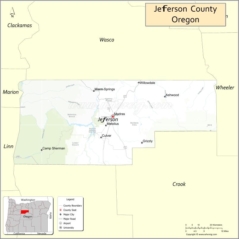
About Jefferson County Map, Oregon: The map showing the county boundary, county seat, major cities, highways, water bodies and neighbouring counties.
Oregon More Maps & Info
About Jefferson County, Oregon
Jefferson County is a county located in the U.S. state of Oregon. It's county seat is Madras. As per 2020 census, the population of Jefferson County is 25068 people and population density is square miles. According to the United States Census Bureau, the county has a total area of 1,781 sq mi (4,613 km2). Jefferson County was established on 1914.
Jefferson County Facts
| Continent | North America |
| Country | United States |
| State | Oregon |
| County Seat | Madras |
| Largest City/Town | Madras |
| Established | 1914 |
| Total Area | 1,791 sq mi (4,639 sq km) |
| Land Area | 1,781 sq mi (4,613 sq km) |
| Water Area | 10 sq mi (26 sq km) |
| Population | 24,502 (Census 2020) |
| Population Density | 13.8 people per sq mi |
| Time Zone | Pacific Time Zone |
| Major Highways | U.S. Route 26, U.S. Route 97, Oregon Route 361 |
| Major Rivers | Deschutes River, Crooked River, Metolius River |
| Neighboring Counties | Wasco County, Sherman County, Wheeler County, Crook County, Deschutes County, Marion County, Linn County |
| Famous For | High desert scenery, Warm Springs Reservation, agriculture, and outdoor recreation |
| Top Attractions | Lake Billy Chinook, Cove Palisades State Park, Warm Springs Museum, Deschutes River Canyon |
| Official Website | Official Website |
About Jefferson County, Oregon
Jefferson County is located in north-central Oregon in the United States and was established in 1914. The county seat and largest city is Madras. The county is known for high desert landscapes, scenic river canyons, Native American heritage, agricultural lands, and outdoor recreation areas surrounding central Oregon waterways.
Cities and Towns in Jefferson County, Oregon
| City/Town | Population (Census 2020) | Latitude & Longitude |
|---|---|---|
| Madras (county seat) | 7,744 | 44.6335°N, 121.1298°W |
| Culver | 1,473 | 44.5212°N, 121.2084°W |
| Metolius | 748 | 44.5807°N, 121.1790°W |
| Warm Springs | 2,945 | 44.7584°N, 121.2662°W |
| Camp Sherman (CDP) | 241 | 44.4423°N, 121.6453°W |
| Crooked River Ranch (CDP) | 5,699 | 44.4054°N, 121.2412°W |
| Gateway (CDP) | Not Officially Designated | 44.7569°N, 121.1461°W |
Golf Courses in Jefferson County, Oregon
| Golf Course | Location | Latitude & Longitude |
|---|---|---|
| Juniper Hills Country Club | Madras | 44.6391°N, 121.1236°W |
| Crooked River Ranch Golf Course | Crooked River Ranch | 44.4012°N, 121.2460°W |
| Kah-Nee-Ta Golf Course | Warm Springs | 44.8670°N, 121.1975°W |
Roads and Highways in Jefferson County, Oregon
Major highways connect the county to nearby regions and cities.
- U.S. Route 97 - major north-south highway linking Madras with Bend and The Dalles
- U.S. Route 26 - connects Madras with Portland, Prineville, and eastern Oregon communities
- Oregon Route 361 - scenic route connecting Culver and nearby recreation areas
Neighboring Counties of Jefferson County
- Wasco County (north)
- Sherman County (northeast)
- Wheeler County (east)
- Crook County (southeast)
- Deschutes County (south)
- Linn County (west)
- Marion County (northwest)
Top Attractions in Jefferson County, Oregon
The county features several attractions known for history, nature, and recreation.
- Lake Billy Chinook - reservoir known for boating, fishing, and canyon scenery
- The Cove Palisades State Park - recreation area with camping, hiking, and water sports
- Warm Springs Reservation - cultural and historical area home to the Confederated Tribes of Warm Springs
- Museum at Warm Springs - museum showcasing Native American culture and regional history
- Deschutes River Canyon - scenic canyon popular for rafting and photography
- Peter Skene Ogden State Scenic Viewpoint nearby access - dramatic bridge and canyon overlook
- Camp Sherman Area - forest recreation destination with fishing and hiking opportunities
- Metolius River Recreation Area - scenic river known for crystal-clear waters and mountain views
Distance from Jefferson County to Nearby Cities
The following distances are measured by road (driving).
- Madras to Bend (Deschutes County), Oregon - 42 mi (68 km)
- Madras to Redmond (Deschutes County), Oregon - 26 mi (42 km)
- Madras to Prineville (Crook County), Oregon - 42 mi (68 km)
- Madras to The Dalles (Wasco County), Oregon - 77 mi (124 km)
- Madras to Hood River (Hood River County), Oregon - 103 mi (166 km)
- Madras to Salem (Marion County), Oregon - 117 mi (188 km)
- Madras to Eugene (Lane County), Oregon - 136 mi (219 km)
- Madras to Portland (Multnomah County), Oregon - 122 mi (196 km)
- Madras to Pendleton (Umatilla County), Oregon - 160 mi (257 km)
- Madras to Burns (Harney County), Oregon - 171 mi (275 km)
- Madras to Medford (Jackson County), Oregon - 212 mi (341 km)
- Madras to Boise (Ada County), Idaho - 386 mi (621 km)
FAQs about Jefferson County
Jefferson County is located in north-central Oregon between the Columbia Plateau and central Oregon high desert regions.
Jefferson County had a population of 24,502 according to Census 2020 data.
Jefferson County is known for high desert scenery, Native American heritage, agriculture, and outdoor recreation.
The county is served by U.S. Route 26, U.S. Route 97, and Oregon Route 361.
Yes, Jefferson County has golf facilities including Juniper Hills Country Club and Crooked River Ranch Golf Course.
- Baker County Map
- Benton County Map
- Clackamas County Map
- Clatsop County Map
- Columbia County Map
- Coos County Map
- Crook County Map
- Curry County Map
- Deschutes County Map
- Douglas County Map
- Gilliam County Map
- Grant County Map
- Harney County Map
- Hood River County Map
- Jackson County Map
- Jefferson County Map
- Josephine County Map
- Klamath County Map
- Lake County Map
- Lane County Map
- Lincoln County Map
- Linn County Map
- Malheur County Map
- Marion County Map
- Morrow County Map
- Multnomah County Map
- Polk County Map
- Sherman County Map
- Tillamook County Map
- Umatilla County Map
- Union County Map
- Wallowa County Map
- Wasco County Map
- Washington County Map
- Wheeler County Map
- Yamhill County Map
- Alabama Counties
- Alaska boroughs
- Arizona Counties
- Arkansas Counties
- California County Map
- Colorado Counties
- Connecticut Counties
- Delaware Counties
- Florida County Map
- Georgia County Map
- Hawaii Counties
- Idaho Counties
- Illinois Counties
- Indiana Counties
- Iowa Counties
- Kansas Counties
- Kentucky Counties
- Louisiana Counties
- Maine Counties
- Maryland Counties
- Massachusetts Counties
- Michigan County Map
- Minnesota Counties
- Mississippi Counties
- Missouri Counties
- Montana Counties
- Nebraska Counties
- Nevada Counties
- New York Counties
- New Hampshire Counties
- New Jersey Counties
- New Mexico Counties
- North Carolina Counties
- North Dakota Counties
- Ohio County Map
- Oklahoma Counties
- Oregon Counties
- Pennsylvania Counties
- Rhode Island Counties
- South Carolina Counties
- South Dakota Counties
- Map of Tennessee
- Texas County Map
- Utah Counties
- Vermont Counties
- Virginia Counties
- Washington Counties
- West Virginia Counties
- Wisconsin Counties
- Wyoming Counties