Map of Sherman County - Sherman County is a county located in the U.S. state of Oregon. Sherman County Map showing cities, highways, important places and water bodies. Get Where is Sherman County located in the map, major cities in Sherman county, population, areas, and places of interest.
Map of Sherman County, Oregon
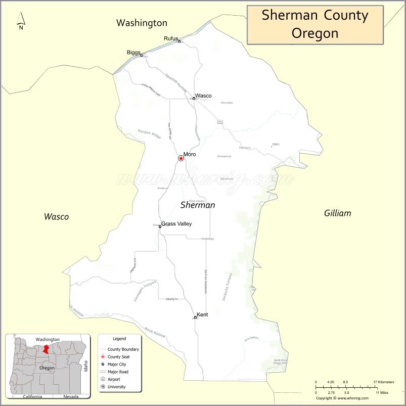
About Sherman County Map, Oregon: The map showing the county boundary, county seat, major cities, highways, water bodies and neighbouring counties.
Oregon More Maps & Info
About Sherman County, Oregon
Sherman County is a county located in the U.S. state of Oregon. It's county seat is Moro. As per 2020 census, the population of Sherman County is 1907 people and population density is square miles. According to the United States Census Bureau, the county has a total area of 823 sq mi (2,132 km2). Sherman County was established on 1889.
Sherman County Facts
| Continent | North America |
| Country | United States |
| State | Oregon |
| County Seat | Moro |
| Largest City/Town | Moro |
| Established | 1889 |
| Total Area | 831 sq mi (2,152 sq km) |
| Land Area | 824 sq mi (2,134 sq km) |
| Water Area | 7 sq mi (18 sq km) |
| Population | 1,870 (Census 2020) |
| Population Density | 2.3 people per sq mi |
| Time Zone | Pacific Time Zone |
| Major Highways | Interstate 84, U.S. Route 97, Oregon Route 206 |
| Major Rivers | John Day River, Deschutes River, Columbia River nearby access |
| Neighboring Counties | Wasco County, Gilliam County, Jefferson County, Morrow County |
| Famous For | Wheat farming, Columbia Plateau scenery, wind energy, and rural landscapes |
| Top Attractions | Historic grain elevators, scenic wheat fields, John Day River recreation, Oregon Trail history nearby |
| Official Website | Official Website |
About Sherman County, Oregon
Sherman County is located in north-central Oregon in the United States and was established in 1889. The county seat and largest city is Moro. The county is known for rolling wheat fields, rural communities, wind farms, scenic Columbia Plateau landscapes, and agricultural heritage in eastern Oregon.
Cities and Towns in Sherman County, Oregon
| City/Town | Population (Census 2020) | Latitude & Longitude |
|---|---|---|
| Moro (county seat) | 337 | 45.4843°N, 120.7317°W |
| Grass Valley | 164 | 45.3625°N, 120.7884°W |
| Kent | 65 | 45.2028°N, 120.6961°W |
| Rufus | 249 | 45.6940°N, 120.7492°W |
| Wasco | 381 | 45.5960°N, 120.6948°W |
| Biggs Junction | 90 | 45.6690°N, 120.8329°W |
Golf Courses in Sherman County, Oregon
| Golf Course | Location | Latitude & Longitude |
|---|---|---|
| Sherman County Golf Course | Moro | 45.4832°N, 120.7375°W |
| Wasco County Country Club nearby access | The Dalles Area | 45.6038°N, 121.1704°W |
Roads and Highways in Sherman County, Oregon
Major highways connect the county to nearby regions and cities.
- Interstate 84 - major east-west highway connecting the county with Portland and eastern Oregon
- U.S. Route 97 - north-south highway linking central Oregon with the Columbia River region
- Oregon Route 206 - scenic highway serving rural communities and agricultural areas
Neighboring Counties of Sherman County
- Wasco County (west)
- Gilliam County (east)
- Morrow County (east)
- Jefferson County (south)
Top Attractions in Sherman County, Oregon
The county features several attractions known for history, scenery, and recreation.
- John Day River Recreation Areas - fishing, rafting, and scenic canyon landscapes
- Historic Grain Elevators - iconic agricultural landmarks across the county
- Biggs Junction Area - Columbia River viewpoints and travel services
- Scenic Wheat Country Drives - rolling golden hills and panoramic rural scenery
- Oregon Trail nearby historic routes - regional pioneer history attractions
- Deschutes River nearby access - recreation opportunities including fishing and boating
- Wind Farm Viewing Areas - large-scale renewable energy projects across the plateau
- Rufus Riverfront Areas - Columbia River access for recreation and photography
Distance from Sherman County to Nearby Cities
The following distances are measured by road (driving).
- Moro to The Dalles (Wasco County), Oregon - 36 mi (58 km)
- Moro to Madras (Jefferson County), Oregon - 72 mi (116 km)
- Moro to Pendleton (Umatilla County), Oregon - 110 mi (177 km)
- Moro to Condon (Gilliam County), Oregon - 47 mi (76 km)
- Moro to Hood River (Hood River County), Oregon - 58 mi (93 km)
- Moro to Bend (Deschutes County), Oregon - 110 mi (177 km)
- Moro to Portland (Multnomah County), Oregon - 108 mi (174 km)
- Moro to Salem (Marion County), Oregon - 154 mi (248 km)
- Moro to Eugene (Lane County), Oregon - 192 mi (309 km)
- Moro to Boise (Ada County), Idaho - 335 mi (539 km)
- Moro to Astoria (Clatsop County), Oregon - 205 mi (330 km)
- Moro to Medford (Jackson County), Oregon - 274 mi (441 km)
FAQs about Sherman County
Sherman County is located in north-central Oregon on the Columbia Plateau.
Sherman County had a population of 1,870 according to Census 2020 data.
Sherman County is known for wheat farming, scenic rural landscapes, and wind energy projects.
The county is served by Interstate 84, U.S. Route 97, and Oregon Route 206.
Yes, Sherman County has golf facilities including Sherman County Golf Course near Moro.
- Baker County Map
- Benton County Map
- Clackamas County Map
- Clatsop County Map
- Columbia County Map
- Coos County Map
- Crook County Map
- Curry County Map
- Deschutes County Map
- Douglas County Map
- Gilliam County Map
- Grant County Map
- Harney County Map
- Hood River County Map
- Jackson County Map
- Jefferson County Map
- Josephine County Map
- Klamath County Map
- Lake County Map
- Lane County Map
- Lincoln County Map
- Linn County Map
- Malheur County Map
- Marion County Map
- Morrow County Map
- Multnomah County Map
- Polk County Map
- Sherman County Map
- Tillamook County Map
- Umatilla County Map
- Union County Map
- Wallowa County Map
- Wasco County Map
- Washington County Map
- Wheeler County Map
- Yamhill County Map
- Alabama Counties
- Alaska boroughs
- Arizona Counties
- Arkansas Counties
- California County Map
- Colorado Counties
- Connecticut Counties
- Delaware Counties
- Florida County Map
- Georgia County Map
- Hawaii Counties
- Idaho Counties
- Illinois Counties
- Indiana Counties
- Iowa Counties
- Kansas Counties
- Kentucky Counties
- Louisiana Counties
- Maine Counties
- Maryland Counties
- Massachusetts Counties
- Michigan County Map
- Minnesota Counties
- Mississippi Counties
- Missouri Counties
- Montana Counties
- Nebraska Counties
- Nevada Counties
- New York Counties
- New Hampshire Counties
- New Jersey Counties
- New Mexico Counties
- North Carolina Counties
- North Dakota Counties
- Ohio County Map
- Oklahoma Counties
- Oregon Counties
- Pennsylvania Counties
- Rhode Island Counties
- South Carolina Counties
- South Dakota Counties
- Map of Tennessee
- Texas County Map
- Utah Counties
- Vermont Counties
- Virginia Counties
- Washington Counties
- West Virginia Counties
- Wisconsin Counties
- Wyoming Counties