Map of Gilliam County - Gilliam County is a county located in the U.S. state of Oregon. Gilliam County Map showing cities, highways, important places and water bodies. Get Where is Gilliam County located in the map, major cities in Gilliam county, population, areas, and places of interest.
Map of Gilliam County, Oregon
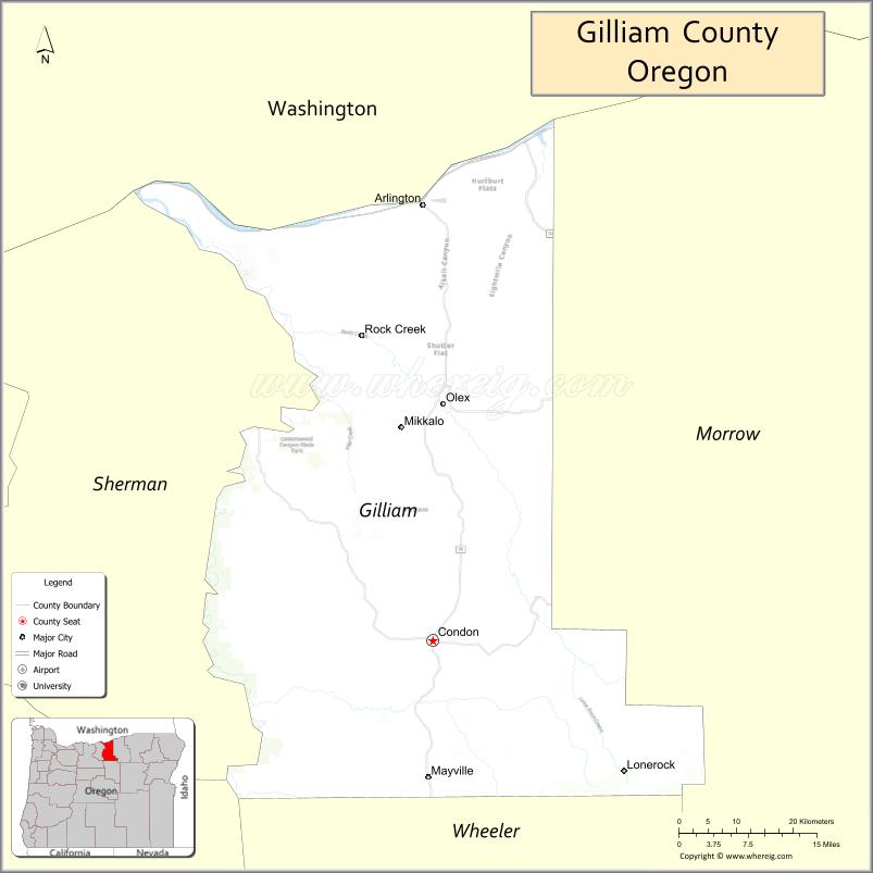
About Gilliam County Map, Oregon: The map showing the county boundary, county seat, major cities, highways, water bodies and neighbouring counties.
Oregon More Maps & Info
About Gilliam County, Oregon
Gilliam County is a county located in the U.S. state of Oregon. It's county seat is Condon. As per 2020 census, the population of Gilliam County is 2005 people and population density is square miles. According to the United States Census Bureau, the county has a total area of 1,204 sq mi (3,118 km2). Gilliam County was established on 1885.
Gilliam County Facts
| Continent | North America |
| Country | United States |
| State | Oregon |
| County Seat | Condon |
| Largest City/Town | Condon |
| Established | 1885 |
| Total Area | 1,223 sq mi (3,168 sq km) |
| Land Area | 1,205 sq mi (3,121 sq km) |
| Water Area | 18 sq mi (47 sq km) |
| Population | 1,995 (Census 2020) |
| Population Density | 1.7 people per sq mi |
| Time Zone | Pacific Time Zone |
| Major Highways | Oregon Route 19, Oregon Route 206, Interstate 84 |
| Major Rivers | John Day River, Columbia River |
| Neighboring Counties | Morrow County, Wheeler County, Sherman County |
| Famous For | Wheat farming, rolling hills, wind energy, and scenic Columbia Plateau landscapes |
| Top Attractions | John Day River, Cottonwood Canyon State Park nearby access, historic Condon sites, scenic drives |
| Official Website | Official Website |
About Gilliam County, Oregon
Gilliam County is located in north-central Oregon in the United States and was established in 1885. The county seat is Condon, which is also the largest city in the county. The county is known for rolling wheat fields, open rangelands, Columbia Plateau scenery, and agricultural communities surrounded by scenic hills and river canyons.
Cities and Towns in Gilliam County, Oregon
| City/Town | Population (Census 2020) | Latitude & Longitude |
|---|---|---|
| Condon (county seat) | 682 | 45.2343°N, 120.1831°W |
| Arlington | 586 | 45.7160°N, 120.2001°W |
| Lonerock | 65 | 45.4960°N, 119.9119°W |
| Ferry Canyon (CDP) | Not Officially Designated | 45.4705°N, 120.0837°W |
Golf Courses in Gilliam County, Oregon
| Golf Course | Location | Latitude & Longitude |
|---|---|---|
| Arlington Golf Course | Arlington | 45.7148°N, 120.1935°W |
| Condon Golf Course | Condon | 45.2401°N, 120.1778°W |
Roads and Highways in Gilliam County, Oregon
Major highways connect the county to nearby regions and cities.
- Interstate 84 - runs along the Columbia River and connects Arlington with The Dalles and Pendleton
- Oregon Route 19 - links Arlington, Condon, and central Oregon farming communities
- Oregon Route 206 - connects Condon with Wasco County and eastern Oregon routes
Neighboring Counties of Gilliam County
- Sherman County (west)
- Morrow County (east)
- Wheeler County (south)
Top Attractions in Gilliam County, Oregon
The county features several attractions known for history, nature, and recreation.
- John Day River - scenic river popular for fishing, rafting, and wildlife viewing
- Cottonwood Canyon State Park nearby access - outdoor recreation area with hiking and camping opportunities
- Condon Historical Museum - local museum featuring pioneer and agricultural history
- Arlington Marina - Columbia River boating and fishing destination
- Gilliam County Fairgrounds - community event venue hosting local fairs and rodeos
- Scenic Wheat Country Drives - rolling landscape routes known for seasonal golden wheat fields
- Thirtymile Canyon Area - scenic canyon landscape along the John Day River
- Lonerock Historic Area - small historic farming community with rural scenery
Distance from Gilliam County to Nearby Cities
The following distances are measured by road (driving).
- Condon to Arlington (Gilliam County), Oregon - 39 mi (63 km)
- Condon to The Dalles (Wasco County), Oregon - 92 mi (148 km)
- Condon to Pendleton (Umatilla County), Oregon - 99 mi (159 km)
- Condon to Hermiston (Umatilla County), Oregon - 82 mi (132 km)
- Condon to Heppner (Morrow County), Oregon - 71 mi (114 km)
- Condon to Bend (Deschutes County), Oregon - 139 mi (224 km)
- Condon to Salem (Marion County), Oregon - 172 mi (277 km)
- Condon to Portland (Multnomah County), Oregon - 165 mi (266 km)
- Condon to John Day (Grant County), Oregon - 112 mi (180 km)
- Condon to Hood River (Hood River County), Oregon - 107 mi (172 km)
- Condon to La Grande (Union County), Oregon - 150 mi (241 km)
- Condon to Boise (Ada County), Idaho - 311 mi (500 km)
FAQs about Gilliam County
Gilliam County is located in north-central Oregon along the Columbia Plateau region.
Gilliam County had a population of 1,995 according to Census 2020 data.
Gilliam County is known for wheat farming, rolling hills, scenic rural landscapes, and Columbia River recreation.
The county is served by Interstate 84, Oregon Route 19, and Oregon Route 206.
Yes, Gilliam County has local golf facilities including Arlington Golf Course and Condon Golf Course.
- Baker County Map
- Benton County Map
- Clackamas County Map
- Clatsop County Map
- Columbia County Map
- Coos County Map
- Crook County Map
- Curry County Map
- Deschutes County Map
- Douglas County Map
- Gilliam County Map
- Grant County Map
- Harney County Map
- Hood River County Map
- Jackson County Map
- Jefferson County Map
- Josephine County Map
- Klamath County Map
- Lake County Map
- Lane County Map
- Lincoln County Map
- Linn County Map
- Malheur County Map
- Marion County Map
- Morrow County Map
- Multnomah County Map
- Polk County Map
- Sherman County Map
- Tillamook County Map
- Umatilla County Map
- Union County Map
- Wallowa County Map
- Wasco County Map
- Washington County Map
- Wheeler County Map
- Yamhill County Map
- Alabama Counties
- Alaska boroughs
- Arizona Counties
- Arkansas Counties
- California County Map
- Colorado Counties
- Connecticut Counties
- Delaware Counties
- Florida County Map
- Georgia County Map
- Hawaii Counties
- Idaho Counties
- Illinois Counties
- Indiana Counties
- Iowa Counties
- Kansas Counties
- Kentucky Counties
- Louisiana Counties
- Maine Counties
- Maryland Counties
- Massachusetts Counties
- Michigan County Map
- Minnesota Counties
- Mississippi Counties
- Missouri Counties
- Montana Counties
- Nebraska Counties
- Nevada Counties
- New York Counties
- New Hampshire Counties
- New Jersey Counties
- New Mexico Counties
- North Carolina Counties
- North Dakota Counties
- Ohio County Map
- Oklahoma Counties
- Oregon Counties
- Pennsylvania Counties
- Rhode Island Counties
- South Carolina Counties
- South Dakota Counties
- Map of Tennessee
- Texas County Map
- Utah Counties
- Vermont Counties
- Virginia Counties
- Washington Counties
- West Virginia Counties
- Wisconsin Counties
- Wyoming Counties