Map of Hood River County - Hood River County is a county located in the U.S. state of Oregon. Hood River County Map showing cities, highways, important places and water bodies. Get Where is Hood River County located in the map, major cities in Hood River county, population, areas, and places of interest.
Map of Hood River County, Oregon
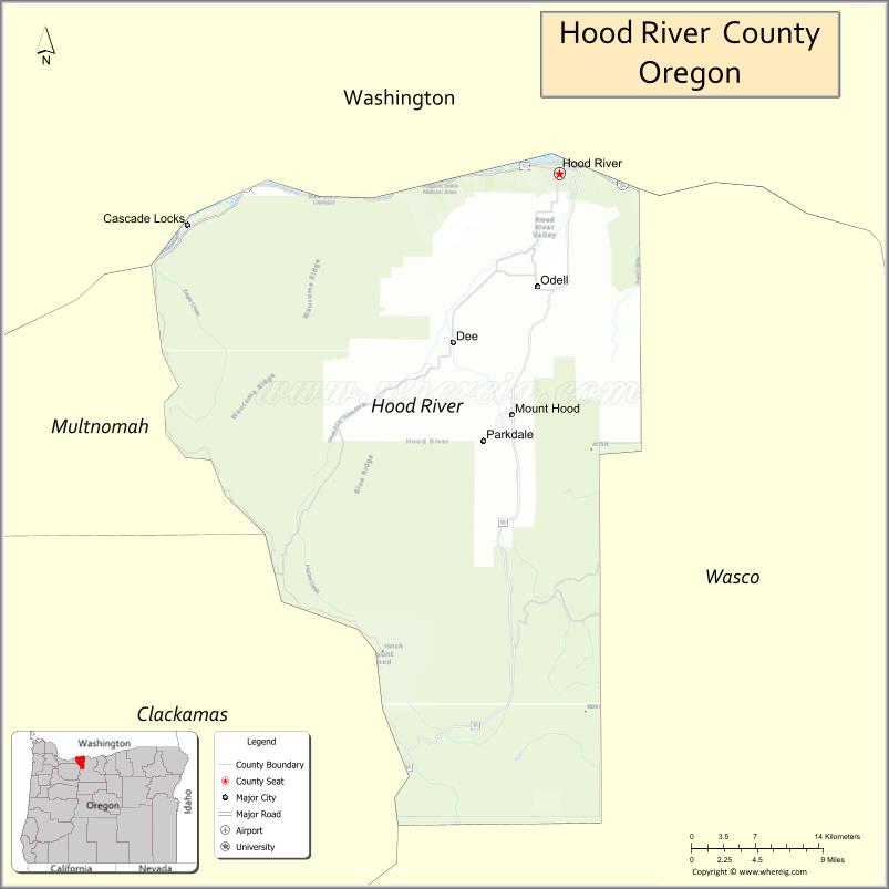
About Hood River County Map, Oregon: The map showing the county boundary, county seat, major cities, highways, water bodies and neighbouring counties.
Oregon More Maps & Info
About Hood River County, Oregon
Hood River County is a county located in the U.S. state of Oregon. It's county seat is Hood River. As per 2020 census, the population of Hood River County is 24057 people and population density is square miles. According to the United States Census Bureau, the county has a total area of 522 sq mi (1,352 km2). Hood River County was established on 1908.
Hood River County Facts
| Continent | North America |
| Country | United States |
| State | Oregon |
| County Seat | Hood River |
| Largest City/Town | Hood River |
| Established | 1908 |
| Total Area | 533 sq mi (1,380 sq km) |
| Land Area | 522 sq mi (1,352 sq km) |
| Water Area | 11 sq mi (28 sq km) |
| Population | 23,973 (Census 2020) |
| Population Density | 45.9 people per sq mi |
| Time Zone | Pacific Time Zone |
| Major Highways | Interstate 84, U.S. Route 30, Oregon Route 35, Oregon Route 281 |
| Major Rivers | Columbia River, Hood River, White Salmon River |
| Neighboring Counties | Wasco County, Multnomah County, Klickitat County (WA), Skamania County (WA) |
| Famous For | Windsurfing, orchards, Columbia River Gorge scenery, and outdoor recreation |
| Top Attractions | Columbia River Gorge, Mount Hood nearby access, Hood River Fruit Loop, waterfalls, windsurfing areas |
| Official Website | Official Website |
About Hood River County, Oregon
Hood River County is located in north-central Oregon in the United States and was established in 1908. The county seat is Hood River, which is also the largest city in the county. The county sits within the Columbia River Gorge and is known for mountain scenery, orchards, vineyards, outdoor recreation, and world-famous windsurfing conditions.
Cities and Towns in Hood River County, Oregon
| City/Town | Population (Census 2020) | Latitude & Longitude |
|---|---|---|
| Hood River (county seat) | 8,309 | 45.7054°N, 121.5215°W |
| Cascade Locks | 1,144 | 45.6698°N, 121.8906°W |
| Parkdale | 311 | 45.5190°N, 121.5962°W |
| Odell (CDP) | 2,273 | 45.6279°N, 121.5367°W |
| Pine Grove (CDP) | 1,525 | 45.6648°N, 121.5364°W |
| Mount Hood (CDP) | 734 | 45.4212°N, 121.5362°W |
| Dee (CDP) | Not Officially Designated | 45.6045°N, 121.6413°W |
Golf Courses in Hood River County, Oregon
| Golf Course | Location | Latitude & Longitude |
|---|---|---|
| Indian Creek Golf Course | Hood River | 45.6993°N, 121.5467°W |
| Hood River Golf and Country Club | Hood River | 45.6940°N, 121.5541°W |
| Skamania Lodge Golf Course | Cascade Locks | 45.6815°N, 121.8847°W |
Roads and Highways in Hood River County, Oregon
Major highways connect the county to nearby regions and cities.
- Interstate 84 - major east-west route through the Columbia River Gorge connecting Hood River with Portland and The Dalles
- U.S. Route 30 - scenic historic highway following sections of the Columbia River Gorge
- Oregon Route 35 - connects Hood River with Mount Hood and central Oregon routes
- Oregon Route 281 - links Hood River with agricultural and orchard communities south of the city
Neighboring Counties of Hood River County
- Multnomah County (west)
- Wasco County (east and south)
- Skamania County, Washington (northwest)
- Klickitat County, Washington (north)
Top Attractions in Hood River County, Oregon
The county features several attractions known for history, nature, and recreation.
- Columbia River Gorge - scenic canyon area famous for waterfalls, hiking, and panoramic river views
- Hood River Fruit Loop - driving route featuring orchards, wineries, and farm stands
- Mount Hood nearby access - gateway to skiing, hiking, and mountain recreation areas
- Windsurfing and Kiteboarding Areas - internationally known recreation sites along the Columbia River
- Multnomah Falls nearby access - famous waterfall destination west of Hood River
- Punchbowl Falls Trails - scenic hiking routes through forested gorge landscapes
- Panorama Point County Park - viewpoint offering orchard and mountain scenery
- History Museum of Hood River County - museum showcasing local history and pioneer exhibits
Distance from Hood River County to Nearby Cities
The following distances are measured by road (driving).
- Hood River to The Dalles (Wasco County), Oregon - 21 mi (34 km)
- Hood River to Portland (Multnomah County), Oregon - 63 mi (101 km)
- Hood River to Vancouver (Clark County), Washington - 66 mi (106 km)
- Hood River to Salem (Marion County), Oregon - 109 mi (175 km)
- Hood River to Bend (Deschutes County), Oregon - 145 mi (233 km)
- Hood River to Pendleton (Umatilla County), Oregon - 142 mi (229 km)
- Hood River to Astoria (Clatsop County), Oregon - 181 mi (291 km)
- Hood River to Eugene (Lane County), Oregon - 171 mi (275 km)
- Hood River to Yakima (Yakima County), Washington - 113 mi (182 km)
- Hood River to Olympia (Thurston County), Washington - 177 mi (285 km)
- Hood River to Boise (Ada County), Idaho - 342 mi (550 km)
- Hood River to Medford (Jackson County), Oregon - 286 mi (460 km)
FAQs about Hood River County
Hood River County is located in north-central Oregon within the Columbia River Gorge region.
Hood River County had a population of 23,973 according to Census 2020 data.
Hood River County is known for windsurfing, orchards, scenic gorge landscapes, and outdoor recreation.
The county is served by Interstate 84, U.S. Route 30, Oregon Route 35, and Oregon Route 281.
Yes, Hood River County has golf facilities including Indian Creek Golf Course and Hood River Golf and Country Club.
- Baker County Map
- Benton County Map
- Clackamas County Map
- Clatsop County Map
- Columbia County Map
- Coos County Map
- Crook County Map
- Curry County Map
- Deschutes County Map
- Douglas County Map
- Gilliam County Map
- Grant County Map
- Harney County Map
- Hood River County Map
- Jackson County Map
- Jefferson County Map
- Josephine County Map
- Klamath County Map
- Lake County Map
- Lane County Map
- Lincoln County Map
- Linn County Map
- Malheur County Map
- Marion County Map
- Morrow County Map
- Multnomah County Map
- Polk County Map
- Sherman County Map
- Tillamook County Map
- Umatilla County Map
- Union County Map
- Wallowa County Map
- Wasco County Map
- Washington County Map
- Wheeler County Map
- Yamhill County Map
- Alabama Counties
- Alaska boroughs
- Arizona Counties
- Arkansas Counties
- California County Map
- Colorado Counties
- Connecticut Counties
- Delaware Counties
- Florida County Map
- Georgia County Map
- Hawaii Counties
- Idaho Counties
- Illinois Counties
- Indiana Counties
- Iowa Counties
- Kansas Counties
- Kentucky Counties
- Louisiana Counties
- Maine Counties
- Maryland Counties
- Massachusetts Counties
- Michigan County Map
- Minnesota Counties
- Mississippi Counties
- Missouri Counties
- Montana Counties
- Nebraska Counties
- Nevada Counties
- New York Counties
- New Hampshire Counties
- New Jersey Counties
- New Mexico Counties
- North Carolina Counties
- North Dakota Counties
- Ohio County Map
- Oklahoma Counties
- Oregon Counties
- Pennsylvania Counties
- Rhode Island Counties
- South Carolina Counties
- South Dakota Counties
- Map of Tennessee
- Texas County Map
- Utah Counties
- Vermont Counties
- Virginia Counties
- Washington Counties
- West Virginia Counties
- Wisconsin Counties
- Wyoming Counties