Map of Clatsop County - Clatsop County is a county located in the U.S. state of Oregon. Clatsop County Map showing cities, highways, important places and water bodies. Get Where is Clatsop County located in the map, major cities in Clatsop county, population, areas, and places of interest.
Map of Clatsop County, Oregon
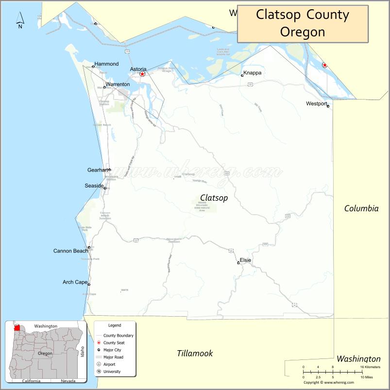
About Clatsop County Map, Oregon: The map showing the county boundary, county seat, major cities, highways, water bodies and neighbouring counties.
Oregon More Maps & Info
About Clatsop County, Oregon
Clatsop County is a county located in the U.S. state of Oregon. It's county seat is Astoria. As per 2020 census, the population of Clatsop County is 41810 people and population density is square miles. According to the United States Census Bureau, the county has a total area of 827 sq mi (2,142 km2). Clatsop County was established on 1844.
Clatsop County Facts
| Continent | North America |
| Country | United States |
| State | Oregon |
| County Seat | Astoria |
| Largest City/Town | Astoria |
| Established | 1844 |
| Total Area | 1,084 sq mi (2,808 sq km) |
| Land Area | 829 sq mi (2,147 sq km) |
| Water Area | 255 sq mi (660 sq km) |
| Population | 41,072 (Census 2020) |
| Population Density | 49.5 people per sq mi |
| Time Zone | Pacific Time Zone |
| Major Highways | U.S. Route 101, U.S. Route 26, Oregon Route 202, Oregon Route 103 |
| Major Rivers | Columbia River, Necanicum River, Youngs River, Lewis and Clark River |
| Neighboring Counties | Columbia County, Tillamook County, Pacific County (WA), Wahkiakum County (WA) |
| Famous For | Pacific coastline, Lewis and Clark history, fishing industry, and scenic beaches |
| Top Attractions | Astoria Column, Cannon Beach nearby access, Fort Stevens State Park, Seaside Promenade, Lewis and Clark National Historical Park |
| Official Website | Official Website |
About Clatsop County, Oregon
Clatsop County is located in the northwestern corner of Oregon in the United States and was established in 1844. The county seat is Astoria, which is also the largest city in the county. The county borders the Pacific Ocean and the Columbia River and is known for coastal scenery, maritime history, forests, and historic Lewis and Clark expedition sites.
Cities and Towns in Clatsop County, Oregon
| City/Town | Population (Census 2020) | Latitude & Longitude |
|---|---|---|
| Astoria (county seat) | 9,477 | 46.1879°N, 123.8313°W |
| Cannon Beach | 1,489 | 45.8918°N, 123.9615°W |
| Gearhart | 1,911 | 46.0243°N, 123.9118°W |
| Hammond | 322 | 46.1987°N, 123.9493°W |
| Jewell | Not Incorporated | 45.9330°N, 123.5037°W |
| Seaside | 6,457 | 45.9932°N, 123.9226°W |
| Warrenton | 6,429 | 46.1657°N, 123.9238°W |
| Westport (CDP) | 321 | 46.1326°N, 123.3768°W |
| Knappa (CDP) | 499 | 46.1715°N, 123.6057°W |
| Svensen (CDP) | 738 | 46.1618°N, 123.7563°W |
Golf Courses in Clatsop County, Oregon
| Golf Course | Location | Latitude & Longitude |
|---|---|---|
| Astoria Golf and Country Club | Warrenton | 46.1237°N, 123.8998°W |
| Gearhart Golf Links | Gearhart | 46.0189°N, 123.9162°W |
| Highlands Golf Club | Seaside | 45.9787°N, 123.9145°W |
Roads and Highways in Clatsop County, Oregon
Major highways connect the county to nearby regions and cities.
- U.S. Route 101 - runs along the Pacific Coast and connects Astoria, Warrenton, Seaside, and Cannon Beach
- U.S. Route 26 - links Clatsop County with Portland and inland Oregon communities
- Oregon Route 202 - connects Astoria with rural eastern areas of the county
- Oregon Route 103 - follows the Columbia River corridor toward Columbia County
Neighboring Counties of Clatsop County
- Pacific County, Washington (north)
- Wahkiakum County, Washington (northeast)
- Columbia County, Oregon (east)
- Tillamook County, Oregon (south)
Top Attractions in Clatsop County, Oregon
The county features several attractions known for history, nature, and recreation.
- Astoria Column - historic tower offering panoramic views of the Columbia River and Pacific coast
- Fort Stevens State Park - large coastal park with beaches, trails, and military history sites
- Lewis and Clark National Historical Park - preserves important expedition landmarks and visitor centers
- Seaside Promenade - popular oceanfront walking area along the beach
- Cannon Beach - scenic coastal town known for Haystack Rock and sandy beaches
- Columbia River Maritime Museum - museum focused on regional maritime history and ship navigation
- Ecola State Park - scenic coastal park with hiking trails and ocean viewpoints
- Gearhart Beach - quiet coastal beach area popular for walking and recreation
Distance from Clatsop County to Nearby Cities
The following distances are measured by road (driving).
- Astoria to Seaside (Clatsop County), Oregon - 17 mi (27 km)
- Astoria to Cannon Beach (Clatsop County), Oregon - 26 mi (42 km)
- Astoria to Tillamook (Tillamook County), Oregon - 61 mi (98 km)
- Astoria to Portland (Multnomah County), Oregon - 97 mi (156 km)
- Astoria to Longview (Cowlitz County), Washington - 59 mi (95 km)
- Astoria to Vancouver (Clark County), Washington - 92 mi (148 km)
- Astoria to Newport (Lincoln County), Oregon - 133 mi (214 km)
- Astoria to Salem (Marion County), Oregon - 111 mi (179 km)
- Astoria to Aberdeen (Grays Harbor County), Washington - 84 mi (135 km)
- Astoria to Olympia (Thurston County), Washington - 138 mi (222 km)
- Astoria to Eugene (Lane County), Oregon - 176 mi (283 km)
- Astoria to Bend (Deschutes County), Oregon - 241 mi (388 km)
FAQs about Clatsop County
Clatsop County is located in northwestern Oregon along the Pacific Ocean and the Columbia River.
Clatsop County had a population of 41,072 according to Census 2020 data.
Clatsop County is known for coastal scenery, maritime history, Lewis and Clark sites, beaches, and fishing communities.
The county is served by U.S. Route 101, U.S. Route 26, Oregon Route 202, and Oregon Route 103.
Yes, Clatsop County has several golf facilities including Gearhart Golf Links and Astoria Golf and Country Club.
- Baker County Map
- Benton County Map
- Clackamas County Map
- Clatsop County Map
- Columbia County Map
- Coos County Map
- Crook County Map
- Curry County Map
- Deschutes County Map
- Douglas County Map
- Gilliam County Map
- Grant County Map
- Harney County Map
- Hood River County Map
- Jackson County Map
- Jefferson County Map
- Josephine County Map
- Klamath County Map
- Lake County Map
- Lane County Map
- Lincoln County Map
- Linn County Map
- Malheur County Map
- Marion County Map
- Morrow County Map
- Multnomah County Map
- Polk County Map
- Sherman County Map
- Tillamook County Map
- Umatilla County Map
- Union County Map
- Wallowa County Map
- Wasco County Map
- Washington County Map
- Wheeler County Map
- Yamhill County Map
- Alabama Counties
- Alaska boroughs
- Arizona Counties
- Arkansas Counties
- California County Map
- Colorado Counties
- Connecticut Counties
- Delaware Counties
- Florida County Map
- Georgia County Map
- Hawaii Counties
- Idaho Counties
- Illinois Counties
- Indiana Counties
- Iowa Counties
- Kansas Counties
- Kentucky Counties
- Louisiana Counties
- Maine Counties
- Maryland Counties
- Massachusetts Counties
- Michigan County Map
- Minnesota Counties
- Mississippi Counties
- Missouri Counties
- Montana Counties
- Nebraska Counties
- Nevada Counties
- New York Counties
- New Hampshire Counties
- New Jersey Counties
- New Mexico Counties
- North Carolina Counties
- North Dakota Counties
- Ohio County Map
- Oklahoma Counties
- Oregon Counties
- Pennsylvania Counties
- Rhode Island Counties
- South Carolina Counties
- South Dakota Counties
- Map of Tennessee
- Texas County Map
- Utah Counties
- Vermont Counties
- Virginia Counties
- Washington Counties
- West Virginia Counties
- Wisconsin Counties
- Wyoming Counties