Map of Wallowa County - Wallowa County is a county located in the U.S. state of Oregon. Wallowa County Map showing cities, highways, important places and water bodies. Get Where is Wallowa County located in the map, major cities in Wallowa county, population, areas, and places of interest.
Map of Wallowa County, Oregon
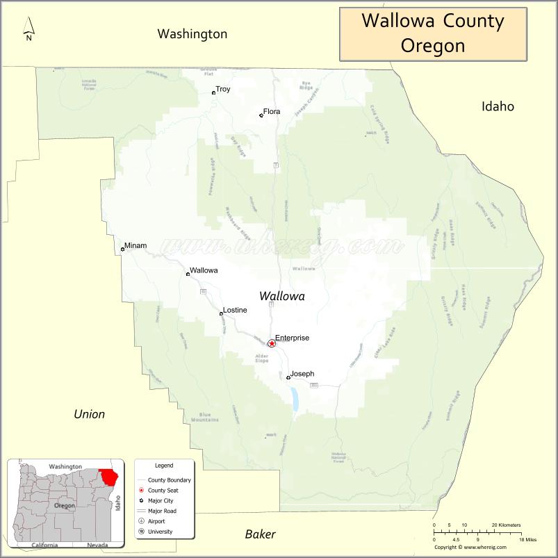
About Wallowa County Map, Oregon: The map showing the county boundary, county seat, major cities, highways, water bodies and neighbouring counties.
Oregon More Maps & Info
About Wallowa County, Oregon
Wallowa County is a county located in the U.S. state of Oregon. It's county seat is Enterprise. As per 2020 census, the population of Wallowa County is 7545 people and population density is square miles. According to the United States Census Bureau, the county has a total area of 3,145 sq mi (8,146 km2). Wallowa County was established on 1887.
Wallowa County Facts
| Continent | North America |
| Country | United States |
| State | Oregon |
| County Seat | Enterprise |
| Largest City/Town | Enterprise |
| Established | 1887 |
| Total Area | 3,152 sq mi (8,164 sq km) |
| Land Area | 3,146 sq mi (8,148 sq km) |
| Water Area | 6 sq mi (16 sq km) |
| Population | 7,391 (Census 2020) |
| Population Density | 2.3 people per sq mi |
| Time Zone | Pacific Time Zone |
| Major Highways | Oregon Route 82, Oregon Route 350, Oregon Route 3 nearby access |
| Major Rivers | Wallowa River, Grande Ronde River, Imnaha River |
| Neighboring Counties | Union County, Umatilla County, Asotin County (WA), Nez Perce County (ID), Idaho County (ID) |
| Famous For | Wallowa Mountains, Hells Canyon, outdoor recreation, and ranching heritage |
| Top Attractions | Wallowa Lake, Hells Canyon, Eagle Cap Wilderness, Joseph arts community, scenic mountain drives |
| Official Website | Official Website |
About Wallowa County, Oregon
Wallowa County is located in northeastern Oregon in the United States and was established in 1887. The county seat and largest city is Enterprise. The county is known for rugged mountain scenery, ranching communities, wilderness recreation, alpine lakes, and the dramatic landscapes of Hells Canyon and the Wallowa Mountains.
Cities and Towns in Wallowa County, Oregon
| City/Town | Population (Census 2020) | Latitude & Longitude |
|---|---|---|
| Enterprise (county seat) | 1,940 | 45.4268°N, 117.2788°W |
| Joseph | 1,124 | 45.3546°N, 117.2290°W |
| Lostine | 213 | 45.4935°N, 117.4327°W |
| Wallowa | 808 | 45.5712°N, 117.5277°W |
| Imnaha | 120 | 45.5590°N, 116.8335°W |
| Troy | 35 | 45.9479°N, 117.4507°W |
Golf Courses in Wallowa County, Oregon
| Golf Course | Location | Latitude & Longitude |
|---|---|---|
| Alpine Meadows Golf Course | Enterprise | 45.4258°N, 117.2863°W |
| Wallowa Lake Golf Course | Joseph | 45.3149°N, 117.2058°W |
Roads and Highways in Wallowa County, Oregon
Major highways connect the county to nearby regions and scenic destinations.
- Oregon Route 82 - primary highway connecting Enterprise, Joseph, and Wallowa Valley communities
- Oregon Route 350 - scenic route serving rural ranching and mountain recreation areas
- Oregon Route 3 nearby access - connects northeastern Oregon with Washington and Idaho regions
Neighboring Counties of Wallowa County
- Union County (west)
- Umatilla County (northwest)
- Asotin County, Washington (north)
- Nez Perce County, Idaho (east)
- Idaho County, Idaho (south and southeast)
Top Attractions in Wallowa County, Oregon
The county features several attractions known for wilderness, recreation, and mountain scenery.
- Wallowa Lake - alpine lake destination known for boating, fishing, and mountain views
- Hells Canyon National Recreation Area - dramatic canyon landscape and outdoor adventure destination
- Eagle Cap Wilderness - wilderness area popular for hiking, backpacking, and horseback riding
- Wallowa Lake Tramway - scenic tram ride offering panoramic mountain views
- Joseph Arts Community - galleries and bronze sculpture attractions in downtown Joseph
- Zumwalt Prairie Preserve - grassland ecosystem and wildlife viewing area
- Chief Joseph Days Rodeo - annual rodeo celebrating western heritage and ranching traditions
- Imnaha River Recreation Areas - fishing, rafting, and scenic canyon landscapes
Distance from Wallowa County to Nearby Cities
The following distances are measured by road (driving).
- Enterprise to La Grande (Union County), Oregon - 69 mi (111 km)
- Enterprise to Pendleton (Umatilla County), Oregon - 122 mi (196 km)
- Enterprise to Lewiston (Nez Perce County), Idaho - 105 mi (169 km)
- Enterprise to Walla Walla (Walla Walla County), Washington - 129 mi (208 km)
- Enterprise to Baker City (Baker County), Oregon - 131 mi (211 km)
- Enterprise to Boise (Ada County), Idaho - 247 mi (398 km)
- Enterprise to Bend (Deschutes County), Oregon - 300 mi (483 km)
- Enterprise to Portland (Multnomah County), Oregon - 329 mi (529 km)
- Enterprise to Spokane (Spokane County), Washington - 210 mi (338 km)
- Enterprise to Salem (Marion County), Oregon - 343 mi (552 km)
- Enterprise to Seattle (King County), Washington - 397 mi (639 km)
- Enterprise to Medford (Jackson County), Oregon - 390 mi (628 km)
FAQs about Wallowa County
Wallowa County is located in northeastern Oregon near the Idaho and Washington borders.
Wallowa County had a population of 7,391 according to Census 2020 data.
Wallowa County is known for the Wallowa Mountains, Hells Canyon, wilderness recreation, and ranching heritage.
The county is served mainly by Oregon Route 82 and scenic regional highways through mountain valleys.
Yes, Wallowa County has golf facilities including Alpine Meadows Golf Course and Wallowa Lake Golf Course.
- Baker County Map
- Benton County Map
- Clackamas County Map
- Clatsop County Map
- Columbia County Map
- Coos County Map
- Crook County Map
- Curry County Map
- Deschutes County Map
- Douglas County Map
- Gilliam County Map
- Grant County Map
- Harney County Map
- Hood River County Map
- Jackson County Map
- Jefferson County Map
- Josephine County Map
- Klamath County Map
- Lake County Map
- Lane County Map
- Lincoln County Map
- Linn County Map
- Malheur County Map
- Marion County Map
- Morrow County Map
- Multnomah County Map
- Polk County Map
- Sherman County Map
- Tillamook County Map
- Umatilla County Map
- Union County Map
- Wallowa County Map
- Wasco County Map
- Washington County Map
- Wheeler County Map
- Yamhill County Map
- Alabama Counties
- Alaska boroughs
- Arizona Counties
- Arkansas Counties
- California County Map
- Colorado Counties
- Connecticut Counties
- Delaware Counties
- Florida County Map
- Georgia County Map
- Hawaii Counties
- Idaho Counties
- Illinois Counties
- Indiana Counties
- Iowa Counties
- Kansas Counties
- Kentucky Counties
- Louisiana Counties
- Maine Counties
- Maryland Counties
- Massachusetts Counties
- Michigan County Map
- Minnesota Counties
- Mississippi Counties
- Missouri Counties
- Montana Counties
- Nebraska Counties
- Nevada Counties
- New York Counties
- New Hampshire Counties
- New Jersey Counties
- New Mexico Counties
- North Carolina Counties
- North Dakota Counties
- Ohio County Map
- Oklahoma Counties
- Oregon Counties
- Pennsylvania Counties
- Rhode Island Counties
- South Carolina Counties
- South Dakota Counties
- Map of Tennessee
- Texas County Map
- Utah Counties
- Vermont Counties
- Virginia Counties
- Washington Counties
- West Virginia Counties
- Wisconsin Counties
- Wyoming Counties