Map of Marion County - Marion County is a county located in the U.S. state of Oregon. Marion County Map showing cities, highways, important places and water bodies. Get Where is Marion County located in the map, major cities in Marion county, population, areas, and places of interest.
Map of Marion County, Oregon
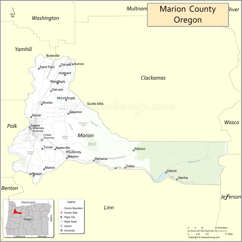
About Marion County Map, Oregon: The map showing the county boundary, county seat, major cities, highways, water bodies and neighbouring counties.
Oregon More Maps & Info
About Marion County, Oregon
Marion County is a county located in the U.S. state of Oregon. It's county seat is Salem. As per 2020 census, the population of Marion County is 347119 people and population density is square miles. According to the United States Census Bureau, the county has a total area of 1,185 sq mi (3,069 km2). Marion County was established on 1843.
Marion County Facts
| Continent | North America |
| Country | United States |
| State | Oregon |
| County Seat | Salem |
| Largest City/Town | Salem |
| Established | 1843 |
| Total Area | 1,194 sq mi (3,092 sq km) |
| Land Area | 1,182 sq mi (3,061 sq km) |
| Water Area | 12 sq mi (31 sq km) |
| Population | 346,868 (Census 2020) |
| Population Density | 293.5 people per sq mi |
| Time Zone | Pacific Time Zone |
| Major Highways | Interstate 5, Oregon Route 22, Oregon Route 99E, Oregon Route 214 |
| Major Rivers | Willamette River, Santiam River, Pudding River |
| Neighboring Counties | Clackamas County, Linn County, Polk County, Yamhill County, Wasco County, Jefferson County |
| Famous For | Oregon state capital, Willamette Valley agriculture, wineries, and gardens |
| Top Attractions | Oregon State Capitol, Silver Falls State Park, Willamette Valley wineries, historic Salem sites |
| Official Website | Official Website |
About Marion County, Oregon
Marion County is located in northwestern Oregon in the United States and was established in 1843. The county seat and largest city is Salem, the capital of Oregon. The county is known for government institutions, fertile farmland, vineyards, waterfalls, scenic valleys, and outdoor recreation in the Cascade foothills.
Cities and Towns in Marion County, Oregon
| City/Town | Population (Census 2020) | Latitude & Longitude |
|---|---|---|
| Salem (county seat) | 175,535 | 44.9429°N, 123.0351°W |
| Aumsville | 4,006 | 44.8401°N, 122.8706°W |
| Aurora | 1,133 | 45.2315°N, 122.7548°W |
| Detroit | 202 | 44.7357°N, 122.1481°W |
| Donald | 1,009 | 45.2215°N, 122.8415°W |
| Gates | 548 | 44.7535°N, 122.4014°W |
| Gervais | 2,464 | 45.1082°N, 122.8970°W |
| Hubbard | 3,426 | 45.1812°N, 122.8076°W |
| Idanha | 137 | 44.7026°N, 122.0148°W |
| Jefferson | 3,392 | 44.7187°N, 123.0109°W |
| Keizer | 39,376 | 44.9901°N, 123.0262°W |
| Mill City (partly in Marion County) | 1,926 | 44.7540°N, 122.4781°W |
| Mt. Angel | 3,418 | 45.0676°N, 122.7981°W |
| St. Paul | 421 | 45.2121°N, 122.9731°W |
| Scotts Mills | 421 | 45.0398°N, 122.6654°W |
| Silverton | 10,167 | 45.0051°N, 122.7831°W |
| Stayton | 8,756 | 44.8001°N, 122.7945°W |
| Sublimity | 2,959 | 44.8293°N, 122.7940°W |
| Turner | 2,018 | 44.8454°N, 122.9523°W |
| Woodburn | 26,727 | 45.1437°N, 122.8554°W |
Golf Courses in Marion County, Oregon
| Golf Course | Location | Latitude & Longitude |
|---|---|---|
| Salem Golf Club | Salem | 44.9190°N, 123.0476°W |
| Creekside Golf Club | Salem | 44.8796°N, 123.0157°W |
| McNary Golf Club | Keizer | 45.0077°N, 123.0124°W |
| OGA Golf Course | Woodburn | 45.1394°N, 122.8732°W |
| Silverton Golf Club | Silverton | 45.0096°N, 122.7925°W |
Roads and Highways in Marion County, Oregon
Major highways connect the county to nearby regions and cities.
- Interstate 5 - major north-south highway connecting Salem with Portland, Eugene, and southern Oregon
- Oregon Route 22 - scenic route linking Salem with the Cascade Mountains and central Oregon
- Oregon Route 99E - regional highway connecting communities through the Willamette Valley
- Oregon Route 214 - connects Silverton, Woodburn, and nearby agricultural communities
Neighboring Counties of Marion County
- Clackamas County (north)
- Yamhill County (west)
- Polk County (west)
- Linn County (south)
- Jefferson County (southeast)
- Wasco County (east)
Top Attractions in Marion County, Oregon
The county features several attractions known for history, nature, and recreation.
- Oregon State Capitol - iconic government building and landmark in Salem
- Silver Falls State Park - famous waterfall park featuring the Trail of Ten Falls
- Willamette Heritage Center - museum complex preserving regional pioneer and industrial history
- Wooden Shoe Tulip Farm - seasonal flower attraction near Woodburn
- Willamette Valley Vineyards nearby access - wine tasting and vineyard tours
- Enchanted Forest Theme Park - family attraction south of Salem
- Mount Angel Abbey - historic Benedictine monastery and library
- Riverfront City Park - scenic Willamette River recreation area in Salem
Distance from Marion County to Nearby Cities
The following distances are measured by road (driving).
- Salem to Portland (Multnomah County), Oregon - 47 mi (76 km)
- Salem to Eugene (Lane County), Oregon - 66 mi (106 km)
- Salem to Albany (Linn County), Oregon - 26 mi (42 km)
- Salem to Corvallis (Benton County), Oregon - 39 mi (63 km)
- Salem to Newport (Lincoln County), Oregon - 82 mi (132 km)
- Salem to Bend (Deschutes County), Oregon - 131 mi (211 km)
- Salem to Hood River (Hood River County), Oregon - 116 mi (187 km)
- Salem to Astoria (Clatsop County), Oregon - 111 mi (179 km)
- Salem to Medford (Jackson County), Oregon - 238 mi (383 km)
- Salem to Klamath Falls (Klamath County), Oregon - 245 mi (394 km)
- Salem to Florence (Lane County), Oregon - 108 mi (174 km)
- Salem to Coos Bay (Coos County), Oregon - 147 mi (237 km)
FAQs about Marion County
Marion County is located in northwestern Oregon in the Willamette Valley region.
Marion County had a population of 346,868 according to Census 2020 data.
Marion County is known for the Oregon State Capitol, agriculture, wineries, waterfalls, and scenic valley landscapes.
The county is served by Interstate 5, Oregon Route 22, Oregon Route 99E, and Oregon Route 214.
Yes, Marion County has several golf facilities including Salem Golf Club, Creekside Golf Club, and McNary Golf Club.
- Baker County Map
- Benton County Map
- Clackamas County Map
- Clatsop County Map
- Columbia County Map
- Coos County Map
- Crook County Map
- Curry County Map
- Deschutes County Map
- Douglas County Map
- Gilliam County Map
- Grant County Map
- Harney County Map
- Hood River County Map
- Jackson County Map
- Jefferson County Map
- Josephine County Map
- Klamath County Map
- Lake County Map
- Lane County Map
- Lincoln County Map
- Linn County Map
- Malheur County Map
- Marion County Map
- Morrow County Map
- Multnomah County Map
- Polk County Map
- Sherman County Map
- Tillamook County Map
- Umatilla County Map
- Union County Map
- Wallowa County Map
- Wasco County Map
- Washington County Map
- Wheeler County Map
- Yamhill County Map
- Alabama Counties
- Alaska boroughs
- Arizona Counties
- Arkansas Counties
- California County Map
- Colorado Counties
- Connecticut Counties
- Delaware Counties
- Florida County Map
- Georgia County Map
- Hawaii Counties
- Idaho Counties
- Illinois Counties
- Indiana Counties
- Iowa Counties
- Kansas Counties
- Kentucky Counties
- Louisiana Counties
- Maine Counties
- Maryland Counties
- Massachusetts Counties
- Michigan County Map
- Minnesota Counties
- Mississippi Counties
- Missouri Counties
- Montana Counties
- Nebraska Counties
- Nevada Counties
- New York Counties
- New Hampshire Counties
- New Jersey Counties
- New Mexico Counties
- North Carolina Counties
- North Dakota Counties
- Ohio County Map
- Oklahoma Counties
- Oregon Counties
- Pennsylvania Counties
- Rhode Island Counties
- South Carolina Counties
- South Dakota Counties
- Map of Tennessee
- Texas County Map
- Utah Counties
- Vermont Counties
- Virginia Counties
- Washington Counties
- West Virginia Counties
- Wisconsin Counties
- Wyoming Counties