Map of Multnomah County - Multnomah County is a county located in the U.S. state of Oregon. Multnomah County Map showing cities, highways, important places and water bodies. Get Where is Multnomah County located in the map, major cities in Multnomah county, population, areas, and places of interest.
Map of Multnomah County, Oregon
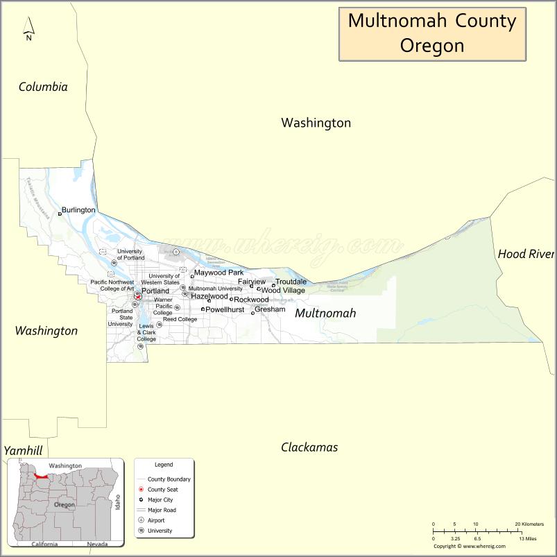
About Multnomah County Map, Oregon: The map showing the county boundary, county seat, major cities, highways, water bodies and neighbouring counties.
Oregon More Maps & Info
About Multnomah County, Oregon
Multnomah County is a county located in the U.S. state of Oregon. It's county seat is Portland. As per 2020 census, the population of Multnomah County is 803377 people and population density is square miles. According to the United States Census Bureau, the county has a total area of 435 sq mi (1,127 km2). Multnomah County was established on 1854.
Multnomah County Facts
| Continent | North America |
| Country | United States |
| State | Oregon |
| County Seat | Portland |
| Largest City/Town | Portland |
| Established | 1854 |
| Total Area | 466 sq mi (1,207 sq km) |
| Land Area | 431 sq mi (1,116 sq km) |
| Water Area | 35 sq mi (91 sq km) |
| Population | 815,428 (Census 2020) |
| Population Density | 1,891.9 people per sq mi |
| Time Zone | Pacific Time Zone |
| Major Highways | Interstate 5, Interstate 84, Interstate 205, U.S. Route 26 |
| Major Rivers | Willamette River, Columbia River, Sandy River |
| Neighboring Counties | Clackamas County, Washington County, Columbia County, Clark County (WA) |
| Famous For | Portland culture, bridges, parks, food scene, arts, and Pacific Northwest urban life |
| Top Attractions | Portland attractions, Columbia River Gorge nearby access, Washington Park, Powell's City of Books |
| Official Website | Official Website |
About Multnomah County, Oregon
Multnomah County is located in northwestern Oregon in the United States and was established in 1854. The county seat and largest city is Portland, the largest city in Oregon. The county is known for urban culture, scenic rivers, historic neighborhoods, parks, bridges, museums, and vibrant food and arts communities.
Cities and Towns in Multnomah County, Oregon
| City/Town | Population (Census 2020) | Latitude & Longitude |
|---|---|---|
| Portland (county seat) | 652,503 | 45.5152°N, 122.6784°W |
| Fairview | 10,424 | 45.5387°N, 122.4337°W |
| Gresham | 114,247 | 45.5001°N, 122.4302°W |
| Maywood Park | 829 | 45.5523°N, 122.5618°W |
| Troutdale | 16,300 | 45.5407°N, 122.3873°W |
| Wood Village | 4,224 | 45.5365°N, 122.4187°W |
| Corbett (CDP) | 3,890 | 45.5326°N, 122.2904°W |
| Dunthorpe (CDP) | 1,498 | 45.4432°N, 122.6834°W |
Golf Courses in Multnomah County, Oregon
| Golf Course | Location | Latitude & Longitude |
|---|---|---|
| Eastmoreland Golf Course | Portland | 45.4743°N, 122.6381°W |
| Heron Lakes Golf Club | Portland | 45.6055°N, 122.7168°W |
| Rose City Golf Course | Portland | 45.5417°N, 122.6037°W |
| Glendoveer Golf Course | Portland | 45.5268°N, 122.5049°W |
| Colwood Golf Center | Portland | 45.5691°N, 122.5798°W |
Roads and Highways in Multnomah County, Oregon
Major highways connect the county to nearby regions and cities.
- Interstate 5 - major north-south highway linking Portland with Seattle, Salem, and California
- Interstate 84 - connects Portland with the Columbia River Gorge and eastern Oregon
- Interstate 205 - bypass route serving eastern Portland metropolitan communities
- U.S. Route 26 - major route connecting Portland with the Oregon Coast and Mount Hood region
Neighboring Counties of Multnomah County
- Washington County (west)
- Clackamas County (south)
- Columbia County (northwest)
- Clark County, Washington (north)
Top Attractions in Multnomah County, Oregon
The county features several attractions known for history, culture, and recreation.
- Washington Park - large urban park featuring gardens, trails, and cultural institutions
- Powell's City of Books - world-famous independent bookstore in downtown Portland
- Portland Japanese Garden - acclaimed garden with traditional Japanese landscaping
- Oregon Museum of Science and Industry (OMSI) - interactive science museum on the Willamette River
- Pittock Mansion - historic estate overlooking Portland and the surrounding mountains
- Tom McCall Waterfront Park - riverfront recreation area along downtown Portland
- Lan Su Chinese Garden - classical Chinese garden and cultural attraction
- Columbia River Gorge nearby access - scenic waterfalls and hiking destinations east of Portland
Distance from Multnomah County to Nearby Cities
The following distances are measured by road (driving).
- Portland to Salem (Marion County), Oregon - 47 mi (76 km)
- Portland to Eugene (Lane County), Oregon - 110 mi (177 km)
- Portland to Hood River (Hood River County), Oregon - 62 mi (100 km)
- Portland to Astoria (Clatsop County), Oregon - 97 mi (156 km)
- Portland to Newport (Lincoln County), Oregon - 131 mi (211 km)
- Portland to Bend (Deschutes County), Oregon - 162 mi (261 km)
- Portland to Seattle (King County), Washington - 173 mi (278 km)
- Portland to Vancouver (Clark County), Washington - 10 mi (16 km)
- Portland to Medford (Jackson County), Oregon - 274 mi (441 km)
- Portland to Klamath Falls (Klamath County), Oregon - 282 mi (454 km)
- Portland to Boise (Ada County), Idaho - 428 mi (689 km)
- Portland to San Francisco (San Francisco County), California - 635 mi (1,022 km)
FAQs about Multnomah County
Multnomah County is located in northwestern Oregon along the Columbia and Willamette rivers.
Multnomah County had a population of 815,428 according to Census 2020 data.
Multnomah County is known for Portland culture, bridges, parks, arts, food, and Pacific Northwest urban attractions.
The county is served by Interstate 5, Interstate 84, Interstate 205, and U.S. Route 26.
Yes, Multnomah County has several golf facilities including Eastmoreland Golf Course and Heron Lakes Golf Club.
- Baker County Map
- Benton County Map
- Clackamas County Map
- Clatsop County Map
- Columbia County Map
- Coos County Map
- Crook County Map
- Curry County Map
- Deschutes County Map
- Douglas County Map
- Gilliam County Map
- Grant County Map
- Harney County Map
- Hood River County Map
- Jackson County Map
- Jefferson County Map
- Josephine County Map
- Klamath County Map
- Lake County Map
- Lane County Map
- Lincoln County Map
- Linn County Map
- Malheur County Map
- Marion County Map
- Morrow County Map
- Multnomah County Map
- Polk County Map
- Sherman County Map
- Tillamook County Map
- Umatilla County Map
- Union County Map
- Wallowa County Map
- Wasco County Map
- Washington County Map
- Wheeler County Map
- Yamhill County Map
- Alabama Counties
- Alaska boroughs
- Arizona Counties
- Arkansas Counties
- California County Map
- Colorado Counties
- Connecticut Counties
- Delaware Counties
- Florida County Map
- Georgia County Map
- Hawaii Counties
- Idaho Counties
- Illinois Counties
- Indiana Counties
- Iowa Counties
- Kansas Counties
- Kentucky Counties
- Louisiana Counties
- Maine Counties
- Maryland Counties
- Massachusetts Counties
- Michigan County Map
- Minnesota Counties
- Mississippi Counties
- Missouri Counties
- Montana Counties
- Nebraska Counties
- Nevada Counties
- New York Counties
- New Hampshire Counties
- New Jersey Counties
- New Mexico Counties
- North Carolina Counties
- North Dakota Counties
- Ohio County Map
- Oklahoma Counties
- Oregon Counties
- Pennsylvania Counties
- Rhode Island Counties
- South Carolina Counties
- South Dakota Counties
- Map of Tennessee
- Texas County Map
- Utah Counties
- Vermont Counties
- Virginia Counties
- Washington Counties
- West Virginia Counties
- Wisconsin Counties
- Wyoming Counties