Map of Jackson County - Jackson County is a county located in the U.S. state of Oregon. Jackson County Map showing cities, highways, important places and water bodies. Get Where is Jackson County located in the map, major cities in Jackson county, population, areas, and places of interest.
Map of Jackson County, Oregon
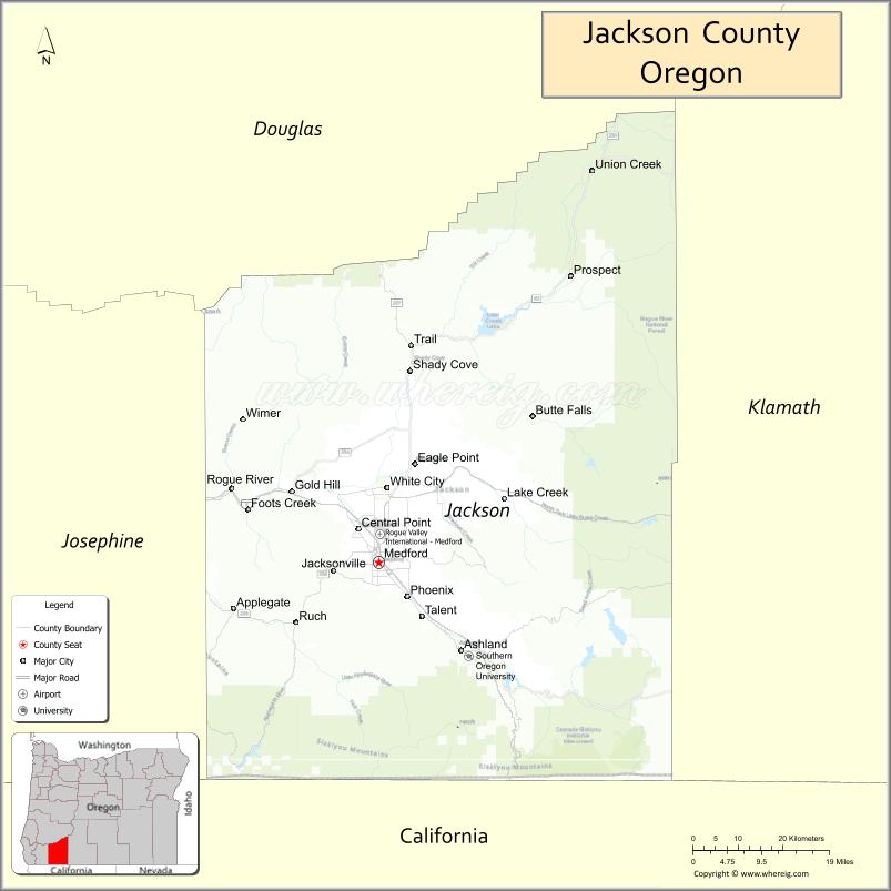
About Jackson County Map, Oregon: The map showing the county boundary, county seat, major cities, highways, water bodies and neighbouring counties.
Oregon More Maps & Info
About Jackson County, Oregon
Jackson County is a county located in the U.S. state of Oregon. It's county seat is Medford. As per 2020 census, the population of Jackson County is 223734 people and population density is square miles. According to the United States Census Bureau, the county has a total area of 2,785 sq mi (7,213 km2). Jackson County was established on 1852.
Jackson County Facts
| Continent | North America |
| Country | United States |
| State | Oregon |
| County Seat | Medford |
| Largest City/Town | Medford |
| Established | 1852 |
| Total Area | 2,802 sq mi (7,257 sq km) |
| Land Area | 2,784 sq mi (7,211 sq km) |
| Water Area | 18 sq mi (47 sq km) |
| Population | 223,259 (Census 2020) |
| Population Density | 80.2 people per sq mi |
| Time Zone | Pacific Time Zone |
| Major Highways | Interstate 5, U.S. Route 199, Oregon Route 62, Oregon Route 140 |
| Major Rivers | Rogue River, Applegate River, Bear Creek |
| Neighboring Counties | Josephine County, Douglas County, Klamath County, Siskiyou County (CA) |
| Famous For | Rogue Valley wineries, Crater Lake access, outdoor recreation, and Shakespeare culture |
| Top Attractions | Crater Lake nearby access, Oregon Shakespeare Festival, Rogue River, Table Rocks, Jacksonville Historic District |
| Official Website | Official Website |
About Jackson County, Oregon
Jackson County is located in southwestern Oregon in the United States and was established in 1852. The county seat and largest city is Medford. The county is known for the scenic Rogue Valley, vineyards, mountains, rivers, historic towns, and major cultural attractions that draw visitors throughout the year.
Cities and Towns in Jackson County, Oregon
| City/Town | Population (Census 2020) | Latitude & Longitude |
|---|---|---|
| Medford (county seat) | 85,824 | 42.3265°N, 122.8756°W |
| Ashland | 21,360 | 42.1946°N, 122.7095°W |
| Butte Falls | 451 | 42.5387°N, 122.5381°W |
| Central Point | 18,997 | 42.3751°N, 122.9164°W |
| Eagle Point | 9,686 | 42.4726°N, 122.8020°W |
| Gold Hill | 1,268 | 42.4318°N, 123.0506°W |
| Jacksonville | 3,020 | 42.3137°N, 123.0087°W |
| Phoenix | 4,809 | 42.2751°N, 122.8181°W |
| Rogue River | 2,407 | 42.4340°N, 123.1728°W |
| Shady Cove | 3,119 | 42.6115°N, 122.8120°W |
| Talent | 6,282 | 42.2457°N, 122.7886°W |
| White City (CDP) | 9,083 | 42.4376°N, 122.8581°W |
| Ruch (CDP) | 840 | 42.2334°N, 123.0494°W |
| Trail (CDP) | 702 | 42.6507°N, 122.8184°W |
Golf Courses in Jackson County, Oregon
| Golf Course | Location | Latitude & Longitude |
|---|---|---|
| Rogue Valley Country Club | Medford | 42.3398°N, 122.8437°W |
| Centennial Golf Club | Medford | 42.3921°N, 122.8683°W |
| Stone Ridge Golf Club | Eagle Point | 42.4772°N, 122.7976°W |
| Bear Creek Golf Course | Medford | 42.3520°N, 122.8711°W |
| Quail Point Golf Course | Medford | 42.2976°N, 122.9063°W |
| Oak Knoll Golf Course | Ashland | 42.1717°N, 122.6919°W |
| Eagle Point Golf Club | Eagle Point | 42.4739°N, 122.7960°W |
Roads and Highways in Jackson County, Oregon
Major highways connect the county to nearby regions and cities.
- Interstate 5 - major north-south route linking Medford with Eugene, Grants Pass, and California
- U.S. Route 199 - connects Jackson County with the Oregon Coast and Crescent City, California
- Oregon Route 62 - provides access to Crater Lake National Park and eastern mountain areas
- Oregon Route 140 - connects Medford with Klamath Falls and southern Oregon recreation regions
Neighboring Counties of Jackson County
- Douglas County (north)
- Josephine County (west)
- Klamath County (east)
- Siskiyou County, California (south)
Top Attractions in Jackson County, Oregon
The county features several attractions known for history, nature, and recreation.
- Oregon Shakespeare Festival - internationally recognized theater festival held in Ashland
- Rogue River - scenic river popular for rafting, fishing, and outdoor recreation
- Crater Lake nearby access - gateway route to Oregon's famous national park
- Jacksonville Historic District - preserved gold rush era town with shops and historic buildings
- Upper and Lower Table Rock - volcanic plateaus with hiking trails and panoramic valley views
- Applegate Valley Wineries - wine region known for vineyards and tasting rooms
- Lithia Park - scenic park in Ashland featuring gardens, trails, and natural springs
- Rogue Valley ZipLine Adventure - outdoor adventure attraction with mountain scenery
Distance from Jackson County to Nearby Cities
The following distances are measured by road (driving).
- Medford to Ashland (Jackson County), Oregon - 14 mi (23 km)
- Medford to Grants Pass (Josephine County), Oregon - 30 mi (48 km)
- Medford to Klamath Falls (Klamath County), Oregon - 78 mi (126 km)
- Medford to Roseburg (Douglas County), Oregon - 96 mi (154 km)
- Medford to Crescent City (Del Norte County), California - 106 mi (171 km)
- Medford to Redding (Shasta County), California - 150 mi (241 km)
- Medford to Eugene (Lane County), Oregon - 167 mi (269 km)
- Medford to Bend (Deschutes County), Oregon - 176 mi (283 km)
- Medford to Salem (Marion County), Oregon - 238 mi (383 km)
- Medford to Portland (Multnomah County), Oregon - 274 mi (441 km)
- Medford to Reno (Washoe County), Nevada - 332 mi (534 km)
- Medford to Sacramento (Sacramento County), California - 292 mi (470 km)
FAQs about Jackson County
Jackson County is located in southwestern Oregon near the California border.
Jackson County had a population of 223,259 according to Census 2020 data.
Jackson County is known for Rogue Valley wineries, outdoor recreation, historic towns, and the Oregon Shakespeare Festival.
The county is served by Interstate 5, U.S. Route 199, Oregon Route 62, and Oregon Route 140.
Yes, Jackson County has several golf facilities including Rogue Valley Country Club, Centennial Golf Club, and Oak Knoll Golf Course.
- Baker County Map
- Benton County Map
- Clackamas County Map
- Clatsop County Map
- Columbia County Map
- Coos County Map
- Crook County Map
- Curry County Map
- Deschutes County Map
- Douglas County Map
- Gilliam County Map
- Grant County Map
- Harney County Map
- Hood River County Map
- Jackson County Map
- Jefferson County Map
- Josephine County Map
- Klamath County Map
- Lake County Map
- Lane County Map
- Lincoln County Map
- Linn County Map
- Malheur County Map
- Marion County Map
- Morrow County Map
- Multnomah County Map
- Polk County Map
- Sherman County Map
- Tillamook County Map
- Umatilla County Map
- Union County Map
- Wallowa County Map
- Wasco County Map
- Washington County Map
- Wheeler County Map
- Yamhill County Map
- Alabama Counties
- Alaska boroughs
- Arizona Counties
- Arkansas Counties
- California County Map
- Colorado Counties
- Connecticut Counties
- Delaware Counties
- Florida County Map
- Georgia County Map
- Hawaii Counties
- Idaho Counties
- Illinois Counties
- Indiana Counties
- Iowa Counties
- Kansas Counties
- Kentucky Counties
- Louisiana Counties
- Maine Counties
- Maryland Counties
- Massachusetts Counties
- Michigan County Map
- Minnesota Counties
- Mississippi Counties
- Missouri Counties
- Montana Counties
- Nebraska Counties
- Nevada Counties
- New York Counties
- New Hampshire Counties
- New Jersey Counties
- New Mexico Counties
- North Carolina Counties
- North Dakota Counties
- Ohio County Map
- Oklahoma Counties
- Oregon Counties
- Pennsylvania Counties
- Rhode Island Counties
- South Carolina Counties
- South Dakota Counties
- Map of Tennessee
- Texas County Map
- Utah Counties
- Vermont Counties
- Virginia Counties
- Washington Counties
- West Virginia Counties
- Wisconsin Counties
- Wyoming Counties