Map of Clackamas County - Clackamas County is a county located in the U.S. state of Oregon. Clackamas County Map showing cities, highways, important places and water bodies. Get Where is Clackamas County located in the map, major cities in Clackamas county, population, areas, and places of interest.
Map of Clackamas County, Oregon
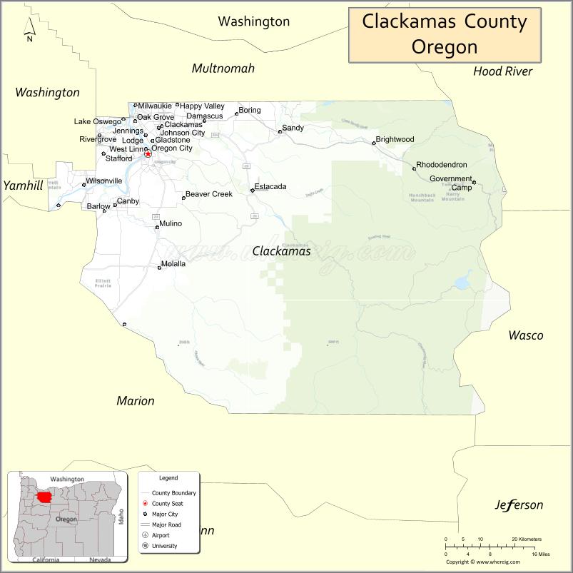
About Clackamas County Map, Oregon: The map showing the county boundary, county seat, major cities, highways, water bodies and neighbouring counties.
Oregon More Maps & Info
About Clackamas County, Oregon
Clackamas County is a county located in the U.S. state of Oregon. It's county seat is Oregon City. As per 2020 census, the population of Clackamas County is 422537 people and population density is square miles. According to the United States Census Bureau, the county has a total area of 1,868 sq mi (4,838 km2). Clackamas County was established on 1843.
Clackamas County Facts
| Continent | North America |
| Country | United States |
| State | Oregon |
| County Seat | Oregon City |
| Largest City/Town | Lake Oswego |
| Established | 1843 |
| Total Area | 1,883 sq mi (4,877 sq km) |
| Land Area | 1,870 sq mi (4,843 sq km) |
| Water Area | 13 sq mi (34 sq km) |
| Population | 421,401 (Census 2020) |
| Population Density | 225.3 people per sq mi |
| Time Zone | Pacific Time Zone |
| Major Highways | Interstate 205, Interstate 84, U.S. Route 26, Oregon Route 213, Oregon Route 224 |
| Major Rivers | Willamette River, Clackamas River, Sandy River, Molalla River |
| Neighboring Counties | Multnomah County, Hood River County, Wasco County, Marion County, Yamhill County, Washington County |
| Famous For | Mount Hood recreation, waterfalls, Oregon Trail history, and outdoor activities |
| Top Attractions | Mount Hood National Forest, Timberline Lodge, Willamette Falls, Clackamas River, Silver Falls nearby access |
| Official Website | Official Website |
About Clackamas County, Oregon
Clackamas County is located in the northwestern part of Oregon in the United States and was established in 1843. The county seat is Oregon City, while Lake Oswego is the largest city in the county. The county stretches from the Portland metropolitan area to the Cascade Mountains and includes forests, rivers, waterfalls, and major recreation areas around Mount Hood.
Cities and Towns in Clackamas County, Oregon
| City/Town | Population (Census 2020) | Latitude & Longitude |
|---|---|---|
| Oregon City (county seat) | 37,572 | 45.3573°N, 122.6068°W |
| Barlow | 141 | 45.2465°N, 122.6765°W |
| Canby | 18,171 | 45.2629°N, 122.6920°W |
| Damascus | 11,495 | 45.4165°N, 122.4581°W |
| Estacada | 5,247 | 45.2896°N, 122.3345°W |
| Gladstone | 12,017 | 45.3807°N, 122.5948°W |
| Happy Valley | 27,516 | 45.4465°N, 122.5306°W |
| Johnson City | 566 | 45.3734°N, 122.6126°W |
| Lake Oswego | 40,731 | 45.4207°N, 122.6706°W |
| Milwaukie | 21,119 | 45.4462°N, 122.6393°W |
| Molalla | 9,220 | 45.1473°N, 122.5770°W |
| Rivergrove | 545 | 45.3968°N, 122.7337°W |
| Sandy | 12,949 | 45.3973°N, 122.2612°W |
| Tualatin (partly in Clackamas County) | 27,942 | 45.3848°N, 122.7639°W |
| West Linn | 26,593 | 45.3657°N, 122.6123°W |
| Wilsonville (partly in Clackamas County) | 26,664 | 45.2998°N, 122.7737°W |
| Welches (CDP) | 1,034 | 45.3287°N, 121.9593°W |
Golf Courses in Clackamas County, Oregon
| Golf Course | Location | Latitude & Longitude |
|---|---|---|
| Oregon Golf Club | West Linn | 45.3317°N, 122.6928°W |
| Stone Creek Golf Club | Oregon City | 45.3070°N, 122.6129°W |
| Sah-Hah-Lee Golf Course | Clackamas | 45.3896°N, 122.4930°W |
| Charbonneau Golf Club | Wilsonville | 45.3045°N, 122.7584°W |
| Persimmon Country Club | Gresham | 45.4744°N, 122.3872°W |
| The Courses at Resort at the Mountain | Welches | 45.3319°N, 121.9625°W |
| Eastmoreland Golf Course | Milwaukie | 45.4704°N, 122.6374°W |
Roads and Highways in Clackamas County, Oregon
Major highways connect the county to nearby regions and cities.
- Interstate 205 - major north-south route linking the county with Portland and the Willamette Valley
- Interstate 84 - provides access to the Columbia River Gorge and eastern Oregon
- U.S. Route 26 - connects Portland with Sandy, Mount Hood, and central Oregon
- Oregon Route 213 - links Oregon City with Molalla and Silverton areas
- Oregon Route 224 - follows the Clackamas River corridor toward Mount Hood National Forest
Neighboring Counties of Clackamas County
- Multnomah County (north)
- Hood River County (northeast)
- Wasco County (east)
- Marion County (south)
- Yamhill County (west)
- Washington County (northwest)
Top Attractions in Clackamas County, Oregon
The county features several attractions known for history, nature, and recreation.
- Mount Hood National Forest - large recreation area with hiking, camping, and scenic mountain views
- Timberline Lodge - historic mountain lodge and popular skiing destination
- Willamette Falls - famous waterfall near downtown Oregon City
- Clackamas River - popular for rafting, fishing, and kayaking
- Bagby Hot Springs - natural hot springs located in a forested setting
- Silver Star Mountain viewpoints - scenic outdoor recreation areas near the Cascade foothills
- End of the Oregon Trail Interpretive Center - museum focused on pioneer history
- Mt. Hood Skibowl - winter sports and summer recreation destination
Distance from Clackamas County to Nearby Cities
The following distances are measured by road (driving).
- Oregon City to Portland (Multnomah County), Oregon - 13 mi (21 km)
- Oregon City to Salem (Marion County), Oregon - 43 mi (69 km)
- Oregon City to Vancouver (Clark County), Washington - 22 mi (35 km)
- Oregon City to Gresham (Multnomah County), Oregon - 17 mi (27 km)
- Oregon City to Hillsboro (Washington County), Oregon - 30 mi (48 km)
- Oregon City to Sandy (Clackamas County), Oregon - 23 mi (37 km)
- Oregon City to Hood River (Hood River County), Oregon - 63 mi (101 km)
- Oregon City to Eugene (Lane County), Oregon - 112 mi (180 km)
- Oregon City to Bend (Deschutes County), Oregon - 162 mi (261 km)
- Oregon City to Astoria (Clatsop County), Oregon - 117 mi (188 km)
- Oregon City to Newport (Lincoln County), Oregon - 112 mi (180 km)
- Oregon City to The Dalles (Wasco County), Oregon - 83 mi (134 km)
FAQs about Clackamas County
Clackamas County is located in northwestern Oregon and extends from the Portland metropolitan area to the Cascade Mountains.
Clackamas County had a population of 421,401 according to Census 2020 data.
Clackamas County is known for Mount Hood recreation, waterfalls, Oregon Trail history, and outdoor recreation opportunities.
The county is served by Interstate 205, Interstate 84, U.S. Route 26, Oregon Route 213, and Oregon Route 224.
Yes, Clackamas County has several golf facilities including Oregon Golf Club, Stone Creek Golf Club, and The Courses at Resort at the Mountain.
- Baker County Map
- Benton County Map
- Clackamas County Map
- Clatsop County Map
- Columbia County Map
- Coos County Map
- Crook County Map
- Curry County Map
- Deschutes County Map
- Douglas County Map
- Gilliam County Map
- Grant County Map
- Harney County Map
- Hood River County Map
- Jackson County Map
- Jefferson County Map
- Josephine County Map
- Klamath County Map
- Lake County Map
- Lane County Map
- Lincoln County Map
- Linn County Map
- Malheur County Map
- Marion County Map
- Morrow County Map
- Multnomah County Map
- Polk County Map
- Sherman County Map
- Tillamook County Map
- Umatilla County Map
- Union County Map
- Wallowa County Map
- Wasco County Map
- Washington County Map
- Wheeler County Map
- Yamhill County Map
- Alabama Counties
- Alaska boroughs
- Arizona Counties
- Arkansas Counties
- California County Map
- Colorado Counties
- Connecticut Counties
- Delaware Counties
- Florida County Map
- Georgia County Map
- Hawaii Counties
- Idaho Counties
- Illinois Counties
- Indiana Counties
- Iowa Counties
- Kansas Counties
- Kentucky Counties
- Louisiana Counties
- Maine Counties
- Maryland Counties
- Massachusetts Counties
- Michigan County Map
- Minnesota Counties
- Mississippi Counties
- Missouri Counties
- Montana Counties
- Nebraska Counties
- Nevada Counties
- New York Counties
- New Hampshire Counties
- New Jersey Counties
- New Mexico Counties
- North Carolina Counties
- North Dakota Counties
- Ohio County Map
- Oklahoma Counties
- Oregon Counties
- Pennsylvania Counties
- Rhode Island Counties
- South Carolina Counties
- South Dakota Counties
- Map of Tennessee
- Texas County Map
- Utah Counties
- Vermont Counties
- Virginia Counties
- Washington Counties
- West Virginia Counties
- Wisconsin Counties
- Wyoming Counties