Map of Crook County - Crook County is a county located in the U.S. state of Oregon. Crook County Map showing cities, highways, important places and water bodies. Get Where is Crook County located in the map, major cities in Crook county, population, areas, and places of interest.
Map of Crook County, Oregon
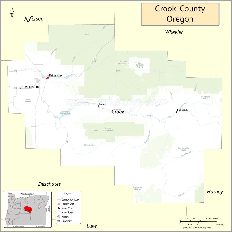
About Crook County Map, Oregon: The map showing the county boundary, county seat, major cities, highways, water bodies and neighbouring counties.
Oregon More Maps & Info
About Crook County, Oregon
Crook County is a county located in the U.S. state of Oregon. It's county seat is Prineville. As per 2020 census, the population of Crook County is 25739 people and population density is square miles. According to the United States Census Bureau, the county has a total area of 2,980 sq mi (7,718 km2). Crook County was established on 1882.
Crook County Facts
| Continent | North America |
| Country | United States |
| State | Oregon |
| County Seat | Prineville |
| Largest City/Town | Prineville |
| Established | 1882 |
| Total Area | 2,987 sq mi (7,736 sq km) |
| Land Area | 2,979 sq mi (7,715 sq km) |
| Water Area | 8 sq mi (21 sq km) |
| Population | 24,738 (Census 2020) |
| Population Density | 8.3 people per sq mi |
| Time Zone | Pacific Time Zone |
| Major Highways | U.S. Route 26, Oregon Route 27, Oregon Route 380 |
| Major Rivers | Crooked River, Deschutes River, North Fork Crooked River |
| Neighboring Counties | Jefferson County, Wheeler County, Grant County, Harney County, Deschutes County |
| Famous For | High desert landscapes, ranching, rock climbing, and scenic canyons |
| Top Attractions | Smith Rock State Park nearby access, Prineville Reservoir State Park, Crooked River Canyon, Ochoco National Forest |
| Official Website | Official Website |
About Crook County, Oregon
Crook County is located in central Oregon in the United States and was established in 1882. The county seat is Prineville, which is also the largest city in the county. The county is known for its high desert terrain, scenic river canyons, ranchlands, forests, and outdoor recreation opportunities across central Oregon.
Cities and Towns in Crook County, Oregon
| City/Town | Population (Census 2020) | Latitude & Longitude |
|---|---|---|
| Prineville (county seat) | 10,429 | 44.2999°N, 120.8345°W |
| Paulina | Not Incorporated | 44.1302°N, 119.6878°W |
| Post | Not Incorporated | 44.1091°N, 120.2555°W |
| Powell Butte (CDP) | 1,884 | 44.2443°N, 120.9831°W |
| Juniper Canyon (CDP) | 1,336 | 44.2875°N, 120.9036°W |
| Prineville Lake Acres (CDP) | 1,543 | 44.1447°N, 120.7561°W |
| Crooked River Ranch (partly in Crook County) | 5,699 | 44.4054°N, 121.2412°W |
Golf Courses in Crook County, Oregon
| Golf Course | Location | Latitude & Longitude |
|---|---|---|
| Meadow Lakes Golf Course | Prineville | 44.2984°N, 120.8648°W |
| Brasada Canyons Golf Club | Powell Butte | 44.1886°N, 121.0305°W |
| Pronghorn Club | Pronghorn Resort Area | 44.0925°N, 121.0804°W |
Roads and Highways in Crook County, Oregon
Major highways connect the county to nearby regions and cities.
- U.S. Route 26 - main east-west highway connecting Prineville with Bend, John Day, and eastern Oregon
- Oregon Route 27 - links Prineville with the Ochoco Reservoir and eastern ranching areas
- Oregon Route 380 - connects central Crook County with Post and Wheeler County communities
Neighboring Counties of Crook County
- Jefferson County (northwest)
- Wheeler County (east)
- Grant County (east)
- Harney County (south)
- Deschutes County (west)
Top Attractions in Crook County, Oregon
The county features several attractions known for history, nature, and recreation.
- Prineville Reservoir State Park - popular destination for boating, fishing, and camping
- Ochoco National Forest - forest recreation area with hiking, camping, and wildlife viewing
- Crooked River Canyon - scenic canyon known for rock formations and river views
- Smith Rock State Park nearby access - internationally known rock climbing destination near the county line
- Steins Pillar - dramatic volcanic rock formation with hiking opportunities
- Ochoco Creek Park - community recreation area in Prineville
- Crooked River Scenic Drive - route featuring high desert and canyon scenery
- Prineville Railway Depot Museum - local museum focused on regional rail and ranching history
Distance from Crook County to Nearby Cities
The following distances are measured by road (driving).
- Prineville to Bend (Deschutes County), Oregon - 36 mi (58 km)
- Prineville to Redmond (Deschutes County), Oregon - 20 mi (32 km)
- Prineville to Madras (Jefferson County), Oregon - 42 mi (68 km)
- Prineville to John Day (Grant County), Oregon - 122 mi (196 km)
- Prineville to Burns (Harney County), Oregon - 130 mi (209 km)
- Prineville to Eugene (Lane County), Oregon - 161 mi (259 km)
- Prineville to Salem (Marion County), Oregon - 147 mi (237 km)
- Prineville to Portland (Multnomah County), Oregon - 168 mi (270 km)
- Prineville to The Dalles (Wasco County), Oregon - 122 mi (196 km)
- Prineville to Newport (Lincoln County), Oregon - 179 mi (288 km)
- Prineville to Medford (Jackson County), Oregon - 228 mi (367 km)
- Prineville to Pendleton (Umatilla County), Oregon - 186 mi (299 km)
FAQs about Crook County
Crook County is located in central Oregon within the high desert region of the state.
Crook County had a population of 24,738 according to Census 2020 data.
Crook County is known for high desert scenery, ranching, rock climbing areas, scenic canyons, and outdoor recreation.
The county is served by U.S. Route 26, Oregon Route 27, and Oregon Route 380.
Yes, Crook County has several golf facilities including Meadow Lakes Golf Course and Brasada Canyons Golf Club.
- Baker County Map
- Benton County Map
- Clackamas County Map
- Clatsop County Map
- Columbia County Map
- Coos County Map
- Crook County Map
- Curry County Map
- Deschutes County Map
- Douglas County Map
- Gilliam County Map
- Grant County Map
- Harney County Map
- Hood River County Map
- Jackson County Map
- Jefferson County Map
- Josephine County Map
- Klamath County Map
- Lake County Map
- Lane County Map
- Lincoln County Map
- Linn County Map
- Malheur County Map
- Marion County Map
- Morrow County Map
- Multnomah County Map
- Polk County Map
- Sherman County Map
- Tillamook County Map
- Umatilla County Map
- Union County Map
- Wallowa County Map
- Wasco County Map
- Washington County Map
- Wheeler County Map
- Yamhill County Map
- Alabama Counties
- Alaska boroughs
- Arizona Counties
- Arkansas Counties
- California County Map
- Colorado Counties
- Connecticut Counties
- Delaware Counties
- Florida County Map
- Georgia County Map
- Hawaii Counties
- Idaho Counties
- Illinois Counties
- Indiana Counties
- Iowa Counties
- Kansas Counties
- Kentucky Counties
- Louisiana Counties
- Maine Counties
- Maryland Counties
- Massachusetts Counties
- Michigan County Map
- Minnesota Counties
- Mississippi Counties
- Missouri Counties
- Montana Counties
- Nebraska Counties
- Nevada Counties
- New York Counties
- New Hampshire Counties
- New Jersey Counties
- New Mexico Counties
- North Carolina Counties
- North Dakota Counties
- Ohio County Map
- Oklahoma Counties
- Oregon Counties
- Pennsylvania Counties
- Rhode Island Counties
- South Carolina Counties
- South Dakota Counties
- Map of Tennessee
- Texas County Map
- Utah Counties
- Vermont Counties
- Virginia Counties
- Washington Counties
- West Virginia Counties
- Wisconsin Counties
- Wyoming Counties