Map of Wheeler County - Wheeler County is a county located in the U.S. state of Oregon. Wheeler County Map showing cities, highways, important places and water bodies. Get Where is Wheeler County located in the map, major cities in Wheeler county, population, areas, and places of interest.
Map of Wheeler County, Oregon
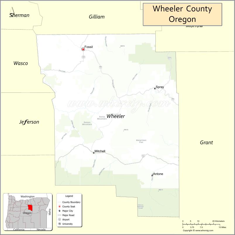
About Wheeler County Map, Oregon: The map showing the county boundary, county seat, major cities, highways, water bodies and neighbouring counties.
Oregon More Maps & Info
About Wheeler County, Oregon
Wheeler County is a county located in the U.S. state of Oregon. It's county seat is Fossil. As per 2020 census, the population of Wheeler County is 1451 people and population density is square miles. According to the United States Census Bureau, the county has a total area of 1,715 sq mi (4,442 km2). Wheeler County was established on 1899.
Wheeler County Facts
| Continent | North America |
| Country | United States |
| State | Oregon |
| County Seat | Fossil |
| Largest City/Town | Fossil |
| Established | 1899 |
| Total Area | 1,715 sq mi (4,442 sq km) |
| Land Area | 1,714 sq mi (4,439 sq km) |
| Water Area | 1 sq mi (3 sq km) |
| Population | 1,451 (Census 2020) |
| Population Density | 0.8 people per sq mi |
| Time Zone | Pacific Time Zone |
| Major Highways | Oregon Route 19, Oregon Route 26, Oregon Route 207 |
| Major Rivers | John Day River, Clarno River, Bridge Creek |
| Neighboring Counties | Gilliam County, Grant County, Crook County, Jefferson County, Sherman County, Morrow County |
| Famous For | Fossil beds, painted hills scenery, ranching, and remote high desert landscapes |
| Top Attractions | John Day Fossil Beds nearby access, Painted Hills nearby access, Fossil museum, scenic drives and ranchlands |
| Official Website | Official Website |
About Wheeler County, Oregon
Wheeler County is located in north-central Oregon in the United States and was established in 1899. The county seat and largest city is Fossil. The county is known for colorful geological formations, fossil discoveries, ranching heritage, remote landscapes, and scenic outdoor recreation in eastern Oregon.
Cities and Towns in Wheeler County, Oregon
| City/Town | Population (Census 2020) | Latitude & Longitude |
|---|---|---|
| Fossil (county seat) | 473 | 44.9993°N, 120.2167°W |
| Mitchell | 148 | 44.5660°N, 120.1525°W |
| Spray | 139 | 44.8318°N, 119.7950°W |
| Twickenham | 45 | 44.7921°N, 119.9815°W |
Golf Courses in Wheeler County, Oregon
| Golf Course | Location | Latitude & Longitude |
|---|---|---|
| Fossil Golf Course | Fossil | 45.0008°N, 120.2205°W |
| John Day Golf Club nearby access | John Day Area | 44.4168°N, 118.9520°W |
Roads and Highways in Wheeler County, Oregon
Major highways connect the county to nearby regions and scenic destinations.
- Oregon Route 19 - scenic highway connecting Fossil with the John Day River region and Columbia River routes
- Oregon Route 26 - east-west highway linking Mitchell and nearby high desert communities
- Oregon Route 207 - regional highway connecting rural ranching areas with northeastern Oregon
Neighboring Counties of Wheeler County
- Gilliam County (north)
- Morrow County (northeast)
- Grant County (east)
- Crook County (south)
- Jefferson County (southwest)
- Sherman County (west)
Top Attractions in Wheeler County, Oregon
The county features several attractions known for geology, scenery, and outdoor recreation.
- John Day Fossil Beds National Monument nearby access - famous fossil and geological formations
- Painted Hills nearby access - colorful layered hills and one of Oregon’s most photographed landscapes
- Wheeler High School Fossil Beds - public fossil digging site in Fossil
- Clarno Unit nearby access - dramatic rock formations and hiking trails
- John Day River Recreation Areas - rafting, fishing, and scenic canyon landscapes
- Fossil Museum - local museum preserving regional paleontology and pioneer history
- Journey Through Time Scenic Byway - scenic driving route through eastern Oregon landscapes
- Mitchell Rock Climbing Areas - outdoor recreation and desert canyon scenery
Distance from Wheeler County to Nearby Cities
The following distances are measured by road (driving).
- Fossil to Condon (Gilliam County), Oregon - 38 mi (61 km)
- Fossil to John Day (Grant County), Oregon - 82 mi (132 km)
- Fossil to Bend (Deschutes County), Oregon - 116 mi (187 km)
- Fossil to Pendleton (Umatilla County), Oregon - 133 mi (214 km)
- Fossil to The Dalles (Wasco County), Oregon - 97 mi (156 km)
- Fossil to Madras (Jefferson County), Oregon - 90 mi (145 km)
- Fossil to Portland (Multnomah County), Oregon - 167 mi (269 km)
- Fossil to Salem (Marion County), Oregon - 212 mi (341 km)
- Fossil to Boise (Ada County), Idaho - 291 mi (468 km)
- Fossil to Eugene (Lane County), Oregon - 219 mi (352 km)
- Fossil to Medford (Jackson County), Oregon - 285 mi (459 km)
- Fossil to Astoria (Clatsop County), Oregon - 264 mi (425 km)
FAQs about Wheeler County
Wheeler County is located in north-central Oregon in the high desert and canyon region.
Wheeler County had a population of 1,451 according to Census 2020 data.
Wheeler County is known for fossil beds, Painted Hills scenery, ranching heritage, and remote desert landscapes.
The county is served by Oregon Route 19, Oregon Route 26, and Oregon Route 207.
Yes, Wheeler County has golf facilities including Fossil Golf Course near Fossil.
- Baker County Map
- Benton County Map
- Clackamas County Map
- Clatsop County Map
- Columbia County Map
- Coos County Map
- Crook County Map
- Curry County Map
- Deschutes County Map
- Douglas County Map
- Gilliam County Map
- Grant County Map
- Harney County Map
- Hood River County Map
- Jackson County Map
- Jefferson County Map
- Josephine County Map
- Klamath County Map
- Lake County Map
- Lane County Map
- Lincoln County Map
- Linn County Map
- Malheur County Map
- Marion County Map
- Morrow County Map
- Multnomah County Map
- Polk County Map
- Sherman County Map
- Tillamook County Map
- Umatilla County Map
- Union County Map
- Wallowa County Map
- Wasco County Map
- Washington County Map
- Wheeler County Map
- Yamhill County Map
- Alabama Counties
- Alaska boroughs
- Arizona Counties
- Arkansas Counties
- California County Map
- Colorado Counties
- Connecticut Counties
- Delaware Counties
- Florida County Map
- Georgia County Map
- Hawaii Counties
- Idaho Counties
- Illinois Counties
- Indiana Counties
- Iowa Counties
- Kansas Counties
- Kentucky Counties
- Louisiana Counties
- Maine Counties
- Maryland Counties
- Massachusetts Counties
- Michigan County Map
- Minnesota Counties
- Mississippi Counties
- Missouri Counties
- Montana Counties
- Nebraska Counties
- Nevada Counties
- New York Counties
- New Hampshire Counties
- New Jersey Counties
- New Mexico Counties
- North Carolina Counties
- North Dakota Counties
- Ohio County Map
- Oklahoma Counties
- Oregon Counties
- Pennsylvania Counties
- Rhode Island Counties
- South Carolina Counties
- South Dakota Counties
- Map of Tennessee
- Texas County Map
- Utah Counties
- Vermont Counties
- Virginia Counties
- Washington Counties
- West Virginia Counties
- Wisconsin Counties
- Wyoming Counties