Map of Baker County - Baker County is a county located in the U.S. state of Oregon. Baker County Map showing cities, highways, important places and water bodies. Get Where is Baker County located in the map, major cities in Baker county, population, areas, and places of interest.
Map of Baker County, Oregon
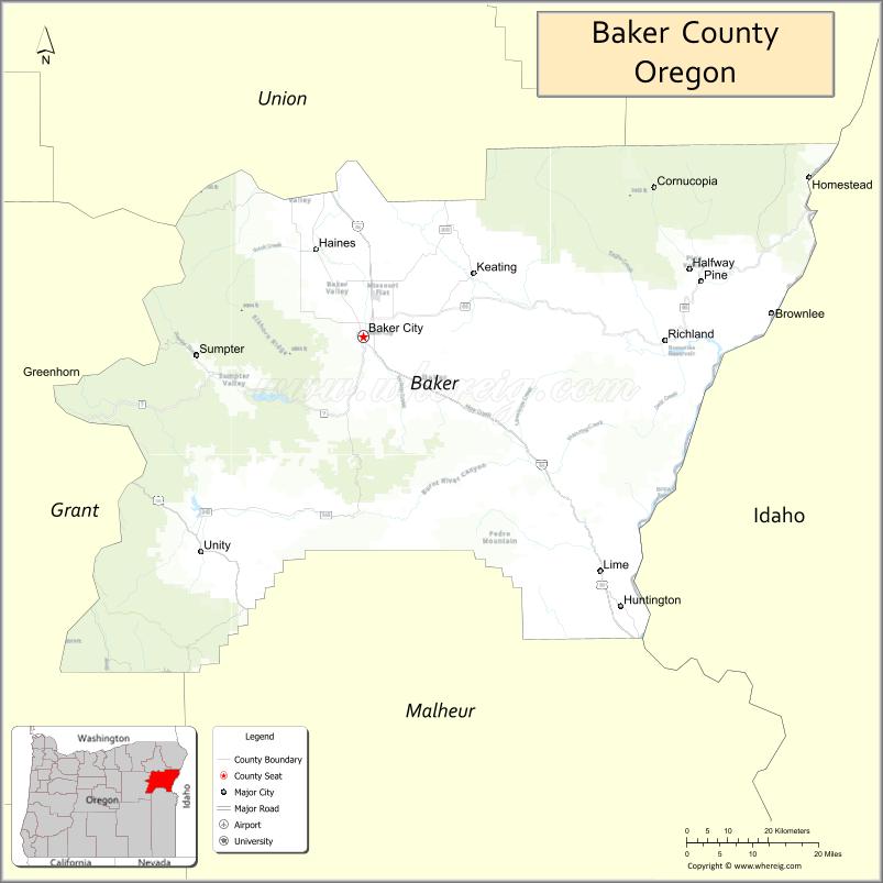
About Baker County Map, Oregon: The map showing the county boundary, county seat, major cities, highways, water bodies and neighbouring counties.
Oregon More Maps & Info
About Baker County, Oregon
Baker County is a county located in the U.S. state of Oregon. It's county seat is Baker City. As per 2020 census, the population of Baker County is 16847 people and population density is square miles. According to the United States Census Bureau, the county has a total area of 3,068 sq mi (7,946 km2). Baker County was established on 1862.
Baker County Facts
| Continent | North America |
| Country | United States |
| State | Oregon |
| County Seat | Baker City |
| Largest City/Town | Baker City |
| Established | 1862 |
| Total Area | 3,088 sq mi (7,998 sq km) |
| Land Area | 3,068 sq mi (7,946 sq km) |
| Water Area | 20 sq mi (52 sq km) |
| Population | 16,756 (Census 2020) |
| Population Density | 5.5 people per sq mi |
| Time Zone | Pacific Time Zone |
| Major Highways | Interstate 84, U.S. Route 26, Oregon Route 7, Oregon Route 86 |
| Major Rivers | Powder River, Burnt River, Snake River |
| Neighboring Counties | Union County, Wallowa County, Grant County, Malheur County |
| Famous For | Oregon Trail history, gold mining heritage, mountain scenery, and outdoor recreation |
| Top Attractions | National Historic Oregon Trail Interpretive Center, Anthony Lakes Mountain Resort, Sumpter Valley Railroad, Hells Canyon Scenic Byway |
| Official Website | Official Website |
About Baker County, Oregon
Baker County is located in the northeastern part of Oregon in the United States and was established in 1862. The county seat is Baker City, which is also the largest city in the county. The county is known for its mountains, forests, rivers, and historic Oregon Trail sites that reflect its important role in western expansion and mining history.
Cities and Towns in Baker County, Oregon
| City/Town | Population (Census 2020) | Latitude & Longitude |
|---|---|---|
| Baker City (county seat) | 10,133 | 44.7749°N, 117.8344°W |
| Halfway | 288 | 44.8807°N, 117.1127°W |
| Haines | 416 | 44.9123°N, 117.9363°W |
| Huntington | 502 | 44.3518°N, 117.2677°W |
| Richland | 165 | 44.7746°N, 117.1727°W |
| Sumpter | 204 | 44.7457°N, 118.1991°W |
| Unity | 77 | 44.4343°N, 118.1869°W |
| Keating (CDP) | 62 | 44.7835°N, 117.8970°W |
Golf Courses in Baker County, Oregon
| Golf Course | Location | Latitude & Longitude |
|---|---|---|
| Quail Ridge Golf Course | Baker City | 44.7606°N, 117.8217°W |
| Pine Valley Golf Club | Halfway | 44.8801°N, 117.1120°W |
Roads and Highways in Baker County, Oregon
Major highways connect the county to nearby regions and cities.
- Interstate 84 - runs through Baker City and connects the county with Pendleton, La Grande, and Boise, Idaho
- U.S. Route 26 - links Baker County with John Day and central Oregon communities
- Oregon Route 7 - connects Baker City with Sumpter and Austin Junction
- Oregon Route 86 - provides access to Richland, Halfway, and Hells Canyon areas
Neighboring Counties of Baker County
- Union County (north)
- Wallowa County (northeast)
- Washington County, Idaho (east)
- Malheur County (south)
- Grant County (west)
Top Attractions in Baker County, Oregon
The county features several attractions known for history, nature, and recreation.
- National Historic Oregon Trail Interpretive Center - interactive museum and trails focused on pioneer history
- Anthony Lakes Mountain Resort - skiing and snowboarding destination in the Elkhorn Mountains
- Sumpter Valley Railroad - historic narrow-gauge railroad offering scenic train rides
- Geiser Grand Hotel - beautifully restored historic hotel in downtown Baker City
- Hells Canyon Scenic Byway - scenic driving route with mountain and canyon views
- Baker Heritage Museum - local museum featuring mining, ranching, and pioneer exhibits
- Phillips Reservoir - popular recreation area for boating, fishing, and camping
- Elkhorn Mountains - hiking and wildlife viewing destination with alpine scenery
Distance from Baker County to Nearby Cities
The following distances are measured by road (driving).
- Baker City to La Grande (Union County), Oregon - 44 mi (71 km)
- Baker City to Ontario (Malheur County), Oregon - 73 mi (117 km)
- Baker City to Pendleton (Umatilla County), Oregon - 128 mi (206 km)
- Baker City to John Day (Grant County), Oregon - 122 mi (196 km)
- Baker City to Burns (Harney County), Oregon - 131 mi (211 km)
- Baker City to Boise (Ada County), Idaho - 128 mi (206 km)
- Baker City to Caldwell (Canyon County), Idaho - 115 mi (185 km)
- Baker City to Nampa (Canyon County), Idaho - 121 mi (195 km)
- Baker City to Walla Walla (Walla Walla County), Washington - 155 mi (249 km)
- Baker City to Hermiston (Umatilla County), Oregon - 155 mi (249 km)
- Baker City to Bend (Deschutes County), Oregon - 252 mi (406 km)
- Baker City to Yakima (Yakima County), Washington - 245 mi (394 km)
FAQs about Baker County
Baker County is located in northeastern Oregon near the Idaho border.
Baker County had a population of 16,756 according to Census 2020 data.
Baker County is known for Oregon Trail history, mountain scenery, gold mining heritage, and outdoor recreation opportunities.
The county is served by Interstate 84, U.S. Route 26, Oregon Route 7, and Oregon Route 86.
Yes, Baker County has golf facilities including Quail Ridge Golf Course in Baker City and Pine Valley Golf Club in Halfway.
- Baker County Map
- Benton County Map
- Clackamas County Map
- Clatsop County Map
- Columbia County Map
- Coos County Map
- Crook County Map
- Curry County Map
- Deschutes County Map
- Douglas County Map
- Gilliam County Map
- Grant County Map
- Harney County Map
- Hood River County Map
- Jackson County Map
- Jefferson County Map
- Josephine County Map
- Klamath County Map
- Lake County Map
- Lane County Map
- Lincoln County Map
- Linn County Map
- Malheur County Map
- Marion County Map
- Morrow County Map
- Multnomah County Map
- Polk County Map
- Sherman County Map
- Tillamook County Map
- Umatilla County Map
- Union County Map
- Wallowa County Map
- Wasco County Map
- Washington County Map
- Wheeler County Map
- Yamhill County Map
- Alabama Counties
- Alaska boroughs
- Arizona Counties
- Arkansas Counties
- California County Map
- Colorado Counties
- Connecticut Counties
- Delaware Counties
- Florida County Map
- Georgia County Map
- Hawaii Counties
- Idaho Counties
- Illinois Counties
- Indiana Counties
- Iowa Counties
- Kansas Counties
- Kentucky Counties
- Louisiana Counties
- Maine Counties
- Maryland Counties
- Massachusetts Counties
- Michigan County Map
- Minnesota Counties
- Mississippi Counties
- Missouri Counties
- Montana Counties
- Nebraska Counties
- Nevada Counties
- New York Counties
- New Hampshire Counties
- New Jersey Counties
- New Mexico Counties
- North Carolina Counties
- North Dakota Counties
- Ohio County Map
- Oklahoma Counties
- Oregon Counties
- Pennsylvania Counties
- Rhode Island Counties
- South Carolina Counties
- South Dakota Counties
- Map of Tennessee
- Texas County Map
- Utah Counties
- Vermont Counties
- Virginia Counties
- Washington Counties
- West Virginia Counties
- Wisconsin Counties
- Wyoming Counties