Map of Linn County - Linn County is a county located in the U.S. state of Oregon. Linn County Map showing cities, highways, important places and water bodies. Get Where is Linn County located in the map, major cities in Linn county, population, areas, and places of interest.
Map of Linn County, Oregon
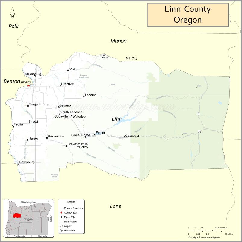
About Linn County Map, Oregon: The map showing the county boundary, county seat, major cities, highways, water bodies and neighbouring counties.
Oregon More Maps & Info
About Linn County, Oregon
Linn County is a county located in the U.S. state of Oregon. It's county seat is Albany. As per 2020 census, the population of Linn County is 129839 people and population density is square miles. According to the United States Census Bureau, the county has a total area of 2,291 sq mi (5,934 km2). Linn County was established on 1847.
Linn County Facts
| Continent | North America |
| Country | United States |
| State | Oregon |
| County Seat | Albany |
| Largest City/Town | Albany |
| Established | 1847 |
| Total Area | 2,309 sq mi (5,980 sq km) |
| Land Area | 2,290 sq mi (5,931 sq km) |
| Water Area | 19 sq mi (49 sq km) |
| Population | 128,610 (Census 2020) |
| Population Density | 56.2 people per sq mi |
| Time Zone | Pacific Time Zone |
| Major Highways | Interstate 5, U.S. Route 20, Oregon Route 34, Oregon Route 22 |
| Major Rivers | Willamette River, Santiam River, Calapooia River |
| Neighboring Counties | Marion County, Benton County, Lane County, Deschutes County, Jefferson County |
| Famous For | Willamette Valley agriculture, covered bridges, forests, and outdoor recreation |
| Top Attractions | Covered bridges, Cascade Mountain recreation, Willamette Valley scenery, historic Albany districts |
| Official Website | Official Website |
About Linn County, Oregon
Linn County is located in western Oregon in the United States and was established in 1847. The county seat and largest city is Albany. The county stretches from the fertile Willamette Valley eastward into the Cascade Mountains and is known for agriculture, forests, rivers, scenic covered bridges, and outdoor recreation areas.
Cities and Towns in Linn County, Oregon
| City/Town | Population (Census 2020) | Latitude & Longitude |
|---|---|---|
| Albany (county seat) | 56,472 | 44.6365°N, 123.1059°W |
| Brownsville | 1,689 | 44.3937°N, 122.9848°W |
| Cascadia | 78 | 44.3965°N, 122.4701°W |
| Crabtree | 1,541 | 44.6282°N, 122.9095°W |
| Halsey | 1,010 | 44.3854°N, 123.1090°W |
| Harrisburg (partly in Linn County) | 3,828 | 44.2743°N, 123.1718°W |
| Lebanon | 18,447 | 44.5365°N, 122.9070°W |
| Lyons | 1,228 | 44.7740°N, 122.6154°W |
| Mill City (partly in Linn County) | 1,926 | 44.7540°N, 122.4781°W |
| Scio | 956 | 44.7045°N, 122.8484°W |
| Sweet Home | 9,828 | 44.3993°N, 122.7362°W |
| Tangent | 1,198 | 44.5390°N, 123.1087°W |
| Waterloo | 203 | 44.4960°N, 122.8234°W |
Golf Courses in Linn County, Oregon
| Golf Course | Location | Latitude & Longitude |
|---|---|---|
| Spring Hill Golf Club | Albany | 44.6250°N, 123.1282°W |
| Mallard Creek Golf Course | Lebanon | 44.5408°N, 122.8947°W |
| Trysting Tree Golf Club nearby access | Corvallis Area | 44.5648°N, 123.2792°W |
| Pineway Golf Course | Lebanon | 44.5531°N, 122.9144°W |
Roads and Highways in Linn County, Oregon
Major highways connect the county to nearby regions and cities.
- Interstate 5 - major north-south highway connecting Albany with Salem, Eugene, and Portland
- U.S. Route 20 - east-west route linking Albany and Lebanon with central Oregon and the Oregon Coast
- Oregon Route 34 - connects Linn County with Corvallis and western Oregon communities
- Oregon Route 22 - scenic route leading toward the Cascade Mountains and central Oregon
Neighboring Counties of Linn County
- Marion County (north)
- Benton County (west)
- Lane County (southwest)
- Deschutes County (east)
- Jefferson County (east)
Top Attractions in Linn County, Oregon
The county features several attractions known for history, nature, and recreation.
- Historic Downtown Albany - preserved historic district with Victorian architecture and museums
- Covered Bridges Scenic Route - collection of historic covered bridges throughout rural Linn County
- Foster Lake - recreation area known for boating, fishing, and camping
- Green Peter Reservoir - scenic mountain reservoir popular for water recreation
- Willamette Valley Vineyards nearby access - wine tasting and agricultural tourism region
- McDowell Creek Falls County Park - waterfall hiking destination near Lebanon
- Soda Creek Falls - scenic waterfall in the Cascade foothills
- Cascadia State Park - riverside recreation area with forested picnic and camping sites
Distance from Linn County to Nearby Cities
The following distances are measured by road (driving).
- Albany to Corvallis (Benton County), Oregon - 11 mi (18 km)
- Albany to Salem (Marion County), Oregon - 26 mi (42 km)
- Albany to Eugene (Lane County), Oregon - 44 mi (71 km)
- Albany to Newport (Lincoln County), Oregon - 74 mi (119 km)
- Albany to Bend (Deschutes County), Oregon - 124 mi (200 km)
- Albany to Portland (Multnomah County), Oregon - 69 mi (111 km)
- Albany to Medford (Jackson County), Oregon - 188 mi (303 km)
- Albany to Florence (Lane County), Oregon - 96 mi (154 km)
- Albany to Hood River (Hood River County), Oregon - 126 mi (203 km)
- Albany to Astoria (Clatsop County), Oregon - 144 mi (232 km)
- Albany to Klamath Falls (Klamath County), Oregon - 207 mi (333 km)
- Albany to Coos Bay (Coos County), Oregon - 132 mi (212 km)
FAQs about Linn County
Linn County is located in western Oregon and stretches from the Willamette Valley into the Cascade Mountains.
Linn County had a population of 128,610 according to Census 2020 data.
Linn County is known for agriculture, covered bridges, forests, and scenic outdoor recreation areas.
The county is served by Interstate 5, U.S. Route 20, Oregon Route 34, and Oregon Route 22.
Yes, Linn County has golf facilities including Spring Hill Golf Club and Mallard Creek Golf Course.
- Baker County Map
- Benton County Map
- Clackamas County Map
- Clatsop County Map
- Columbia County Map
- Coos County Map
- Crook County Map
- Curry County Map
- Deschutes County Map
- Douglas County Map
- Gilliam County Map
- Grant County Map
- Harney County Map
- Hood River County Map
- Jackson County Map
- Jefferson County Map
- Josephine County Map
- Klamath County Map
- Lake County Map
- Lane County Map
- Lincoln County Map
- Linn County Map
- Malheur County Map
- Marion County Map
- Morrow County Map
- Multnomah County Map
- Polk County Map
- Sherman County Map
- Tillamook County Map
- Umatilla County Map
- Union County Map
- Wallowa County Map
- Wasco County Map
- Washington County Map
- Wheeler County Map
- Yamhill County Map
- Alabama Counties
- Alaska boroughs
- Arizona Counties
- Arkansas Counties
- California County Map
- Colorado Counties
- Connecticut Counties
- Delaware Counties
- Florida County Map
- Georgia County Map
- Hawaii Counties
- Idaho Counties
- Illinois Counties
- Indiana Counties
- Iowa Counties
- Kansas Counties
- Kentucky Counties
- Louisiana Counties
- Maine Counties
- Maryland Counties
- Massachusetts Counties
- Michigan County Map
- Minnesota Counties
- Mississippi Counties
- Missouri Counties
- Montana Counties
- Nebraska Counties
- Nevada Counties
- New York Counties
- New Hampshire Counties
- New Jersey Counties
- New Mexico Counties
- North Carolina Counties
- North Dakota Counties
- Ohio County Map
- Oklahoma Counties
- Oregon Counties
- Pennsylvania Counties
- Rhode Island Counties
- South Carolina Counties
- South Dakota Counties
- Map of Tennessee
- Texas County Map
- Utah Counties
- Vermont Counties
- Virginia Counties
- Washington Counties
- West Virginia Counties
- Wisconsin Counties
- Wyoming Counties