Map of Morrow County - Morrow County is a county located in the U.S. state of Oregon. Morrow County Map showing cities, highways, important places and water bodies. Get Where is Morrow County located in the map, major cities in Morrow county, population, areas, and places of interest.
Map of Morrow County, Oregon
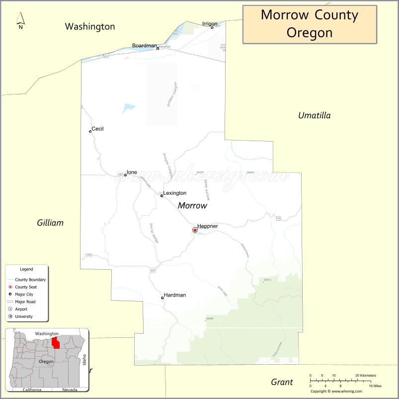
About Morrow County Map, Oregon: The map showing the county boundary, county seat, major cities, highways, water bodies and neighbouring counties.
Oregon More Maps & Info
About Morrow County, Oregon
Morrow County is a county located in the U.S. state of Oregon. It's county seat is Heppner. As per 2020 census, the population of Morrow County is 12303 people and population density is square miles. According to the United States Census Bureau, the county has a total area of 2,033 sq mi (5,265 km2). Morrow County was established on 1885.
Morrow County Facts
| Continent | North America |
| Country | United States |
| State | Oregon |
| County Seat | Heppner |
| Largest City/Town | Boardman |
| Established | 1885 |
| Total Area | 2,049 sq mi (5,307 sq km) |
| Land Area | 2,032 sq mi (5,264 sq km) |
| Water Area | 17 sq mi (44 sq km) |
| Population | 12,186 (Census 2020) |
| Population Density | 6.0 people per sq mi |
| Time Zone | Pacific Time Zone |
| Major Highways | Interstate 84, U.S. Route 730, Oregon Route 74, Oregon Route 207 |
| Major Rivers | Columbia River, Umatilla River, John Day River |
| Neighboring Counties | Gilliam County, Grant County, Umatilla County, Wheeler County |
| Famous For | Columbia River agriculture, wind energy, wheat farming, and outdoor recreation |
| Top Attractions | Columbia River recreation, Boardman Marina, Heppner heritage sites, scenic wheat country drives |
| Official Website | Official Website |
About Morrow County, Oregon
Morrow County is located in northeastern Oregon in the United States and was established in 1885. The county seat is Heppner, while Boardman is the largest city in the county. The county is known for wheat farming, Columbia River recreation, ranching communities, renewable energy projects, and scenic rolling landscapes across the Columbia Plateau.
Cities and Towns in Morrow County, Oregon
| City/Town | Population (Census 2020) | Latitude & Longitude |
|---|---|---|
| Heppner (county seat) | 1,291 | 45.3535°N, 119.5570°W |
| Boardman | 4,828 | 45.8393°N, 119.7003°W |
| Ione | 329 | 45.5057°N, 119.8223°W |
| Irrigon | 2,070 | 45.8954°N, 119.4911°W |
| Lexington | 238 | 45.4523°N, 119.6875°W |
| Hardman | 120 | 45.2474°N, 119.5422°W |
Golf Courses in Morrow County, Oregon
| Golf Course | Location | Latitude & Longitude |
|---|---|---|
| Willow Creek Country Club | Heppner | 45.3475°N, 119.5639°W |
| Big River Golf Course | Boardman | 45.8427°N, 119.6992°W |
Roads and Highways in Morrow County, Oregon
Major highways connect the county to nearby regions and cities.
- Interstate 84 - major east-west highway connecting Boardman with Pendleton, The Dalles, and Portland
- U.S. Route 730 - highway linking Irrigon and Columbia River communities with Umatilla and Washington State
- Oregon Route 74 - scenic route connecting Heppner with eastern Oregon farming communities
- Oregon Route 207 - connects Heppner with Interstate 84 and nearby rural areas
Neighboring Counties of Morrow County
- Gilliam County (west)
- Umatilla County (east)
- Grant County (south)
- Wheeler County (southwest)
Top Attractions in Morrow County, Oregon
The county features several attractions known for history, nature, and recreation.
- Boardman Marina Park - Columbia River recreation area with boating and camping facilities
- Willow Creek Reservoir - fishing and outdoor recreation destination near Heppner
- Heppner Historical Museum - museum featuring pioneer, ranching, and farming history
- Columbia River Recreation Areas - scenic waterfront destinations for fishing and boating
- Scenic Wheat Country Drives - rolling hills and seasonal agricultural landscapes
- Anson Wright Park - campground and recreation area near Heppner
- Morrow County OHV Park - off-road recreation area for outdoor enthusiasts
- Lewis and Clark Trail nearby access - historic route associated with early western exploration
Distance from Morrow County to Nearby Cities
The following distances are measured by road (driving).
- Heppner to Pendleton (Umatilla County), Oregon - 45 mi (72 km)
- Boardman to Hermiston (Umatilla County), Oregon - 25 mi (40 km)
- Heppner to Condon (Gilliam County), Oregon - 71 mi (114 km)
- Boardman to The Dalles (Wasco County), Oregon - 98 mi (158 km)
- Heppner to John Day (Grant County), Oregon - 109 mi (175 km)
- Boardman to Portland (Multnomah County), Oregon - 173 mi (278 km)
- Boardman to Salem (Marion County), Oregon - 187 mi (301 km)
- Heppner to Bend (Deschutes County), Oregon - 145 mi (233 km)
- Boardman to Boise (Ada County), Idaho - 287 mi (462 km)
- Heppner to La Grande (Union County), Oregon - 109 mi (175 km)
- Boardman to Hood River (Hood River County), Oregon - 119 mi (191 km)
- Heppner to Burns (Harney County), Oregon - 168 mi (270 km)
FAQs about Morrow County
Morrow County is located in northeastern Oregon along the Columbia Plateau region.
Morrow County had a population of 12,186 according to Census 2020 data.
Morrow County is known for wheat farming, Columbia River recreation, wind energy projects, and scenic rural landscapes.
The county is served by Interstate 84, U.S. Route 730, Oregon Route 74, and Oregon Route 207.
Yes, Morrow County has golf facilities including Willow Creek Country Club and Big River Golf Course.
- Baker County Map
- Benton County Map
- Clackamas County Map
- Clatsop County Map
- Columbia County Map
- Coos County Map
- Crook County Map
- Curry County Map
- Deschutes County Map
- Douglas County Map
- Gilliam County Map
- Grant County Map
- Harney County Map
- Hood River County Map
- Jackson County Map
- Jefferson County Map
- Josephine County Map
- Klamath County Map
- Lake County Map
- Lane County Map
- Lincoln County Map
- Linn County Map
- Malheur County Map
- Marion County Map
- Morrow County Map
- Multnomah County Map
- Polk County Map
- Sherman County Map
- Tillamook County Map
- Umatilla County Map
- Union County Map
- Wallowa County Map
- Wasco County Map
- Washington County Map
- Wheeler County Map
- Yamhill County Map
- Alabama Counties
- Alaska boroughs
- Arizona Counties
- Arkansas Counties
- California County Map
- Colorado Counties
- Connecticut Counties
- Delaware Counties
- Florida County Map
- Georgia County Map
- Hawaii Counties
- Idaho Counties
- Illinois Counties
- Indiana Counties
- Iowa Counties
- Kansas Counties
- Kentucky Counties
- Louisiana Counties
- Maine Counties
- Maryland Counties
- Massachusetts Counties
- Michigan County Map
- Minnesota Counties
- Mississippi Counties
- Missouri Counties
- Montana Counties
- Nebraska Counties
- Nevada Counties
- New York Counties
- New Hampshire Counties
- New Jersey Counties
- New Mexico Counties
- North Carolina Counties
- North Dakota Counties
- Ohio County Map
- Oklahoma Counties
- Oregon Counties
- Pennsylvania Counties
- Rhode Island Counties
- South Carolina Counties
- South Dakota Counties
- Map of Tennessee
- Texas County Map
- Utah Counties
- Vermont Counties
- Virginia Counties
- Washington Counties
- West Virginia Counties
- Wisconsin Counties
- Wyoming Counties