Map of Washington County - Washington County is a county located in the U.S. state of Oregon. Washington County Map showing cities, highways, important places and water bodies. Get Where is Washington County located in the map, major cities in Washington county, population, areas, and places of interest.
Map of Washington County, Oregon
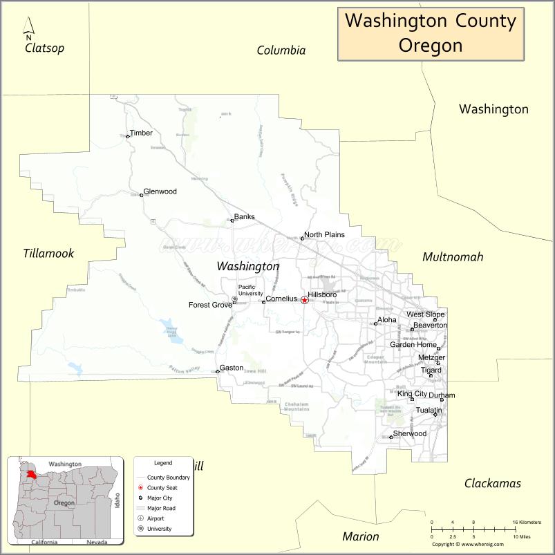
About Washington County Map, Oregon: The map showing the county boundary, county seat, major cities, highways, water bodies and neighbouring counties.
Oregon More Maps & Info
About Washington County, Oregon
Washington County is a county located in the U.S. state of Oregon. It's county seat is Hillsboro. As per 2020 census, the population of Washington County is 600811 people and population density is square miles. According to the United States Census Bureau, the county has a total area of 724 sq mi (1,875 km2). Washington County was established on 1843.
Washington County Facts
| Continent | North America |
| Country | United States |
| State | Oregon |
| County Seat | Hillsboro |
| Largest City/Town | Hillsboro |
| Established | 1843 |
| Total Area | 726 sq mi (1,880 sq km) |
| Land Area | 724 sq mi (1,875 sq km) |
| Water Area | 2 sq mi (5 sq km) |
| Population | 600,372 (Census 2020) |
| Population Density | 829.2 people per sq mi |
| Time Zone | Pacific Time Zone |
| Major Highways | U.S. Route 26, Oregon Route 8, Oregon Route 10, Interstate 5 nearby access |
| Major Rivers | Tualatin River, Willamette River nearby access |
| Neighboring Counties | Multnomah County, Clackamas County, Columbia County, Yamhill County, Tillamook County |
| Famous For | Silicon Forest technology industry, vineyards, parks, and suburban Portland communities |
| Top Attractions | Washington Park nearby access, wine country, Intel campuses, Tualatin Valley recreation, museums and gardens |
| Official Website | Official Website |
About Washington County, Oregon
Washington County is located in northwestern Oregon in the United States and was established in 1843. The county seat and largest city is Hillsboro. The county is known for technology industries, vineyards, parks, suburban communities, and economic growth within the Portland metropolitan region.
Cities and Towns in Washington County, Oregon
| City/Town | Population (Census 2020) | Latitude & Longitude |
|---|---|---|
| Hillsboro (county seat) | 106,447 | 45.5229°N, 122.9898°W |
| Beaverton | 97,494 | 45.4871°N, 122.8037°W |
| Cornelius | 12,706 | 45.5198°N, 123.0595°W |
| Durham | 1,668 | 45.4018°N, 122.7534°W |
| Forest Grove | 26,225 | 45.5196°N, 123.1107°W |
| Gaston | 681 | 45.4362°N, 123.1379°W |
| King City | 4,860 | 45.4021°N, 122.8012°W |
| North Plains | 3,424 | 45.5979°N, 122.9893°W |
| Sherwood | 20,450 | 45.3565°N, 122.8408°W |
| Tigard | 54,539 | 45.4312°N, 122.7715°W |
| Tualatin (partly in Washington County) | 27,942 | 45.3848°N, 122.7632°W |
| Banks | 1,839 | 45.6184°N, 123.1143°W |
| Wilsonville (partly in Washington County) | 26,664 | 45.2998°N, 122.7737°W |
Golf Courses in Washington County, Oregon
| Golf Course | Location | Latitude & Longitude |
|---|---|---|
| Pumpkin Ridge Golf Club | North Plains | 45.6264°N, 123.0141°W |
| The Reserve Vineyards & Golf Club | Aloha | 45.5055°N, 122.9103°W |
| RedTail Golf Center | Beaverton | 45.4722°N, 122.8438°W |
| Forest Hills Golf Course | Cornelius | 45.5165°N, 123.0452°W |
| Chehalem Glenn Golf Course nearby access | Newberg Area | 45.2937°N, 122.9680°W |
Roads and Highways in Washington County, Oregon
Major highways connect the county to nearby regions and metropolitan areas.
- U.S. Route 26 - major highway linking Portland with Hillsboro, the Oregon Coast, and western Oregon
- Oregon Route 8 - regional highway serving Hillsboro, Forest Grove, and agricultural communities
- Oregon Route 10 - connects Beaverton and Tigard with Portland metropolitan areas
- Interstate 5 nearby access - major interstate connecting the Portland region with Washington and California
Neighboring Counties of Washington County
- Multnomah County (east)
- Clackamas County (south)
- Yamhill County (southwest)
- Tillamook County (west)
- Columbia County (north)
Top Attractions in Washington County, Oregon
The county features several attractions known for culture, recreation, and technology.
- Silicon Forest Technology Corridor - major technology and semiconductor industry hub
- Rice Northwest Museum of Rocks and Minerals - museum featuring gemstones and natural history exhibits
- Tualatin Hills Nature Park - urban nature preserve with walking trails and wildlife viewing
- Cooper Mountain Nature Park - scenic park with hiking trails and panoramic valley views
- Willamette Valley Wine Country nearby access - vineyards and wine tasting destinations
- Roloff Farms - seasonal attraction known from television and family events
- Jackson Bottom Wetlands Preserve - environmental education and birdwatching area
- Hillsboro Downtown District - shopping, restaurants, cultural events, and historic architecture
Distance from Washington County to Nearby Cities
The following distances are measured by road (driving).
- Hillsboro to Portland (Multnomah County), Oregon - 19 mi (31 km)
- Hillsboro to Salem (Marion County), Oregon - 47 mi (76 km)
- Hillsboro to Eugene (Lane County), Oregon - 108 mi (174 km)
- Hillsboro to Astoria (Clatsop County), Oregon - 89 mi (143 km)
- Hillsboro to Tillamook (Tillamook County), Oregon - 73 mi (117 km)
- Hillsboro to Newport (Lincoln County), Oregon - 118 mi (190 km)
- Hillsboro to Hood River (Hood River County), Oregon - 82 mi (132 km)
- Hillsboro to Bend (Deschutes County), Oregon - 166 mi (267 km)
- Hillsboro to Medford (Jackson County), Oregon - 272 mi (438 km)
- Hillsboro to Seattle (King County), Washington - 176 mi (283 km)
- Hillsboro to Boise (Ada County), Idaho - 446 mi (718 km)
- Hillsboro to San Francisco (San Francisco County), California - 647 mi (1,041 km)
FAQs about Washington County
Washington County is located in northwestern Oregon within the Portland metropolitan region.
Washington County had a population of 600,372 according to Census 2020 data.
Washington County is known for the Silicon Forest technology industry, vineyards, parks, and suburban communities.
The county is served by U.S. Route 26, Oregon Route 8, Oregon Route 10, and nearby Interstate 5 access.
Yes, Washington County has several golf facilities including Pumpkin Ridge Golf Club and The Reserve Vineyards & Golf Club.
- Baker County Map
- Benton County Map
- Clackamas County Map
- Clatsop County Map
- Columbia County Map
- Coos County Map
- Crook County Map
- Curry County Map
- Deschutes County Map
- Douglas County Map
- Gilliam County Map
- Grant County Map
- Harney County Map
- Hood River County Map
- Jackson County Map
- Jefferson County Map
- Josephine County Map
- Klamath County Map
- Lake County Map
- Lane County Map
- Lincoln County Map
- Linn County Map
- Malheur County Map
- Marion County Map
- Morrow County Map
- Multnomah County Map
- Polk County Map
- Sherman County Map
- Tillamook County Map
- Umatilla County Map
- Union County Map
- Wallowa County Map
- Wasco County Map
- Washington County Map
- Wheeler County Map
- Yamhill County Map
- Alabama Counties
- Alaska boroughs
- Arizona Counties
- Arkansas Counties
- California County Map
- Colorado Counties
- Connecticut Counties
- Delaware Counties
- Florida County Map
- Georgia County Map
- Hawaii Counties
- Idaho Counties
- Illinois Counties
- Indiana Counties
- Iowa Counties
- Kansas Counties
- Kentucky Counties
- Louisiana Counties
- Maine Counties
- Maryland Counties
- Massachusetts Counties
- Michigan County Map
- Minnesota Counties
- Mississippi Counties
- Missouri Counties
- Montana Counties
- Nebraska Counties
- Nevada Counties
- New York Counties
- New Hampshire Counties
- New Jersey Counties
- New Mexico Counties
- North Carolina Counties
- North Dakota Counties
- Ohio County Map
- Oklahoma Counties
- Oregon Counties
- Pennsylvania Counties
- Rhode Island Counties
- South Carolina Counties
- South Dakota Counties
- Map of Tennessee
- Texas County Map
- Utah Counties
- Vermont Counties
- Virginia Counties
- Washington Counties
- West Virginia Counties
- Wisconsin Counties
- Wyoming Counties