Map of Union County - Union County is a county located in the U.S. state of Oregon. Union County Map showing cities, highways, important places and water bodies. Get Where is Union County located in the map, major cities in Union county, population, areas, and places of interest.
Map of Union County, Oregon
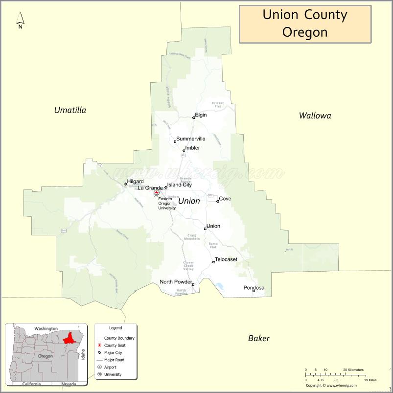
About Union County Map, Oregon: The map showing the county boundary, county seat, major cities, highways, water bodies and neighbouring counties.
Oregon More Maps & Info
About Union County, Oregon
Union County is a county located in the U.S. state of Oregon. It's county seat is La Grande. As per 2020 census, the population of Union County is 26212 people and population density is square miles. According to the United States Census Bureau, the county has a total area of 2,037 sq mi (5,276 km2). Union County was established on 1864.
Union County Facts
| Continent | North America |
| Country | United States |
| State | Oregon |
| County Seat | La Grande |
| Largest City/Town | La Grande |
| Established | 1864 |
| Total Area | 2,038 sq mi (5,278 sq km) |
| Land Area | 2,037 sq mi (5,275 sq km) |
| Water Area | 1 sq mi (3 sq km) |
| Population | 26,196 (Census 2020) |
| Population Density | 12.9 people per sq mi |
| Time Zone | Pacific Time Zone |
| Major Highways | Interstate 84, U.S. Route 30, Oregon Route 82, Oregon Route 237 |
| Major Rivers | Grande Ronde River, Catherine Creek, Wallowa River nearby access |
| Neighboring Counties | Umatilla County, Baker County, Wallowa County, Grant County |
| Famous For | Blue Mountains scenery, Eastern Oregon University, ranching, and outdoor recreation |
| Top Attractions | Blue Mountains, Grande Ronde Valley, Anthony Lakes nearby access, historic La Grande |
| Official Website | Official Website |
About Union County, Oregon
Union County is located in northeastern Oregon in the United States and was established in 1864. The county seat and largest city is La Grande. The county is known for mountain scenery, ranching heritage, outdoor recreation, university culture, and scenic valleys surrounded by the Blue Mountains.
Cities and Towns in Union County, Oregon
| City/Town | Population (Census 2020) | Latitude & Longitude |
|---|---|---|
| La Grande (county seat) | 13,333 | 45.3247°N, 118.0870°W |
| Cove | 552 | 45.2962°N, 117.8060°W |
| Elgin | 1,711 | 45.5654°N, 117.9174°W |
| Imbler | 310 | 45.4585°N, 117.9641°W |
| Island City | 1,144 | 45.3407°N, 118.0433°W |
| North Powder | 439 | 45.0257°N, 117.9208°W |
| Summerville | 135 | 45.5206°N, 117.7910°W |
| Union | 2,050 | 45.2082°N, 117.8652°W |
Golf Courses in Union County, Oregon
| Golf Course | Location | Latitude & Longitude |
|---|---|---|
| Buffalo Peak Golf Course | Union | 45.2068°N, 117.8729°W |
| La Grande Country Club | La Grande | 45.3218°N, 118.1026°W |
| Alpine Meadows Golf Course | Island City | 45.3382°N, 118.0381°W |
Roads and Highways in Union County, Oregon
Major highways connect the county to nearby regions and cities.
- Interstate 84 - major east-west highway connecting La Grande with Pendleton, Baker City, and Idaho
- U.S. Route 30 - historic route serving communities across northeastern Oregon
- Oregon Route 82 - scenic highway connecting La Grande with the Wallowa Valley and Joseph
- Oregon Route 237 - regional route linking Union County communities with rural ranching areas
Neighboring Counties of Union County
- Umatilla County (west)
- Grant County (southwest)
- Baker County (south)
- Wallowa County (east)
Top Attractions in Union County, Oregon
The county features several attractions known for history, scenery, and recreation.
- Eastern Oregon University - public university campus located in La Grande
- Grande Ronde Valley - scenic valley surrounded by mountain ranges and ranchland
- Blue Mountains - outdoor recreation destination for hiking, camping, and skiing
- Hot Lake Springs - historic hot springs and lodging attraction near La Grande
- Union County Museum - exhibits covering pioneer, railroad, and ranching history
- Anthony Lakes Mountain Resort nearby access - skiing and mountain recreation area
- Morgan Lake - hiking, fishing, and camping destination near La Grande
- Elgin Opera House - historic performing arts venue in downtown Elgin
Distance from Union County to Nearby Cities
The following distances are measured by road (driving).
- La Grande to Pendleton (Umatilla County), Oregon - 53 mi (85 km)
- La Grande to Baker City (Baker County), Oregon - 43 mi (69 km)
- La Grande to Enterprise (Wallowa County), Oregon - 69 mi (111 km)
- La Grande to John Day (Grant County), Oregon - 131 mi (211 km)
- La Grande to Boise (Ada County), Idaho - 170 mi (274 km)
- La Grande to Hermiston (Umatilla County), Oregon - 82 mi (132 km)
- La Grande to Bend (Deschutes County), Oregon - 231 mi (372 km)
- La Grande to Portland (Multnomah County), Oregon - 260 mi (418 km)
- La Grande to Spokane (Spokane County), Washington - 191 mi (307 km)
- La Grande to Salem (Marion County), Oregon - 274 mi (441 km)
- La Grande to Seattle (King County), Washington - 328 mi (528 km)
- La Grande to Medford (Jackson County), Oregon - 323 mi (520 km)
FAQs about Union County
Union County is located in northeastern Oregon in the Grande Ronde Valley region.
Union County had a population of 26,196 according to Census 2020 data.
Union County is known for Blue Mountains scenery, ranching heritage, outdoor recreation, and Eastern Oregon University.
The county is served by Interstate 84, U.S. Route 30, Oregon Route 82, and Oregon Route 237.
Yes, Union County has golf facilities including Buffalo Peak Golf Course and La Grande Country Club.
- Baker County Map
- Benton County Map
- Clackamas County Map
- Clatsop County Map
- Columbia County Map
- Coos County Map
- Crook County Map
- Curry County Map
- Deschutes County Map
- Douglas County Map
- Gilliam County Map
- Grant County Map
- Harney County Map
- Hood River County Map
- Jackson County Map
- Jefferson County Map
- Josephine County Map
- Klamath County Map
- Lake County Map
- Lane County Map
- Lincoln County Map
- Linn County Map
- Malheur County Map
- Marion County Map
- Morrow County Map
- Multnomah County Map
- Polk County Map
- Sherman County Map
- Tillamook County Map
- Umatilla County Map
- Union County Map
- Wallowa County Map
- Wasco County Map
- Washington County Map
- Wheeler County Map
- Yamhill County Map
- Alabama Counties
- Alaska boroughs
- Arizona Counties
- Arkansas Counties
- California County Map
- Colorado Counties
- Connecticut Counties
- Delaware Counties
- Florida County Map
- Georgia County Map
- Hawaii Counties
- Idaho Counties
- Illinois Counties
- Indiana Counties
- Iowa Counties
- Kansas Counties
- Kentucky Counties
- Louisiana Counties
- Maine Counties
- Maryland Counties
- Massachusetts Counties
- Michigan County Map
- Minnesota Counties
- Mississippi Counties
- Missouri Counties
- Montana Counties
- Nebraska Counties
- Nevada Counties
- New York Counties
- New Hampshire Counties
- New Jersey Counties
- New Mexico Counties
- North Carolina Counties
- North Dakota Counties
- Ohio County Map
- Oklahoma Counties
- Oregon Counties
- Pennsylvania Counties
- Rhode Island Counties
- South Carolina Counties
- South Dakota Counties
- Map of Tennessee
- Texas County Map
- Utah Counties
- Vermont Counties
- Virginia Counties
- Washington Counties
- West Virginia Counties
- Wisconsin Counties
- Wyoming Counties