By Whereig Editors, Reviewed by Mukesh Kumar| Updated On: May 02, 2026 | 20:16 ET
Map of St. Joseph County - St. Joseph County is a county located in the U.S. state of Indiana. St. Joseph County Map showing cities, highways, important places and water bodies. Get Where is St. Joseph County located in the map, major cities in St. Joseph county, population, areas, and places of interest.
Map of St Joseph County, Indiana
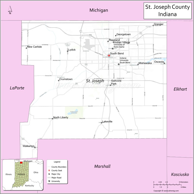
About St. Joseph County Map, Alabama: The map showing the county boundary, county seat, major cities, highways, water bodies and neighbouring counties.
Related Indiana Maps
About St Joseph County, Indiana
Switzerland County is a county located in the U.S. state of Indiana. It`s county seat is Vevay. As per 2020 census, the population of Switzerland County was 9790 and population density of Switzerland was square miles. According to the United States Census Bureau, the county has a total area of 221 sq mi (572 km2). Switzerland County was established on -31136.
St. Joseph County Facts
| Continent | North America |
| Country | United States |
| State | Indiana |
| County Seat | South Bend |
| Largest City/Town | South Bend |
| Established | 1830 |
| Total Area | 461 sq mi |
| Land Area | 457 sq mi |
| Water Area | 3.9 sq mi |
| Population | 272,912 (Census 2020) |
| Population Density | 597 people per sq mi |
| Time Zone | Eastern Time Zone (ET) |
| Major Highways | I-80, I-90, US-20, US-31, IN-2, IN-23 |
| Neighboring Counties | Berrien County, MI (north), Elkhart County (east), Marshall County (south), Starke County (southwest), LaPorte County (west) |
| Famous For | University of Notre Dame, South Bend, St. Joseph River |
| Top Attractions | University of Notre Dame, Studebaker National Museum, Potawatomi Zoo |
| Official Website | https://www.sjcindiana.com/ |
Cities and Towns in St. Joseph County, Indiana
- South Bend (county seat) – 103,453 (Census 2020)
- Mishawaka – 51,063 (Census 2020)
- Osceola – 2,463 (Census 2020)
- Lakeville – 875 (Census 2020)
- New Carlisle – 1,785 (Census 2020)
- Walkerton – 2,019 (Census 2020)
- North Liberty – 1,870 (Census 2020)
- Roseland – 637 (Census 2020)
Roads and Highways in St. Joseph County, Indiana
St. Joseph County is a major transportation hub in northern Indiana with access to interstate highways and regional routes.
- Interstate 80/90 (I-80/I-90) – Indiana Toll Road connecting Chicago to Ohio
- US Route 20 – east-west highway linking South Bend to Michigan and Illinois
- US Route 31 – north-south route connecting South Bend to Indianapolis
- Indiana State Road 2 – connects the county to LaPorte and Elkhart
- Indiana State Road 23 – runs through South Bend linking to Michigan
Neighboring Counties of St. Joseph County
- Berrien County, Michigan (north)
- Elkhart County (east)
- Marshall County (south)
- Starke County (southwest)
- LaPorte County (west)
Top Attractions in St. Joseph County, Indiana
St. Joseph County offers cultural attractions, education, and outdoor recreation.
- University of Notre Dame – historic campus and cultural landmark
- Studebaker National Museum – exhibits on automotive history
- Potawatomi Zoo – one of the oldest zoos in Indiana
- St. Joseph River – scenic river running through South Bend
- Mishawaka Riverwalk – walking paths and scenic views
- South Bend Downtown – dining, shopping, and entertainment
Distance from St. Joseph County to Nearby Cities
- St. Joseph County to Chicago – 90 mi (145 km)
- St. Joseph County to Fort Wayne – 80 mi (129 km)
- St. Joseph County to Indianapolis – 150 mi (241 km)
- St. Joseph County to Detroit – 200 mi (322 km)
- St. Joseph County to Grand Rapids – 120 mi (193 km)
FAQs about St. Joseph County
St. Joseph County is located in northern Indiana along the Michigan border.
The county seat is South Bend, which is also the largest city in the county.
It is known for the University of Notre Dame, South Bend, and the St. Joseph River.
Yes, it is part of the South Bend–Mishawaka metropolitan area.
The county is served by I-80, I-90, US-20, US-31, and several Indiana state roads.
- Adams County Map, IN
- Allen County Map, IN
- Bartholomew County Map, IN
- Benton County Map, IN
- Blackford County Map, IN
- Boone County Map, IN
- Brown County Map, IN
- Carroll County Map, IN
- Cass County Map, IN
- Clark County Map, IN
- Clay County Map, IN
- Clinton County Map, IN
- Crawford County Map, IN
- Daviess County Map, IN
- Dearborn County Map, IN
- Decatur County Map, IN
- DeKalb County Map, IN
- Delaware County Map, IN
- Dubois County Map, IN
- Elkhart County Map, IN
- Fayette County Map, IN
- Floyd County Map, IN
- Fountain County Map, IN
- Franklin County Map, IN
- Fulton County Map, IN
- Gibson County Map, IN
- Grant County Map, IN
- Greene County Map, IN
- Hamilton County Map, IN
- Hancock County Map, IN
- Harrison County Map, IN
- Hendricks County Map, IN
- Henry County Map, IN
- Howard County Map, IN
- Huntington County Map, IN
- Jackson County Map, IN
- Jasper County Map, IN
- Jay County Map, IN
- Jefferson County Map, IN
- Jennings County Map, IN
- Johnson County Map, IN
- Knox County Map, IN
- Kosciusko County Map, IN
- LaGrange County Map, IN
- Lake County Map, IN
- LaPorte County Map, IN
- Lawrence County Map, IN
- Madison County Map, IN
- Marion County Map, IN
- Marshall County Map, IN
- Martin County Map, IN
- Miami County Map, IN
- Monroe County Map, IN
- Montgomery County Map, IN
- Morgan County Map, IN
- Newton County Map, IN
- Noble County Map, IN
- Ohio County Map, IN
- Orange County Map, IN
- Owen County Map, IN
- Parke County Map, IN
- Perry County Map, IN
- Pike County Map, IN
- Porter County Map, IN
- Posey County Map, IN
- Pulaski County Map, IN
- Putnam County Map, IN
- Randolph County Map, IN
- Ripley County Map, IN
- Rush County Map, IN
- St Joseph County Map, IN
- Scott County Map, IN
- Shelby County Map, IN
- Spencer County Map, IN
- Starke County Map, IN
- Steuben County Map, IN
- Sullivan County Map, IN
- Switzerland County Map, IN
- Tippecanoe County Map, IN
- Tipton County Map, IN
- Union County Map, IN
- Vanderburgh County Map, IN
- Vermillion County Map, IN
- Vigo County Map, IN
- Wabash County Map, IN
- Warren County Map, IN
- Warrick County Map, IN
- Washington County Map, IN
- Wayne County Map, IN
- Wells County Map, IN
- White County Map, IN
- Whitley County Map, IN
- Alabama Counties
- Alaska boroughs
- Arizona Counties
- Arkansas Counties
- California County Map
- Colorado Counties
- Connecticut Counties
- Delaware Counties
- Florida County Map
- Georgia County Map
- Hawaii Counties
- Idaho Counties
- Illinois Counties
- Indiana Counties
- Iowa Counties
- Kansas Counties
- Kentucky Counties
- Louisiana Counties
- Maine Counties
- Maryland Counties
- Massachusetts Counties
- Michigan County Map
- Minnesota Counties
- Mississippi Counties
- Missouri Counties
- Montana Counties
- Nebraska Counties
- Nevada Counties
- New York Counties
- New Hampshire Counties
- New Jersey Counties
- New Mexico Counties
- North Carolina Counties
- North Dakota Counties
- Ohio County Map
- Oklahoma Counties
- Oregon Counties
- Pennsylvania Counties
- Rhode Island Counties
- South Carolina Counties
- South Dakota Counties
- Map of Tennessee
- Texas County Map
- Utah Counties
- Vermont Counties
- Virginia Counties
- Washington Counties
- West Virginia Counties
- Wisconsin Counties
- Wyoming Counties