Map of Franklin County - Franklin County is a county located in the U.S. state of Iowa. Franklin County Map showing cities, highways, important places and water bodies. Get Where is Franklin County located in the map, major cities in Franklin county, population, areas, and places of interest.
Franklin County Map, Iowa
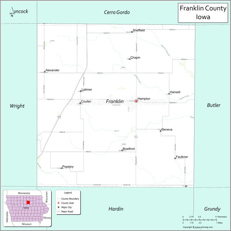
About Franklin County Map, Iowa: The map showing the county boundary, county seat, major cities, highways, water bodies and neighbouring counties.
More Iowa Maps & Info
| Iowa Map | Iowa County Map | Iowa Cities Map |
| Iowa Zip codes | Where is Iowa | Airports in Iowa |
| Iowa Area Codes | Iowa Blank Map | Iowa River Map |
| Iowa Physical Map | Iowa Road Map | Where is Des Moines |
Map of Franklin County, Iowa
Franklin County is a county located in the U.S. state of Iowa. It's county seat is Hampton. As per 2020 census, the population of Franklin County is 9952 people and population density is square miles. According to the United States Census Bureau, the county has a total area of 582 sq mi (1,507 km2). Franklin County was established on -17881.
Franklin County Facts
| County Info | Facts |
|---|---|
| County | Franklin County |
| County Seat | Hampton |
| State | Iowa |
| Country | United States |
| FIPS code | 69 |
| Established | -17881 |
| Area | 582 sq mi (1,507 km2) |
| Population | 9952 |
| Density | |
| Formed / Origin | Chickasaw County |
Ctities in Franklin county
| City Name | Type | Population (2020) | Pop. Density | Area | Incorporated |
|---|---|---|---|---|---|
| Alexander | 164 | 4.27 sq mi (11.1 km2) | March 25, 1902 | ||
| Coulter | 2.45 sq mi (6.3 km2) | April 24, 1909 | |||
| Geneva | 0.42 sq mi (1.1 km2) | April 7, 1903 | |||
| Hampton | 4.43 sq mi (11.5 km2) | November 19, 1870 | |||
| Hansell | 0.23 sq mi (0.6 km2) | May 7, 1918 | |||
| Latimer | 2.4 sq mi (6.2 km2) | April 17, 1901 | |||
| Popejoy | 0.74 sq mi (1.9 km2) | July 24, 1908 | |||
| Sheffield | 5.55 sq mi (14.4 km2) | April 8, 1876 | |||
| Ackley | 1,599 | 2.45 sq mi (6.3 km2) | August 28, 1869 | ||
| Dows | 0.77 sq mi (2 km2) | May 3, 1892 |
Places to Visit in Franklin
Top places to visit in london includes Christian Herschler Winery, Wilson Lake Park, Wilson Lake, Pollmiller Park.
Highways in Franklin
Interstate 35, U.S. Highway 65, Iowa Highway 3, Iowa Highway 57.
Nearest Airports
Nearest airport of Franklin is Waterloo Regional Airport (ALO / KALO).
- Adair County Map
- Adams County Map
- Allamakee County Map
- Appanoose County Map
- Audubon County Map
- Benton County Map
- Black Hawk County Map
- Boone County Map
- Bremer County Map
- Buchanan County Map
- Buena Vista County Map
- Butler County Map
- Calhoun County Map
- Carroll County Map
- Cass County Map
- Cedar County Map
- Cerro Gordo County Map
- Cherokee County Map
- Chickasaw County Map
- Clarke County Map
- Clay County Map
- Clayton County Map
- Clinton County Map
- Crawford County Map
- Dallas County Map
- Davis County Map
- Decatur County Map
- Delaware County Map
- Des Moines County Map
- Dickinson County Map
- Dubuque County Map
- Emmet County Map
- Fayette County Map
- Floyd County Map
- Franklin County Map
- Fremont County Map
- Greene County Map
- Grundy County Map
- Guthrie County Map
- Hamilton County Map
- Hancock County Map
- Hardin County Map
- Harrison County Map
- Henry County Map
- Howard County Map
- Humboldt County Map
- Ida County Map
- Iowa County Map
- Jackson County Map
- Jasper County Map
- Jefferson County Map
- Johnson County Map
- Jones County Map
- Keokuk County Map
- Kossuth County Map
- Lee County Map
- Linn County Map
- Louisa County Map
- Lucas County Map
- Lyon County Map
- Madison County Map
- Mahaska County Map
- Marion County Map
- Marshall County Map
- Mills County Map
- Mitchell County Map
- Monona County Map
- Monroe County Map
- Montgomery County Map
- Muscatine County Map
- O'Brien County Map
- Osceola County Map
- Page County Map
- Palo Alto County Map
- Plymouth County Map
- Pocahontas County Map
- Polk County Map
- Pottawattamie County Map
- Poweshiek County Map
- Ringgold County Map
- Sac County Map
- Scott County Map
- Shelby County Map
- Sioux County Map
- Story County Map
- Tama County Map
- Taylor County Map
- Union County Map
- Van Buren County Map
- Wapello County Map
- Warren County Map
- Washington County Map
- Wayne County Map
- Webster County Map
- Winnebago County Map
- Winneshiek County Map
- Woodbury County Map
- Worth County Map
- Wright County Map
- Alabama Counties
- Alaska boroughs
- Arizona Counties
- Arkansas Counties
- California County Map
- Colorado Counties
- Connecticut Counties
- Delaware Counties
- Florida County Map
- Georgia County Map
- Hawaii Counties
- Idaho Counties
- Illinois Counties
- Indiana Counties
- Iowa Counties
- Kansas Counties
- Kentucky Counties
- Louisiana Counties
- Maine Counties
- Maryland Counties
- Massachusetts Counties
- Michigan County Map
- Minnesota Counties
- Mississippi Counties
- Missouri Counties
- Montana Counties
- Nebraska Counties
- Nevada Counties
- New York Counties
- New Hampshire Counties
- New Jersey Counties
- New Mexico Counties
- North Carolina Counties
- North Dakota Counties
- Ohio County Map
- Oklahoma Counties
- Oregon Counties
- Pennsylvania Counties
- Rhode Island Counties
- South Carolina Counties
- South Dakota Counties
- Map of Tennessee
- Texas County Map
- Utah Counties
- Vermont Counties
- Virginia Counties
- Washington Counties
- West Virginia Counties
- Wisconsin Counties
- Wyoming Counties