Written and Fact-checked by Whereig Editors | Last Updated On: June 10, 2026
Map of Linn County - Linn County is a county located in the U.S. state of Iowa. Linn County Map showing cities, highways, important places and water bodies. Get Where is Linn County located in the map, major cities in Linn county, population, areas, and places of interest.
Linn County Map, Iowa
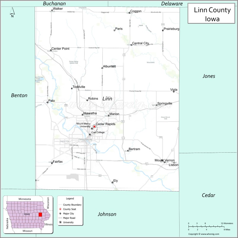
About Linn County Map, Iowa: The map showing the county boundary, county seat, major cities, highways, water bodies and neighbouring counties.
More Iowa Maps & Info
| Iowa Map | Iowa County Map | Iowa Cities Map |
| Iowa Zip codes | Where is Iowa | Airports in Iowa |
| Iowa Area Codes | Iowa Blank Map | Iowa River Map |
| Iowa Physical Map | Iowa Road Map | Where is Des Moines |
Map of Linn County, Iowa
Linn County is a county located in the U.S. state of Iowa. It's county seat is Cedar Rapids. As per 2020 census, the population of Linn County is 228939 people and population density is square miles. According to the United States Census Bureau, the county has a total area of 718 sq mi (1,860 km2). Linn County was established on -22654.
Linn County Facts
| Continent | North America |
| Country | United States |
| State | Iowa |
| County Seat | Cedar Rapids |
| Largest City/Town | Cedar Rapids |
| Established | December 21, 1837 |
| Total Area | 725 sq mi (1,878 sq km) |
| Land Area | 717 sq mi (1,857 sq km) |
| Water Area | 8 sq mi (21 sq km) |
| Population | 230,299 (Census 2020) |
| Population Density | 321.2 people per sq mi |
| Time Zone | Central Time Zone (CT) |
| Major Highways | Interstate 380, U.S. Highway 30, U.S. Highway 151, U.S. Highway 218, Iowa Highway 1, Iowa Highway 13, Iowa Highway 27 |
| Major Rivers | Cedar River, Wapsipinicon River |
| Neighboring Counties | Benton County, Buchanan County, Delaware County, Jones County, Cedar County, Johnson County, Iowa County |
| Famous For | Cedar Rapids, manufacturing, food processing, education, arts, and technology industries |
| Top Attractions | National Czech & Slovak Museum, Brucemore, Cedar Rapids Museum of Art, Indian Creek Nature Center |
| Official Website | Official Website |
About Linn County, Iowa
Linn County is located in the east-central part of Iowa and was established in 1837. The county seat and largest city is Cedar Rapids. The county is the second-most populous county in Iowa and serves as a major center for manufacturing, healthcare, education, and commerce. The Cedar River flows through the county and has played an important role in its economic and cultural development.
Cities and Towns in Linn County, Iowa
| City/Town | Population (Census 2020) | Latitude & Longitude |
|---|---|---|
| Cedar Rapids (county seat) | 137,710 | 41.9779°N, 91.6656°W |
| Marion | 39,582 | 42.0347°N, 91.5969°W |
| Hiawatha | 7,183 | 42.0433°N, 91.6763°W |
| Mount Vernon | 4,527 | 41.9239°N, 91.4166°W |
| Robins | 3,353 | 42.0728°N, 91.6721°W |
| Center Point | 2,579 | 42.1919°N, 91.7857°W |
| Fairfax | 2,357 | 41.9197°N, 91.7816°W |
| Lisbon | 2,233 | 41.9214°N, 91.3852°W |
| Ely | 2,026 | 41.8747°N, 91.5849°W |
| Central City | 1,257 | 42.2033°N, 91.5241°W |
| Palo | 1,123 | 42.0708°N, 91.7952°W |
| Springville | 1,074 | 42.0594°N, 91.4421°W |
| Coggon | 682 | 42.2806°N, 91.5271°W |
| Alburnett | 673 | 42.1497°N, 91.6185°W |
| Bertram | 294 | 42.0528°N, 91.5338°W |
| Prairieburg | 178 | 42.2650°N, 91.4308°W |
| Toddville (CDP) | 1,109 | 42.0983°N, 91.7268°W |
| Waubeek (CDP) | 150 | 42.1583°N, 91.4602°W |
Best Golf Courses in Linn County, Iowa
| Golf Course | Location | Latitude & Longitude |
|---|---|---|
| Airport National Golf Course | Cedar Rapids | 41.8894°N, 91.7132°W |
| Cedar Rapids Country Club | Cedar Rapids | 42.0162°N, 91.7095°W |
| Elmcrest Country Club | Cedar Rapids | 42.0187°N, 91.6396°W |
| Ellis Golf Course | Cedar Rapids | 41.9874°N, 91.6948°W |
| Gardner Golf Course | Marion | 42.0298°N, 91.5865°W |
| Hunters Ridge Golf Course | Marion | 42.0176°N, 91.5436°W |
| Kernoustie Golf Club | Mount Vernon | 41.9322°N, 91.4318°W |
| Squaw Creek Golf Course | Marion | 42.0515°N, 91.6023°W |
| Twin Pines Golf Course | Cedar Rapids | 41.9632°N, 91.6289°W |
| Wanatee Park Golf Course | Marion | 42.0684°N, 91.5461°W |
What are Major Roads and Highways in Linn County
Major highways connect the county to nearby regions and cities.
- Interstate 380 - north-south freeway connecting Cedar Rapids with Waterloo and Iowa City
- U.S. Highway 30 - east-west route connecting Cedar Rapids with Tama and Clinton
- U.S. Highway 151 - links Cedar Rapids with Dubuque and southern Iowa
- U.S. Highway 218 - regional north-south route through Cedar Rapids
- Iowa Highway 13 - connects Marion with Manchester and Interstate 80
- Iowa Highway 1 - serves Mount Vernon and Lisbon
- Iowa Highway 27 - Avenue of the Saints corridor through the county
Neighboring Counties of Linn County
- Buchanan County (north)
- Delaware County (northeast)
- Jones County (east)
- Cedar County (southeast)
- Johnson County (south)
- Iowa County (southwest)
- Benton County (west)
What are Top Attractions in Linn County, Iowa
The county offers a mix of natural and cultural attractions.
| Main Sight Name | City | Famous For |
|---|---|---|
| National Czech & Slovak Museum & Library | Cedar Rapids | Czech and Slovak heritage exhibits |
| Brucemore | Cedar Rapids | Historic mansion and estate |
| Cedar Rapids Museum of Art | Cedar Rapids | Grant Wood collection and regional art |
| Indian Creek Nature Center | Cedar Rapids | Nature trails and environmental education |
| Palisades-Kepler State Park | Mount Vernon | Scenic Cedar River bluffs and hiking |
| African American Museum of Iowa | Cedar Rapids | African American history and culture |
| NewBo City Market | Cedar Rapids | Local food, shopping, and events |
| Paramount Theatre | Cedar Rapids | Historic performing arts venue |
| Ushers Ferry Historic Village | Cedar Rapids | Living history museum |
| Lowe Park | Marion | Gardens, trails, and community events |
| Lindale Mall Area | Cedar Rapids | Major shopping destination |
| Cedar Valley Nature Trail | Countywide | Biking and outdoor recreation |
Distance from Linn County to Nearby Cities
The following distances are measured by road (driving).
- Cedar Rapids to Marion (Linn County), Iowa - 5 mi (8 km)
- Cedar Rapids to Hiawatha (Linn County), Iowa - 5 mi (8 km)
- Cedar Rapids to Iowa City (Johnson County), Iowa - 31 mi (50 km)
- Cedar Rapids to Anamosa (Jones County), Iowa - 28 mi (45 km)
- Cedar Rapids to Tipton (Cedar County), Iowa - 36 mi (58 km)
- Cedar Rapids to Vinton (Benton County), Iowa - 33 mi (53 km)
- Cedar Rapids to Manchester (Delaware County), Iowa - 41 mi (66 km)
- Cedar Rapids to Independence (Buchanan County), Iowa - 33 mi (53 km)
- Cedar Rapids to Waterloo (Black Hawk County), Iowa - 57 mi (92 km)
- Cedar Rapids to Dubuque (Dubuque County), Iowa - 71 mi (114 km)
- Cedar Rapids to Davenport (Scott County), Iowa - 75 mi (121 km)
- Cedar Rapids to Des Moines (Polk County), Iowa - 122 mi (196 km)
- Cedar Rapids to Galena, Illinois - 84 mi (135 km)
- Cedar Rapids to Rockford, Illinois - 145 mi (233 km)
- Cedar Rapids to Chicago, Illinois - 248 mi (399 km)
Nearest Airports
Nearest airport of Linn is Des Moines International Airport.
References
- QuickFacts - U.S. Census Bureau
- United States Census Bureau Profile
- United States Geological Survey (USGS)
- National Geodetic Survey
- Official County Website
- Adair County Map
- Adams County Map
- Allamakee County Map
- Appanoose County Map
- Audubon County Map
- Benton County Map
- Black Hawk County Map
- Boone County Map
- Bremer County Map
- Buchanan County Map
- Buena Vista County Map
- Butler County Map
- Calhoun County Map
- Carroll County Map
- Cass County Map
- Cedar County Map
- Cerro Gordo County Map
- Cherokee County Map
- Chickasaw County Map
- Clarke County Map
- Clay County Map
- Clayton County Map
- Clinton County Map
- Crawford County Map
- Dallas County Map
- Davis County Map
- Decatur County Map
- Delaware County Map
- Des Moines County Map
- Dickinson County Map
- Dubuque County Map
- Emmet County Map
- Fayette County Map
- Floyd County Map
- Franklin County Map
- Fremont County Map
- Greene County Map
- Grundy County Map
- Guthrie County Map
- Hamilton County Map
- Hancock County Map
- Hardin County Map
- Harrison County Map
- Henry County Map
- Howard County Map
- Humboldt County Map
- Ida County Map
- Iowa County Map
- Jackson County Map
- Jasper County Map
- Jefferson County Map
- Johnson County Map
- Jones County Map
- Keokuk County Map
- Kossuth County Map
- Lee County Map
- Linn County Map
- Louisa County Map
- Lucas County Map
- Lyon County Map
- Madison County Map
- Mahaska County Map
- Marion County Map
- Marshall County Map
- Mills County Map
- Mitchell County Map
- Monona County Map
- Monroe County Map
- Montgomery County Map
- Muscatine County Map
- O'Brien County Map
- Osceola County Map
- Page County Map
- Palo Alto County Map
- Plymouth County Map
- Pocahontas County Map
- Polk County Map
- Pottawattamie County Map
- Poweshiek County Map
- Ringgold County Map
- Sac County Map
- Scott County Map
- Shelby County Map
- Sioux County Map
- Story County Map
- Tama County Map
- Taylor County Map
- Union County Map
- Van Buren County Map
- Wapello County Map
- Warren County Map
- Washington County Map
- Wayne County Map
- Webster County Map
- Winnebago County Map
- Winneshiek County Map
- Woodbury County Map
- Worth County Map
- Wright County Map
- Alabama Counties
- Alaska boroughs
- Arizona Counties
- Arkansas Counties
- California County Map
- Colorado Counties
- Connecticut Counties
- Delaware Counties
- Florida County Map
- Georgia County Map
- Hawaii Counties
- Idaho Counties
- Illinois Counties
- Indiana Counties
- Iowa Counties
- Kansas Counties
- Kentucky Counties
- Louisiana Counties
- Maine Counties
- Maryland Counties
- Massachusetts Counties
- Michigan County Map
- Minnesota Counties
- Mississippi Counties
- Missouri Counties
- Montana Counties
- Nebraska Counties
- Nevada Counties
- New York Counties
- New Hampshire Counties
- New Jersey Counties
- New Mexico Counties
- North Carolina Counties
- North Dakota Counties
- Ohio County Map
- Oklahoma Counties
- Oregon Counties
- Pennsylvania Counties
- Rhode Island Counties
- South Carolina Counties
- South Dakota Counties
- Map of Tennessee
- Texas County Map
- Utah Counties
- Vermont Counties
- Virginia Counties
- Washington Counties
- West Virginia Counties
- Wisconsin Counties
- Wyoming Counties