Written and Fact-checked by Whereig Editors | Last Updated On: June 10, 2026
Map of Hardin County - Hardin County is a county located in the U.S. state of Iowa. Hardin County Map showing cities, highways, important places and water bodies. Get Where is Hardin County located in the map, major cities in Hardin county, population, areas, and places of interest.
Hardin County Map, Iowa
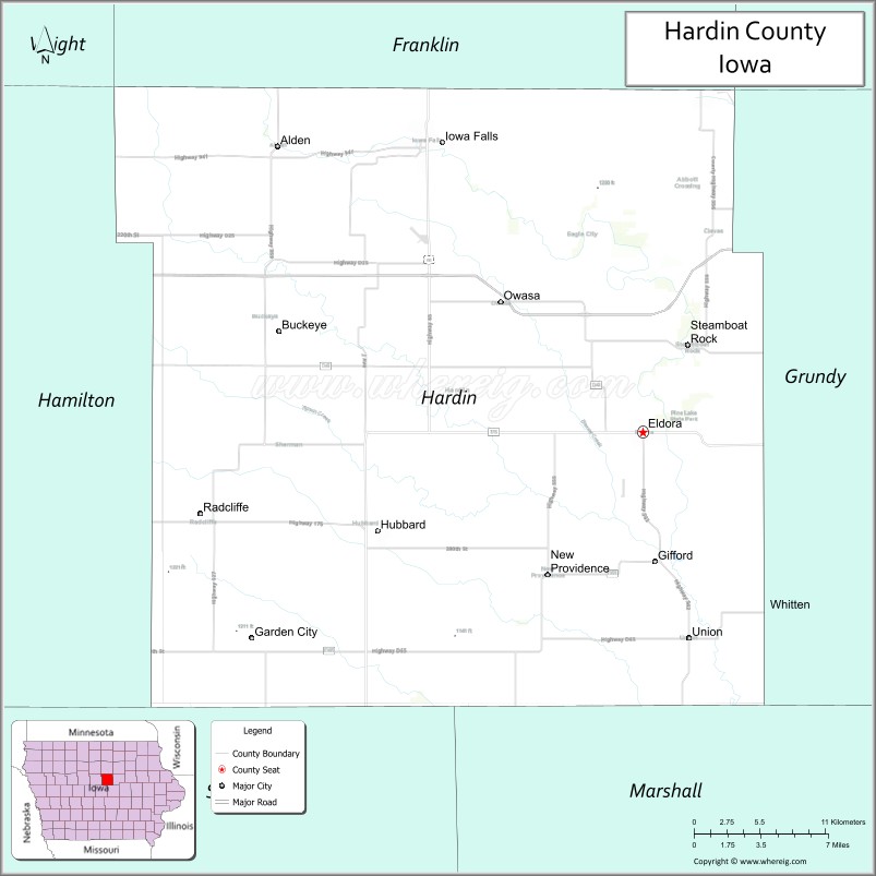
About Hardin County Map, Iowa: The map showing the county boundary, county seat, major cities, highways, water bodies and neighbouring counties.
More Iowa Maps & Info
| Iowa Map | Iowa County Map | Iowa Cities Map |
| Iowa Zip codes | Where is Iowa | Airports in Iowa |
| Iowa Area Codes | Iowa Blank Map | Iowa River Map |
| Iowa Physical Map | Iowa Road Map | Where is Des Moines |
Map of Hardin County, Iowa
Hardin County is a county located in the U.S. state of Iowa. It's county seat is Eldora. As per 2020 census, the population of Hardin County is 16708 people and population density is square miles. According to the United States Census Bureau, the county has a total area of 569 sq mi (1,474 km2). Hardin County was established on -17881.
Hardin County Facts
| Continent | North America |
| Country | United States |
| State | Iowa |
| County Seat | Eldora |
| Largest City/Town | Iowa Falls |
| Established | January 15, 1851 |
| Total Area | 570 sq mi (1,476 sq km) |
| Land Area | 569 sq mi (1,474 sq km) |
| Water Area | 1 sq mi (2 sq km) |
| Population | 16,385 (Census 2020) |
| Population Density | 28.8 people per sq mi |
| Time Zone | Central Time Zone (CT) |
| Major Highways | U.S. Highway 20, U.S. Highway 65, Iowa Highway 175, Iowa Highway 57, Iowa Highway 14 |
| Major Rivers | Iowa River, South Fork Iowa River |
| Neighboring Counties | Franklin County, Grundy County, Marshall County, Story County, Hamilton County, Wright County |
| Famous For | Iowa Falls, Eldora, scenic Iowa River valley, Pine Lake State Park, historic limestone architecture |
| Top Attractions | Pine Lake State Park, Calkins Nature Area, Hardin County Farm Museum, Iowa River Greenbelt |
| Official Website | Official Website |
About Hardin County, Iowa
Hardin County is located in central Iowa and was established in 1851. The county seat is Eldora, while Iowa Falls is the largest city. The county is known for the scenic Iowa River Valley, rolling landscapes, and a strong agricultural economy. Hardin County also features historic communities, outdoor recreation areas, and educational institutions that serve the surrounding region.
Cities and Towns in Hardin County, Iowa
| City/Town | Population (Census 2020) | Latitude & Longitude |
|---|---|---|
| Eldora (county seat) | 2,732 | 42.3608°N, 93.1008°W |
| Iowa Falls | 5,193 | 42.5222°N, 93.2652°W |
| Alden | 787 | 42.5205°N, 93.3766°W |
| Ackley (part) | 1,589 | 42.5547°N, 93.0546°W |
| Hubbard | 808 | 42.3058°N, 93.3008°W |
| New Providence | 228 | 42.2817°N, 93.1885°W |
| Radcliffe | 545 | 42.2947°N, 93.4171°W |
| Steamboat Rock | 264 | 42.4117°N, 93.0610°W |
| Union | 370 | 42.2481°N, 93.0714°W |
| Whitten | 37 | 42.3919°N, 93.1299°W |
| Buckeye | 92 | 42.4194°N, 93.3777°W |
| Gifford | 22 | 42.3372°N, 93.1876°W |
| Owasa | 38 | 42.4761°N, 93.2209°W |
| Garden City | 98 | 42.2439°N, 93.4014°W |
Best Golf Courses in Hardin County, Iowa
| Golf Course | Location | Latitude & Longitude |
|---|---|---|
| Highland Country Club | Iowa Falls | 42.5198°N, 93.2828°W |
| Pine Lake Country Club | Eldora | 42.3716°N, 93.1137°W |
| Meadow Hills Golf Course | Iowa Falls | 42.5284°N, 93.2578°W |
| Alden Golf Club | Alden | 42.5192°N, 93.3894°W |
What are Major Roads and Highways in Hardin County
Major highways connect the county to nearby regions and cities.
- U.S. Highway 20 - major east-west corridor linking Iowa Falls, Eldora, Waterloo, and Fort Dodge
- U.S. Highway 65 - north-south route connecting the county with Mason City, Des Moines, and surrounding communities
- Iowa Highway 175 - important regional highway serving Eldora and nearby towns
- Iowa Highway 57 - provides access across northern Hardin County
- Iowa Highway 14 - serves western and central portions of the county
Neighboring Counties of Hardin County
- Franklin County (north)
- Wright County (northwest)
- Hamilton County (west)
- Story County (southwest)
- Marshall County (south)
- Grundy County (east)
What are Top Attractions in Hardin County, Iowa
The county offers a mix of natural and cultural attractions.
| Main Sight Name | City | Famous For |
|---|---|---|
| Pine Lake State Park | Eldora | Iowa's second-oldest state park with hiking, camping, and fishing |
| Calkins Nature Area | Eldora | Woodland trails, wildlife, and environmental education |
| Hardin County Farm Museum | Eldora | Agricultural history and vintage farming equipment |
| Iowa River Greenbelt | Iowa Falls | Scenic river views, trails, and outdoor recreation |
| Metropolitan Opera House | Iowa Falls | Historic performing arts venue |
| Princess Theatre | Eldora | Restored historic theater and entertainment venue |
| Steamboat Rock Historic District | Steamboat Rock | Historic riverfront community and architecture |
| Ellsworth Community College | Iowa Falls | Educational campus and community events |
| Lower Pine Lake | Eldora | Fishing, boating, and lakeside recreation |
| Upper Pine Lake | Eldora | Camping and outdoor activities |
| Union Grove State Recreation Area | Union | Picnic areas and outdoor recreation |
| Eagle City Winery | Iowa Falls | Local wines and countryside views |
Distance from Hardin County to Nearby Cities
The following distances are measured by road (driving).
- Eldora to Iowa Falls (Hardin County), Iowa - 14 mi (23 km)
- Eldora to Hampton (Franklin County), Iowa - 30 mi (48 km)
- Eldora to Grundy Center (Grundy County), Iowa - 18 mi (29 km)
- Eldora to Marshalltown (Marshall County), Iowa - 29 mi (47 km)
- Eldora to Ames (Story County), Iowa - 32 mi (52 km)
- Eldora to Webster City (Hamilton County), Iowa - 33 mi (53 km)
- Eldora to Clarion (Wright County), Iowa - 36 mi (58 km)
- Eldora to Fort Dodge (Webster County), Iowa - 52 mi (84 km)
- Eldora to Waterloo (Black Hawk County), Iowa - 47 mi (76 km)
- Eldora to Cedar Falls (Black Hawk County), Iowa - 50 mi (80 km)
- Eldora to Mason City (Cerro Gordo County), Iowa - 63 mi (101 km)
- Eldora to Cedar Rapids (Linn County), Iowa - 86 mi (138 km)
- Eldora to Des Moines (Polk County), Iowa - 67 mi (108 km)
- Eldora to Dubuque (Dubuque County), Iowa - 122 mi (196 km)
- Eldora to Minneapolis, Minnesota - 185 mi (298 km)
Nearest Airports
Nearest airport of Hardin is La Crosse Municipal Airport (LSE / KLSE).
References
- QuickFacts - U.S. Census Bureau
- United States Census Bureau
- United States Geological Survey (USGS)
- National Geodetic Survey
- Official County Website
- Adair County Map
- Adams County Map
- Allamakee County Map
- Appanoose County Map
- Audubon County Map
- Benton County Map
- Black Hawk County Map
- Boone County Map
- Bremer County Map
- Buchanan County Map
- Buena Vista County Map
- Butler County Map
- Calhoun County Map
- Carroll County Map
- Cass County Map
- Cedar County Map
- Cerro Gordo County Map
- Cherokee County Map
- Chickasaw County Map
- Clarke County Map
- Clay County Map
- Clayton County Map
- Clinton County Map
- Crawford County Map
- Dallas County Map
- Davis County Map
- Decatur County Map
- Delaware County Map
- Des Moines County Map
- Dickinson County Map
- Dubuque County Map
- Emmet County Map
- Fayette County Map
- Floyd County Map
- Franklin County Map
- Fremont County Map
- Greene County Map
- Grundy County Map
- Guthrie County Map
- Hamilton County Map
- Hancock County Map
- Hardin County Map
- Harrison County Map
- Henry County Map
- Howard County Map
- Humboldt County Map
- Ida County Map
- Iowa County Map
- Jackson County Map
- Jasper County Map
- Jefferson County Map
- Johnson County Map
- Jones County Map
- Keokuk County Map
- Kossuth County Map
- Lee County Map
- Linn County Map
- Louisa County Map
- Lucas County Map
- Lyon County Map
- Madison County Map
- Mahaska County Map
- Marion County Map
- Marshall County Map
- Mills County Map
- Mitchell County Map
- Monona County Map
- Monroe County Map
- Montgomery County Map
- Muscatine County Map
- O'Brien County Map
- Osceola County Map
- Page County Map
- Palo Alto County Map
- Plymouth County Map
- Pocahontas County Map
- Polk County Map
- Pottawattamie County Map
- Poweshiek County Map
- Ringgold County Map
- Sac County Map
- Scott County Map
- Shelby County Map
- Sioux County Map
- Story County Map
- Tama County Map
- Taylor County Map
- Union County Map
- Van Buren County Map
- Wapello County Map
- Warren County Map
- Washington County Map
- Wayne County Map
- Webster County Map
- Winnebago County Map
- Winneshiek County Map
- Woodbury County Map
- Worth County Map
- Wright County Map
- Alabama Counties
- Alaska boroughs
- Arizona Counties
- Arkansas Counties
- California County Map
- Colorado Counties
- Connecticut Counties
- Delaware Counties
- Florida County Map
- Georgia County Map
- Hawaii Counties
- Idaho Counties
- Illinois Counties
- Indiana Counties
- Iowa Counties
- Kansas Counties
- Kentucky Counties
- Louisiana Counties
- Maine Counties
- Maryland Counties
- Massachusetts Counties
- Michigan County Map
- Minnesota Counties
- Mississippi Counties
- Missouri Counties
- Montana Counties
- Nebraska Counties
- Nevada Counties
- New York Counties
- New Hampshire Counties
- New Jersey Counties
- New Mexico Counties
- North Carolina Counties
- North Dakota Counties
- Ohio County Map
- Oklahoma Counties
- Oregon Counties
- Pennsylvania Counties
- Rhode Island Counties
- South Carolina Counties
- South Dakota Counties
- Map of Tennessee
- Texas County Map
- Utah Counties
- Vermont Counties
- Virginia Counties
- Washington Counties
- West Virginia Counties
- Wisconsin Counties
- Wyoming Counties