Written and Fact-checked by Whereig Editors | Last Updated On: June 10, 2026
Map of Clayton County - Clayton County is a county located in the U.S. state of Iowa. Clayton County Map showing cities, highways, important places and water bodies. Get Where is Clayton County located in the map, major cities in Clayton county, population, areas, and places of interest.
Clayton County Map, Iowa
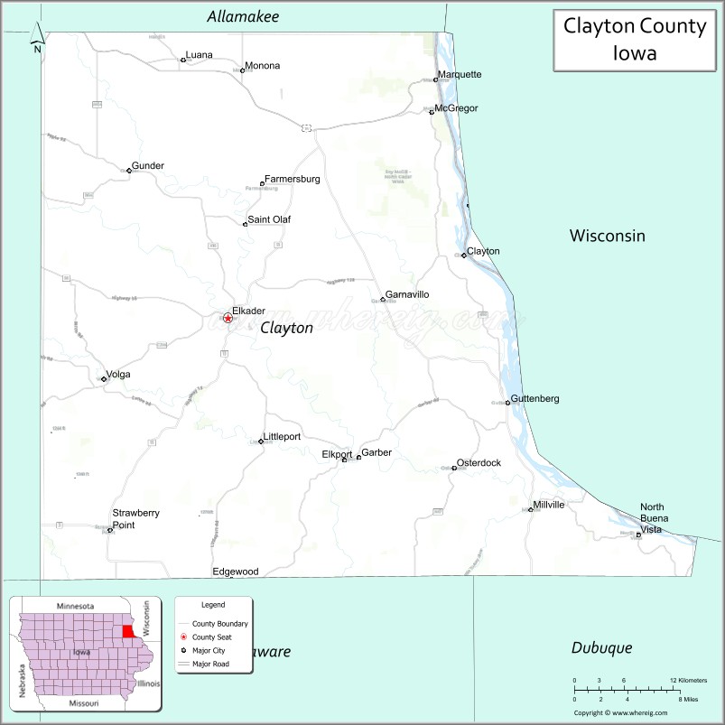
About Clayton County Map, Iowa: The map showing the county boundary, county seat, major cities, highways, water bodies and neighbouring counties.
More Iowa Maps & Info
| Iowa Map | Iowa County Map | Iowa Cities Map |
| Iowa Zip codes | Where is Iowa | Airports in Iowa |
| Iowa Area Codes | Iowa Blank Map | Iowa River Map |
| Iowa Physical Map | Iowa Road Map | Where is Des Moines |
Map of Clayton County, Iowa
Clayton County is a county located in the U.S. state of Iowa. It's county seat is Elkader. As per 2020 census, the population of Clayton County is 16998 people and population density is square miles. According to the United States Census Bureau, the county has a total area of 779 sq mi (2,018 km2). Clayton County was established on -22654.
Clayton County Facts
| Continent | North America |
| Country | United States |
| State | Iowa |
| County Seat | Elkader |
| Largest City/Town | McGregor |
| Established | December 21, 1837 |
| Total Area | 793 sq mi (2,054 sq km) |
| Land Area | 779 sq mi (2,018 sq km) |
| Water Area | 14 sq mi (36 sq km) |
| Population | 17,315 (Census 2020) |
| Population Density | 22.2 people per sq mi |
| Time Zone | Central Time Zone (CT) |
| Major Highways | U.S. Highway 18, U.S. Highway 52, Iowa Highway 3, Iowa Highway 13 |
| Major Rivers | Mississippi River, Turkey River, Volga River |
| Neighboring Counties | Allamakee County, Fayette County, Dubuque County, Crawford County (WI), Grant County (WI) |
| Famous For | Effigy Mounds region, Mississippi River bluffs, historic river towns, Driftless Area scenery |
| Top Attractions | Effigy Mounds National Monument, Pikes Peak State Park, Spook Cave, Mississippi River overlooks |
| Official Website | Official Website |
About Clayton County, Iowa
Clayton County is located in northeastern Iowa and was established in 1837. The county seat is Elkader, while McGregor is the largest city. The county lies within Iowa's Driftless Area, a region known for rugged hills, deep river valleys, limestone bluffs, and scenic landscapes untouched by the last glacier. Clayton County is one of Iowa's leading tourism destinations thanks to its parks, river communities, and outdoor recreation opportunities.
Cities and Towns in Clayton County, Iowa
| City/Town | Population (Census 2020) | Latitude & Longitude |
|---|---|---|
| Elkader (county seat) | 1,209 | 42.8535°N, 91.4032°W |
| McGregor | 742 | 43.0211°N, 91.1765°W |
| Guttenberg | 1,817 | 42.7856°N, 91.1007°W |
| Monona | 1,471 | 43.0558°N, 91.3896°W |
| Strawberry Point | 1,195 | 42.6842°N, 91.5357°W |
| Edgewood (part) | 864 | 42.6447°N, 91.4010°W |
| Garnavillo | 745 | 42.8686°N, 91.2354°W |
| Elkport | 29 | 42.7410°N, 91.4560°W |
| Farmersburg | 302 | 42.9688°N, 91.3675°W |
| St. Olaf | 108 | 42.9308°N, 91.3897°W |
| Volga | 179 | 42.8014°N, 91.5418°W |
| Clayton | 39 | 42.9044°N, 91.3243°W |
| Marquette | 241 | 43.0437°N, 91.1826°W |
| North Buena Vista (part) | 93 | 42.8834°N, 90.9562°W |
| Luxemburg | 245 | 42.6045°N, 91.0747°W |
| Millville | 24 | 42.7317°N, 91.2558°W |
| Colesburg | 386 | 42.6458°N, 91.3652°W |
| Osterdock | 49 | 42.7314°N, 91.0118°W |
Best Golf Courses in Clayton County, Iowa
| Golf Course | Location | Latitude & Longitude |
|---|---|---|
| Elkader Golf & Country Club | Elkader | 42.8448°N, 91.4118°W |
| Guttenberg Golf & Country Club | Guttenberg | 42.7929°N, 91.1125°W |
| Backbone Golf & Country Club | Strawberry Point | 42.6725°N, 91.5437°W |
| Tri-City Golf Course | Luana | 43.0582°N, 91.4596°W |
What are Major Roads and Highways in Clayton County
Major highways connect the county to nearby regions and cities.
- U.S. Highway 18 - crosses northern Clayton County and connects McGregor, Monona and surrounding communities
- U.S. Highway 52 - follows the Mississippi River corridor and links Guttenberg, Garnavillo and Dubuque
- Iowa Highway 3 - east-west route serving Strawberry Point and western portions of the county
- Iowa Highway 13 - connects Elkader with northeastern Iowa communities and the Mississippi River region
Neighboring Counties of Clayton County
- Allamakee County (north)
- Crawford County, Wisconsin (east)
- Grant County, Wisconsin (southeast)
- Dubuque County (south)
- Fayette County (west)
What are Top Attractions in Clayton County, Iowa
The county offers a mix of natural and cultural attractions.
| Main Sight Name | City | Famous For |
|---|---|---|
| Effigy Mounds National Monument | Harpers Ferry Area | Ancient Native American earthworks and hiking trails |
| Pikes Peak State Park | McGregor | Panoramic Mississippi River bluff views |
| Spook Cave | McGregor | Underground boat tours through a natural cave |
| Mississippi River Overlook | McGregor | Scenic views of the river valley and Wisconsin bluffs |
| Turkey River Recreation Corridor | Elkader | Canoeing, kayaking and fishing opportunities |
| Keystone Bridge | Elkader | Historic stone arch bridge built in 1889 |
| Motor Mill Historic Site | Elkader | Restored grist mill and historic village |
| Guttenberg Riverwalk | Guttenberg | Mississippi River views and waterfront recreation |
| Driftless Area Scenic Byway | Countywide | Beautiful drives through rugged terrain and valleys |
| Volga River State Recreation Area | Volga | Camping, trails and outdoor recreation |
| Bloody Run Creek Area | Marquette | Trout fishing and scenic limestone valleys |
| Monona Butterfly Gardens | Monona | Public gardens and family-friendly outdoor attraction |
Distance from Clayton County to Nearby Cities
The following distances are measured by road (driving).
- Elkader to Decorah (Winneshiek County), Iowa - 37 mi (60 km)
- Elkader to Prairie du Chien, Wisconsin - 22 mi (35 km)
- Elkader to Dubuque (Dubuque County), Iowa - 53 mi (85 km)
- Elkader to Manchester (Delaware County), Iowa - 32 mi (51 km)
- Elkader to Oelwein (Fayette County), Iowa - 36 mi (58 km)
- Elkader to Waukon (Allamakee County), Iowa - 32 mi (51 km)
- Elkader to Guttenberg (Clayton County), Iowa - 18 mi (29 km)
- Elkader to McGregor (Clayton County), Iowa - 21 mi (34 km)
- Elkader to Cedar Rapids (Linn County), Iowa - 83 mi (134 km)
- Elkader to Waterloo (Black Hawk County), Iowa - 70 mi (113 km)
- Elkader to La Crosse, Wisconsin - 74 mi (119 km)
- Elkader to Iowa City (Johnson County), Iowa - 102 mi (164 km)
- Elkader to Madison, Wisconsin - 103 mi (166 km)
- Elkader to Rochester, Minnesota - 95 mi (153 km)
- Elkader to Des Moines (Polk County), Iowa - 177 mi (285 km)
References
- QuickFacts - U.S. Census Bureau
- United States Census Bureau
- United States Geological Survey (USGS)
- National Geodetic Survey
- Official County Website
- Adair County Map
- Adams County Map
- Allamakee County Map
- Appanoose County Map
- Audubon County Map
- Benton County Map
- Black Hawk County Map
- Boone County Map
- Bremer County Map
- Buchanan County Map
- Buena Vista County Map
- Butler County Map
- Calhoun County Map
- Carroll County Map
- Cass County Map
- Cedar County Map
- Cerro Gordo County Map
- Cherokee County Map
- Chickasaw County Map
- Clarke County Map
- Clay County Map
- Clayton County Map
- Clinton County Map
- Crawford County Map
- Dallas County Map
- Davis County Map
- Decatur County Map
- Delaware County Map
- Des Moines County Map
- Dickinson County Map
- Dubuque County Map
- Emmet County Map
- Fayette County Map
- Floyd County Map
- Franklin County Map
- Fremont County Map
- Greene County Map
- Grundy County Map
- Guthrie County Map
- Hamilton County Map
- Hancock County Map
- Hardin County Map
- Harrison County Map
- Henry County Map
- Howard County Map
- Humboldt County Map
- Ida County Map
- Iowa County Map
- Jackson County Map
- Jasper County Map
- Jefferson County Map
- Johnson County Map
- Jones County Map
- Keokuk County Map
- Kossuth County Map
- Lee County Map
- Linn County Map
- Louisa County Map
- Lucas County Map
- Lyon County Map
- Madison County Map
- Mahaska County Map
- Marion County Map
- Marshall County Map
- Mills County Map
- Mitchell County Map
- Monona County Map
- Monroe County Map
- Montgomery County Map
- Muscatine County Map
- O'Brien County Map
- Osceola County Map
- Page County Map
- Palo Alto County Map
- Plymouth County Map
- Pocahontas County Map
- Polk County Map
- Pottawattamie County Map
- Poweshiek County Map
- Ringgold County Map
- Sac County Map
- Scott County Map
- Shelby County Map
- Sioux County Map
- Story County Map
- Tama County Map
- Taylor County Map
- Union County Map
- Van Buren County Map
- Wapello County Map
- Warren County Map
- Washington County Map
- Wayne County Map
- Webster County Map
- Winnebago County Map
- Winneshiek County Map
- Woodbury County Map
- Worth County Map
- Wright County Map
- Alabama Counties
- Alaska boroughs
- Arizona Counties
- Arkansas Counties
- California County Map
- Colorado Counties
- Connecticut Counties
- Delaware Counties
- Florida County Map
- Georgia County Map
- Hawaii Counties
- Idaho Counties
- Illinois Counties
- Indiana Counties
- Iowa Counties
- Kansas Counties
- Kentucky Counties
- Louisiana Counties
- Maine Counties
- Maryland Counties
- Massachusetts Counties
- Michigan County Map
- Minnesota Counties
- Mississippi Counties
- Missouri Counties
- Montana Counties
- Nebraska Counties
- Nevada Counties
- New York Counties
- New Hampshire Counties
- New Jersey Counties
- New Mexico Counties
- North Carolina Counties
- North Dakota Counties
- Ohio County Map
- Oklahoma Counties
- Oregon Counties
- Pennsylvania Counties
- Rhode Island Counties
- South Carolina Counties
- South Dakota Counties
- Map of Tennessee
- Texas County Map
- Utah Counties
- Vermont Counties
- Virginia Counties
- Washington Counties
- West Virginia Counties
- Wisconsin Counties
- Wyoming Counties